Schwanheide
Schwanheide | |
|---|---|
 Coat of arms | |
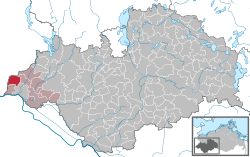
show Location of Schwanheide within Ludwigslust-Parchim district | |
 Schwanheide | |
| Coordinates: 53°25′N 10°40′E / 53.417°N 10.667°ECoordinates: 53°25′N 10°40′E / 53.417°N 10.667°E | |
| Country | Germany |
| State | Mecklenburg-Vorpommern |
| District | Ludwigslust-Parchim |
| Municipal assoc. | Boizenburg-Land |
| Subdivisions | 3 |
| Government | |
| • Mayor | Gerd Altenburg |
| Area | |
| • Total | 26.51 km2 (10.24 sq mi) |
| Elevation | 17 m (56 ft) |
| Population (2020-12-31)[1] | |
| • Total | 737 |
| • Density | 28/km2 (72/sq mi) |
| Time zone | UTC+01:00 (CET) |
| • Summer (DST) | UTC+02:00 (CEST) |
| Postal codes | 19258 |
| Dialling codes | 038842, 038847 |
| Vehicle registration | LWL |
| Website | www.amtboizenburgland.de |
Schwanheide is a municipality in the Ludwigslust-Parchim district, in Mecklenburg-Vorpommern, Germany.
History[]
Between 1945 and 1990 Schwanheide station served as East German inner German border crossing for rail transport. The crossing was open for trains travelling between the Soviet Zone of occupation in Germany (till 1949, thereafter the East German Democratic Republic, or West Berlin and the British zone of occupation (till 1949) and thereafter the West German Federal Republic of Germany. The traffic was subject to the Interzonal traffic regulations, that between West Germany and West Berlin followed the special regulations of the Transit Agreement (1972).
References[]
- ^ "Statistisches Amt M-V – Bevölkerungsstand der Kreise, Ämter und Gemeinden 2020". Statistisches Amt Mecklenburg-Vorpommern (in German). July 2021.
Categories:
- Municipalities in Mecklenburg-Vorpommern
- Inner German border
- Ludwigslust-Parchim
- Bezirk Schwerin
- Ludwigslust-Parchim geography stubs


