Kohimarama
Kohimarama | |
|---|---|
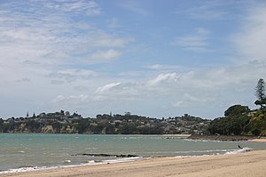 View of Kohimarama Beach | |
 | |
| Country | New Zealand |
| City | Auckland Council |
| Electoral ward | Ōrākei Ward |
| Population (2018) | |
| • Total | 4,350 |
| Waitematā Harbour, Devonport | Rangitoto Island, Tamaki Drive | Hauraki Gulf, Browns Island |
| Mission Bay, Orakei, Okahu Bay |
|
Saint Heliers |
| Meadowbank | St Johns | Glen Innes, Glendowie |
Kohimarama is a coastal residential Auckland suburb, located to the east of the city, with many homes having some of the best views across the Auckland Harbour. Kohimarama is situated between Mission Bay and St Heliers and has an accessible beach with a boardwalk and green recreational spaces located amongst residential areas. Local government of Kohimarama is the responsibility of the Ōrākei Local Board, which also includes the suburbs of Orakei, Mission Bay, St Heliers, Glendowie, St Johns, Meadowbank, Remuera and Ellerslie.[1]
Demographics[]
| Year | Pop. | ±% p.a. |
|---|---|---|
| 2006 | 4,035 | — |
| 2013 | 4,143 | +0.38% |
| 2018 | 4,350 | +0.98% |
| Source: [2] | ||

Kohimarama had a population of 4,350 at the 2018 New Zealand census, an increase of 207 people (5.0%) since the 2013 census, and an increase of 315 people (7.8%) since the 2006 census. There were 1,707 households. There were 2,064 males and 2,283 females, giving a sex ratio of 0.9 males per female. The median age was 44.7 years, with 753 people (17.3%) aged under 15 years, 603 (13.9%) aged 15 to 29, 2,106 (48.4%) aged 30 to 64, and 888 (20.4%) aged 65 or older.
Ethnicities were 83.9% European/Pākehā, 3.2% Māori, 1.4% Pacific peoples, 13.6% Asian, and 4.0% other ethnicities (totals add to more than 100% since people could identify with multiple ethnicities).
The proportion of people born overseas was 35.8%, compared with 27.1% nationally.
Although some people objected to giving their religion, 45.2% had no religion, 43.7% were Christian, and 6.1% had other religions.
Of those at least 15 years old, 1,647 (45.8%) people had a bachelor or higher degree, and 222 (6.2%) people had no formal qualifications. The median income was $53,000. The employment status of those at least 15 was that 1,857 (51.6%) people were employed full-time, 555 (15.4%) were part-time, and 81 (2.3%) were unemployed.[2]
History[]
Kohimarama used to be part of the Kohimarama Block, land purchased by the Crown from the indigenous Māori. This was a large area, from Orakei-Mission Bay to the Tamaki River and from the Waitematā Harbour to the outskirts of Panmure. Kohimarama’s former name was Waiparera, ‘duck water’, as the area was a breeding ground of the parera, the wild grey duck. This name was used by the Māori and by the European settlers, the Pākehā, until 1870. Arriving in Auckland in 1841, William Field Porter, was a month too late for the first Government auction, but became the first settler in today’s Kohimarama after the second auction. Then the area consisted of a lagoon, a raupo swamp and the Kohimarama beach, the longest beach in the Harbour. Porter sent men to clear, fence and drain the area. One of these men was Thomas Kemp, later to be a landowner of the neighbouring suburb, Mission Bay.[3]
The Kohimarama Wharf was built in 1912 on the Pipimea Head between Kohimarama and Mission Bay.[3][4] The first business in Kohimarama was a tearoom which catered to the people arriving at the newly built wharf. The access to the wharf was not easy; people had to walk around the rocks to and from the wharf which ultimately led to the building of the road now known as Tamaki Drive.[3]
From 1892 to 1919, Kohimarama was also known as the ‘Jockey Bay’, since the area was used as a training ground for race horses. In 1919, the stables were moved to Ronaki Road, Mission Bay, and the land in Kohimarama was leased to W.H. Madill, a dairy farmer.[3]
Today, Kohimarama is one of the quieter beaches along Tamaki Drive with some cosy cafes present along the beach front. The Kohimarama Yacht Club is located on Tamaki Drive. This club was set up in 1939 for young people and the construction of the club house at Gower’s Point, between the Kohimarama and Saint Heliers, was finished in 1957.[3]
Nature areas[]
Kohimarama has several nature reserves: Madills Farm Recreation Reserve, Mary Atkin Reserve, Kohimarama Beach Reserve, Sage Road Reserve and Speight Road Reserve.[5] Madills Farm Recreation Reserve used to be part of W.H. Madill's dairy farm in 1919. There are four playing fields on the northern half of the reserve.[3] Mary Atkin Reserve, named after an early missionary daughter, is a green open space where people can walk dogs.[6] Kohimarama Beach Reserve is mainly used for swimming. It is located east of the Kohimarama Yacht Club and many boat races are held there. It has boat ramps, bicycle stands and toilets.[7] Sage Road Reserve and Speight Road Reserve each function as an access way to Madills Farm Recreation Reserve.[8][9]
Education[]
Selwyn College is a secondary school (years 9–13) with a roll of 1296.[10]
Kohimarama School and St Thomas School are full primary schools (years 1–8) with rolls of 545 and 718 students, respectively.[11][12]
All these schools are co-educational. Rolls are as of November 2021.[13]
Sports[]
The football (soccer) club Eastern Suburbs AFC, which competes in the Lotto Sport Italia NRFL Division 1 and was crowned champion in 2011, is based in Kohimarama. Other sports clubs are the Kohimarama Tennis Club, the Kohimarama Yacht Club and Kohimarama Bowling Club which was formerly known as the Mission Bay Women's Bowling Club. The club changed its name in October 2013 after changing the rules about allowing men to join the club.[14]
Gallery[]

Kohimarama
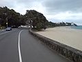
Kohimarama beach and Tamaki Drive

Sunrise on 1 May 2009

Kohimarama


References[]
- ^ "About the Orākei area". Auckland Council. 2013. Archived from the original on 26 March 2014. Retrieved 25 March 2014.Retrieved 2013-03-10.
- ^ a b "Statistical area 1 dataset for 2018 Census". Statistics New Zealand. March 2020. Kohimarama (141800). 2018 Census place summary: Kohimarama
- ^ a b c d e f Elizabeth T. Jackson (1976). Delving Into The Past of Auckland’s Eastern Suburbs: Section 4 Mission bay, Section 5 Kohimarama. Auckland, N.Z.
- ^ "Looking South from Kohimarama...1931". Sir George Grey Special Collections, Auckland Libraries, Auckland Council. Retrieved 2013-10-17.
- ^ "Find a Park". Auckland Council. 2013. Retrieved 18 October 2013.
- ^ "Mary Atkin Reserve". Auckland Council. 2013. Retrieved 18 October 2013.
- ^ "Kohimarama Beach Reserve". Auckland Council. 2013. Retrieved 18 October 2013.
- ^ "Sage Road Reserve". Auckland Council. 2013. Retrieved 18 October 2013.
- ^ "Speight Road Reserve". Auckland Council. 2013. Retrieved 18 October 2013.
- ^ Education Counts: Selwyn College
- ^ Education Counts: Kohimarama School
- ^ Education Counts: St Thomas School
- ^ "New Zealand Schools Directory". New Zealand Ministry of Education. Retrieved 22 December 2021.
- ^ Mathew Dearnaley (15 October 2013). "' Hubby bowls up to cross gender divide'". The New Zealand Herald. Retrieved 2013-10-21.
- The Lively Capital, Auckland 1840-1865, Una Platts. Avon Fine Prints Limited New Zealand 1971.
External links[]
- Photographs of Kohimarama held in Auckland Libraries' heritage collections.
Coordinates: 36°51′33″S 174°50′45″E / 36.859074°S 174.845808°E

- Suburbs of Auckland
- Populated places around the Hauraki Gulf / Tīkapa Moana