Komaki
Komaki
小牧市 | |
|---|---|
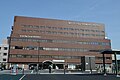
 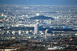 Upper:Komaki Castle Lower:Komaki Skyline | |
 Flag Seal | |
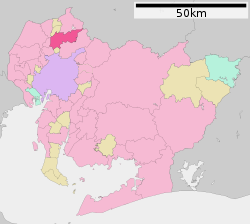 Location of Komaki in Aichi Prefecture | |
 Komaki | |
| Coordinates: 35°17′27.6″N 136°54′43.6″E / 35.291000°N 136.912111°ECoordinates: 35°17′27.6″N 136°54′43.6″E / 35.291000°N 136.912111°E | |
| Country | Japan |
| Region | Chūbu (Tōkai) |
| Prefecture | Aichi |
| Government | |
| • - Mayor | Suzuo Yamashita |
| Area | |
| • Total | 62.81 km2 (24.25 sq mi) |
| Population (1 October 2019) | |
| • Total | 148,872 |
| • Density | 2,400/km2 (6,100/sq mi) |
| Time zone | UTC+9 (Japan Standard Time) |
| - Tree | Tabunoki (Machilus thunbergii) |
| - Flower | Azalea |
| Phone number | 0568-72-2101 |
| Address | 1-1 Horinouchi, Komaki-shi, Aichi-ken 485-8650 |
| Website | Official website |


Komaki (小牧市, Komaki-shi) is a city located in Aichi Prefecture, Japan. As of 1 October 2019, the city had an estimated population of 148,872 in 68,174 households,[1] and a population density of 2,370 inhabitants per square kilometre (6,100/sq mi). The total area of the city was 62.81 square kilometres (24.25 sq mi). Komaki is commonly associated with the former Komaki Airport, which is located on the border between Komaki and neighboring Kasugai.
Geography[]
Komaki is located in the middle of the Nōbi Plain, west-central Aichi Prefecture, north of the Nagoya metropolis. The city skyline is dominated by Mount Komaki, which is topped with .
Surrounding municipalities[]
Demographics[]
Per Japanese census data,[2] the population of Komaki has increased rapidly over the past 60 years.
| Year | Pop. | ±% |
|---|---|---|
| 1960 | 43,470 | — |
| 1970 | 79,606 | +83.1% |
| 1980 | 103,233 | +29.7% |
| 1990 | 124,441 | +20.5% |
| 2000 | 143,122 | +15.0% |
| 2010 | 147,059 | +2.8% |
Climate[]
The city has a climate characterized by hot and humid summers, and relatively mild winters (Köppen climate classification Cfa). The average annual temperature in Komaki is 15.7 °C (60.3 °F). The average annual rainfall is 1,769 mm (69.6 in) with September as the wettest month. The temperatures are highest on average in August, at around 28.1 °C (82.6 °F), and lowest in January, at around 4.2 °C (39.6 °F).[3]
History[]
Archaeological remains from the Japanese Paleolithic through Yayoi period have been found in what is now Komaki, and burial tumuli from the Kofun period are also common. During the Sengoku period, Oda Nobunaga used Komaki Castle as his headquarters from which he launched his invasion of Mino Province and later the area surrounding Mount Komaki was the site of the Battle of Komaki and Nagakute in 1584. It was part of the holdings of Owari Domain during the Edo period, and prospered as a post town on the route connecting Nagoya with the Nakasendō highway. During the Meiji period establishment of the modern municipalities system, the area was organized into villages under Higashikasugai District, Aichi. Komaki was proclaimed a town on July 16, 1906 through the merger of four villages. Komaki was raised to city status on January 1, 1955, after merging with the village of Kitasato in Nishikasugai District, Aichi.
Government[]
Komaki has a mayor-council form of government with a directly elected mayor and a unicameral city legislature of 25 members. The city contributes two members to the Aichi Prefectural Assembly. In terms of national politics, the city is part of Aichi District 6 of the lower house of the Diet of Japan.
Economy[]
Komaki has a mixed economy, with agriculture (rice and horticulture), commence, and light manufacturing industries playing important roles. Due to its highway connections with the Nagoya metropolis, it is also becoming a bedroom community.
Sumitomo Riko (Previously known as Tokai Gomme), a global rubber and synthetic resin products manufacturing company, whose automotive anti-vibration components hold the largest global market share, has its headquarters in the city.[4] Komaki's GDP per capita (Nominal) was ¥5,859,100 in 2014.[5][6]
Education[]

Aichi Bunkyo University

Nagoya Zokei University


- Universities and Colleges
- Elementary and secondary education
Komaki has 16 public elementary schools and nine public junior high schools operated by the city government, and three public high schools operated by the Aichi Prefectural Board of Education. There is also one private high school. The prefecture also operates one special education school for the handicapped.
- International School
- The Colégio Dom Bosco, a Brazilian school was formerly located in Komaki.[7]
Transportation[]
Airports[]
Railways[]
- Komakiguchi - Komaki - Komakihara - Ajioka - Tagata-jinja-mae
The Peachliner, formally the Tōkadai Shin-kōtsū Peach Liner (桃花台新交通ピーチライナー) was a people mover which operated from 1991 until September 30, 2006, when it became the first people-mover system in Japan to cease operations.[8]
Expressways[]
 Chūō Expressway
 Meishin Expressway (Asian Highway Network)
- Tōmei Expressway (Asian Highway Network)
 Route 11 (Nagoya Expressway)
 National Route 41
 National Route 155
Nagoya Airport(Komaki Airport)
Komaki Station

Komaki Junction

Komaki Interchange


Sister cities[]
Each year, Wyandotte and Komaki have an exchange student program, allowing students to be hosted by a family in the other city.
 Anyang, South Korea[9] (friendship city since 1986)
Local attractions[]

- Historic sites
- Mount Komaki (Komaki Castle)
- Ryūon-ji temple(Mama Kannon)
- Tagata Jinja
- (Kishida house)
- Iwaya Kofun
- Shinooka Kiln ruins
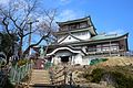
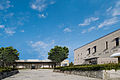
Komaki Castle museum

Ryūon-ji
(Mama Kannon)
Tagata Jinja

Komaki-shuku

Iwaya Kofun

Shinooka kiln ruins


- Parks
- Menard Art Museum
- Shimin Shiki no Mori
- Komaki Municipal Baseball Stadium
- Park Arena Komaki
Menard Art Museum
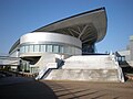
Park Arena Komaki

Komaki Municipal Baseball Stadium

Shimin Shiki no Mori


Festivals[]
- Hōnen Matsuri, and annual fertility festival held on March 15 at Tagata Shrine.[citation needed]
- Bamboo Installation

Hōnen Matsuri at Tagata Shrine in Komaki

Bamboo Installation


Noted people from Komaki[]
- Asuka Teramoto, Olympic gymnast
- Jōtarō Watanabe, Imperial Japanese Army general
- Minoru Tanaka, professional wrestler
- Miku Ishida, singer, gravure artist
- AK-69, hip-hop artist
- Kohei Hirate, professional race car driver
References[]
- ^ "Komaki City official statistics" (in Japanese).
- ^ Komaki population statistics
- ^ "Komaki climate data".
- ^ "Business Locations". Sumitomo Riko. Archived from the original on 12 November 2020. Retrieved 11 November 2020.
- ^ 市民所得 [Citizen Income] (PDF). Archived from the original (PDF) on 22 August 2018.
- ^ "Komaki Population (December 2014)". 1 December 2014.
- ^ "Escolas Brasileiras Homologadas no Japão" (Archive). Embassy of Brazil in Tokyo. February 7, 2008. Retrieved on October 13, 2015.
- ^ Peachliner home page (in Japanese)
- ^ "International Exchange". List of Affiliation Partners within Prefectures. Council of Local Authorities for International Relations (CLAIR). Archived from the original on 24 December 2015. Retrieved 21 November 2015.
External links[]
| Wikimedia Commons has media related to Komaki, Aichi. |
- Komaki City official website (in Japanese)
| show Authority control |
|---|
- Komaki
- Cities in Aichi Prefecture