Toyoake
Toyoake
豊明市 | |
|---|---|
 Okehazama Old Battlefield | |
 Flag  Seal | |
 Location of Toyoake in Aichi Prefecture | |
 Toyoake | |
| Coordinates: 35°03′3.1″N 137°0′46.2″E / 35.050861°N 137.012833°ECoordinates: 35°03′3.1″N 137°0′46.2″E / 35.050861°N 137.012833°E | |
| Country | Japan |
| Region | Chūbu (Tōkai) |
| Prefecture | Aichi |
| Government | |
| • Mayor | Hidekatsu Aiba |
| Area | |
| • Total | 23.22 km2 (8.97 sq mi) |
| Population (October 1, 2019) | |
| • Total | 69,525 |
| • Density | 3,000/km2 (7,800/sq mi) |
| Time zone | UTC+9 (Japan Standard Time) |
| - Tree | Zelkova |
| - Flower | Sunflower |
| Phone number | 0562-92-1111 |
| Address | 1-1 Komochimatsu, Shinden-chō, Toyoake-shi, Aichi-ken 470-1195 |
| Website | Official website |

Toyoake (豊明市, Toyoake-shi) is a city located in Aichi Prefecture, Japan. As of 1 October 2019, the city had an estimated population of 69,525 in 30,185 households,[1] and a population density of 2,994 persons per km². The total area of the city is 23.22 square kilometres (8.97 sq mi).
Geography[]
Toyoake is located in the coastal flatlands of central Aichi Prefecture, bordering the Nagoya metropolis.
Surrounding municipalities[]
| show Places adjacent to Toyoake |
|---|
Demographics[]
Per Japanese census data,[2] the population of Toyoake exploded during the 1970s and has continued to grow.
| Year | Pop. | ±% |
|---|---|---|
| 1920 | 6,402 | — |
| 1930 | 6,921 | +8.1% |
| 1940 | 7,872 | +13.7% |
| 1950 | 11,646 | +47.9% |
| 1960 | 15,366 | +31.9% |
| 1970 | 29,776 | +93.8% |
| 1980 | 54,667 | +83.6% |
| 1990 | 62,160 | +13.7% |
| 2000 | 66,495 | +7.0% |
| 2010 | 69,727 | +4.9% |
Climate[]
The city has a climate characterized by hot and humid summers, and relatively mild winters (Köppen climate classification Cfa). The average annual temperature in Toyoake is 15.6 °C. The average annual rainfall is 1586 mm with September as the wettest month. The temperatures are highest on average in August, at around 27.9 °C, and lowest in January, at around 4.3 °C.[3]
History[]
The area of modern Toyoake was part of Owari Province and was the location of many battles during the Sengoku period, one of them being the Battle of Okehazama. It was part of the holdings of Owari Domain under the Edo period Tokugawa shogunate. With the establishment of the modern municipalities system in 1888, Toyoake Village was created within Aichi District, Aichi. Toyoake became a town on January 1, 1951, and was elevated to city status on August 1, 1982.
Government[]
Toyoake has a mayor-council form of government with a directly elected mayor and a unicameral city legislature of 20 members. The city contributes one member to the Aichi Prefectural Assembly. In terms of national politics, the city is part of Aichi District 7 of the lower house of the Diet of Japan.
Economy[]
Due to its proximity to the Nagoya metropolis, Toyoake is largely a bedroom community with some light manufacturing and product distribution.
Education[]
Universities and Colleges[]
Primary and secondary schools[]
Toyoake has nine public elementary schools and three public junior high schools operated by the city government, and one public high schools operated by the Aichi Prefectural Board of Education. There is also one private junior high school and one private high school. The prefecture also operates one special education school for the handicapped.
International schools[]
North Korean:
Transportation[]
Railway[]
Highway[]
 Isewangan Expressway - Toyoake Interchange
 National Route 1
Sister city relations[]
Local attractions[]
Places[]
- Ano Ichirizuka, milestone markers on the old Tōkaidō, National Historic Site
- Ruins of Kutsukake Castle (沓掛城址)
- Okezazama Battlefield site, National Historic Site
- Chukyo Racecourse (中京競馬場)
Events[]
- Toyoake Haru-Matsuri (豊明春まつり)
- Toyoake Natsu-Matsuri (豊明夏まつり)
- Toyoake Matsuri (豊明まつり)
- Toyoake Marathon (とよあけマラソン)
Gallery[]

City hall

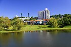
Toyoake city skyline

Nyakōji-ike pond
Nishi-ike pond & Nishiike park

Mount Futamura

Fire department
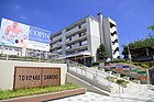
Toyoake Danchi

Cultural center

Toyoake city library
Ruins of Kutsukake castle

Chukyo Racecourse Main-stand PEGASUS

Fujita Health University Hospital

Zengo Station


Notable people from Toyoake[]
- Kimiyasu Kudoh, professional baseball player [5]
References[]
- ^ Toyoake City official statistics (in Japanese)
- ^ Toyoake population statistics
- ^ Toyoake climate data
- ^ "International Exchange". List of Affiliation Partners within Prefectures. Council of Local Authorities for International Relations (CLAIR). Retrieved 21 November 2015.
- ^ Kimiyasu Kudo
External links[]
| Wikimedia Commons has media related to Toyoake, Aichi. |
- Official website (in Japanese) (with link to pages in English)
| show Authority control |
|---|
- Toyoake, Aichi
- Cities in Aichi Prefecture