Konka (river)
| Konka | |
|---|---|
 | |
| Location | |
| Country | Ukraine |
| Physical characteristics | |
| Mouth | Dnieper |
• coordinates | 47°38′20″N 35°15′50″E / 47.6388°N 35.2640°ECoordinates: 47°38′20″N 35°15′50″E / 47.6388°N 35.2640°E |
| Length | 146 km (91 mi) |
| Basin size | 2,580 km2 (1,000 sq mi) |
| Basin features | |
| Progression | Dnieper→ Dnieper–Bug estuary→ Black Sea |
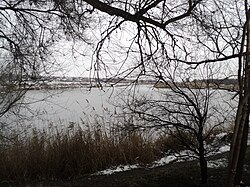
The Konka (Ukrainian: Конка, Кінські Води) is a left tributary of the Dnieper, flowing through the Zaporizhzhia Oblast. It is 146 kilometres (91 mi) long, and has a drainage basin of 2,580 square kilometres (1,000 sq mi).[1] Among cities that located on the river are Polohy, Orikhiv and others.
The name is a local adaptation of the Crimean Tatar name of the river Yilki Su which means a water of wild horses. At the mouth of the river was located a residence of Beylerbey Mamai.[2] In 18th century it served as a border between the Russian Empire and the Ottoman Empire.[3]
References[]
- ^ Конка, Great Soviet Encyclopedia
- ^ Ryzhkov, V. The Mamai's land. The ancient Ukraine and the Tatar-Mongolian Great Steppe (Мамаева земля. Древняя Украина и татаро-монгольская Великая Степь). Argument (from Den newspaper). 28 January 2017
- ^ Knyazkov, Yu. Kinska, Kinski vody, Kinka, Konka (КІНСЬКА, КІНСЬКІ ВОДИ, КІНКА, КОНКА). Encyclopedia of History of Ukraine.
External links[]
- Konka in the Great Soviet Encyclopedia
| Tributaries1 |  | |
|---|---|---|
| Reservoirs | ||
| Hydroelectric stations | ||
| Canals | ||
| Cities | ||
| Crossings | ||
| ||
This article about a location in Zaporizhzhia Oblast is a stub. You can help Wikipedia by . |
Categories:
- Tributaries of the Dnieper
- Rivers of Zaporizhzhia Oblast
- Zaporizhzhia Oblast geography stubs
- Ukraine river stubs