Konnevesi
Konnevesi | |
|---|---|
Municipality | |
| Konneveden kunta Konnevesi kommun | |
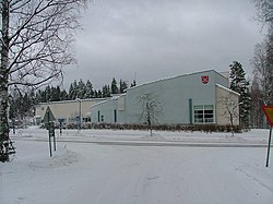 The municipal house of Konnevesi | |
 Coat of arms | |
 Location of Konnevesi in Finland | |
| Coordinates: 62°37.7′N 026°17′E / 62.6283°N 26.283°ECoordinates: 62°37.7′N 026°17′E / 62.6283°N 26.283°E | |
| Country | |
| Region | Central Finland |
| Sub-region | Äänekoski sub-region |
| Charter | 1922 |
| Government | |
| • Municipal manager | Kari Levänen |
| Area (2018-01-01)[1] | |
| • Total | 680.85 km2 (262.88 sq mi) |
| • Land | 513.01 km2 (198.07 sq mi) |
| • Water | 167.95 km2 (64.85 sq mi) |
| Area rank | 171st largest in Finland |
| Population (2021-03-31)[2] | |
| • Total | 2,569 |
| • Rank | 237th largest in Finland |
| • Density | 5.01/km2 (13.0/sq mi) |
| Population by native language | |
| • Finnish | 99.3% (official) |
| • Others | 0.6% |
| Population by age | |
| • 0 to 14 | 12.6% |
| • 15 to 64 | 53.1% |
| • 65 or older | 34.2% |
| Time zone | UTC+02:00 (EET) |
| • Summer (DST) | UTC+03:00 (EEST) |
| Municipal tax rate[5] | 22% |
| Website | www.konnevesi.fi |

Konnevesi is a municipality of Finland.
It is located in the former province of Western Finland and is part of the Central Finland region. The municipality has a population of 2,569 (31 March 2021)[2] and covers an area of 680.85 square kilometres (262.88 sq mi) of which 167.95 km2 (64.85 sq mi) is water.[1]
There are all together exactly 100 lakes in Konnevesi. The biggest lakes are Keitele, Lake Konnevesi and Liesvesi.[6] The population density is 5.01 inhabitants per square kilometre (13.0/sq mi).
Neighbouring municipalities are Hankasalmi, Laukaa, Rautalampi, Vesanto and Äänekoski.
The municipality is unilingually Finnish.
Villages[]
Hänniskylä, Hytölä, Istunmäki, Kärkkäiskylä (l. Kirkonkylä), Lummukka, Mäkäräniemi, Pukara, Pyhälahti, Rossinkylä, Siikakoski, Sirkkamäki, Särkisalo, Lahdenkylä, Pyydyskylä (l.Välimäki), Leskelänkylä, Jouhtikylä and Tankolampi.
Notable individuals[]
- , former soccer player
- Miika Lahti, ice hockey player
Gallery[]

Konnevesi Church

A windmill at Konnevesi Museum

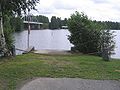
Lake Keitele in Konnevesi

Siikakoski rapid
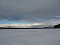
Frozen Lake Konnevesi
Kivisalmi bridge on the border of Konnevesi and Rautalampi


See also[]
References[]
- ^ Jump up to: a b "Area of Finnish Municipalities 1.1.2018" (PDF). National Land Survey of Finland. Retrieved 30 January 2018.
- ^ Jump up to: a b "Preliminary population structure by area, 2021M01*-2021M03*". StatFin (in Finnish). Statistics Finland. Retrieved 2 May 2021.
- ^ "Population according to language and the number of foreigners and land area km2 by area as of 31 December 2008". Statistics Finland's PX-Web databases. Statistics Finland. Retrieved 29 March 2009.
- ^ "Population according to age (1-year) and sex by area and the regional division of each statistical reference year, 2003-2020". StatFin. Statistics Finland. Retrieved 2 May 2021.
- ^ "List of municipal and parish tax rates in 2021" (PDF). Tax Administration of Finland. 1 December 2020. Retrieved 10 April 2021.
- ^ "Konnevesi". Järviwiki. Finland's Environmental Administration. 2012. Retrieved 27 February 2012.
External links[]
![]() Media related to Konnevesi at Wikimedia Commons
Media related to Konnevesi at Wikimedia Commons
- Municipality of Konnevesi – Official website (in Finnish)
| show Authority control |
|---|
This Western Finland location article is a stub. You can help Wikipedia by . |
- Konnevesi
- Populated places established in 1922
- Western Finland Province geography stubs