Pihtipudas
Pihtipudas | |
|---|---|
Municipality | |
| Pihtiputaan kunta Pihtipudas kommun | |
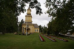 Pihtipudas Church | |
 Coat of arms | |
 Location of Pihtipudas in Finland | |
| Coordinates: 63°22′N 025°34.5′E / 63.367°N 25.5750°ECoordinates: 63°22′N 025°34.5′E / 63.367°N 25.5750°E | |
| Country | |
| Region | Central Finland |
| Sub-region | Saarijärvi–Viitasaari sub-region |
| Government | |
| • Municipal manager | Ari Kinnunen |
| Area (2018-01-01)[1] | |
| • Total | 1,247.48 km2 (481.65 sq mi) |
| • Land | 1,074.76 km2 (414.97 sq mi) |
| • Water | 172.71 km2 (66.68 sq mi) |
| Area rank | 72nd largest in Finland |
| Population (2021-03-31)[2] | |
| • Total | 3,918 |
| • Rank | 197th largest in Finland |
| • Density | 3.65/km2 (9.5/sq mi) |
| Population by native language | |
| • Finnish | 99.4% (official) |
| • Others | 0.6% |
| Population by age | |
| • 0 to 14 | 14.3% |
| • 15 to 64 | 53.1% |
| • 65 or older | 32.6% |
| Time zone | UTC+02:00 (EET) |
| • Summer (DST) | UTC+03:00 (EEST) |
| Municipal tax rate[5] | 21% |
| Website | www.pihtipudas.fi |

Pihtipudas is a municipality of Finland.
It is located in northern Central Finland along the highway 4 (E75), about 140 kilometres (90 mi) north of Jyväskylä. The municipality has a population of 3,918 (31 March 2021)[2] and covers an area of 1,247.48 square kilometres (481.65 sq mi) of which 172.71 km2 (66.68 sq mi) is water.[1] There are all together 140 lakes in Pihtipudas. Biggest lakes are , Muurasjärvi and Saanijärvi.[6] The population density is 3.65 inhabitants per square kilometre (9.5/sq mi).
The municipality is unilingually Finnish.
Pihtipudas is perhaps best known for the annual javelin carnival and Lauri "Tahko" Pihkala, the father of Finnish baseball. area offers plenty of services for travelers. Fish Art is a sales exhibition of taxidermic (mounted fish) – unique in Finland. Close to the service station there are shops – in a way factory outlets – specialized in sweets, leather bags and pottery products. Other tourist services are found in the central village and lakeside areas.
Attractions[]
The scenery and history of Pihtipudas are easy to be found hand in hand on the bridge of . Local museum and the church are next to each other in the center of Pihtipudas. Places worth mentioning are also area with well-known dancing place, an old demarcation Rillankivi and lake area.
Buildings and Structures[]
- 321 metres tall guyed TV-mast built in 1972
Twin towns[]
 Leirvík, Faroe Islands[7]
 Borgarbyggð/Borgarnes, Iceland[8]
 Ullensaker, Norway[9]
 Dragsholm, Denmark[10]
 Falkenberg, Sweden[11]
Gallery[]

Street in Pihtipudas

Pihtipudas Military Cemetery

Interior of Pihtipudas Church
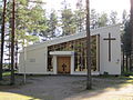
Muurasjärvi Church
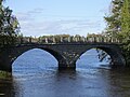
Heinäjoki Bridge


References[]
- ^ Jump up to: a b "Area of Finnish Municipalities 1.1.2018" (PDF). National Land Survey of Finland. Retrieved 30 January 2018.
- ^ Jump up to: a b "Preliminary population structure by area, 2021M01*-2021M03*". StatFin (in Finnish). Statistics Finland. Retrieved 2 May 2021.
- ^ "Population according to language and the number of foreigners and land area km2 by area as of 31 December 2008". Statistics Finland's PX-Web databases. Statistics Finland. Retrieved 29 March 2009.
- ^ "Population according to age (1-year) and sex by area and the regional division of each statistical reference year, 2003-2020". StatFin. Statistics Finland. Retrieved 2 May 2021.
- ^ "List of municipal and parish tax rates in 2021" (PDF). Tax Administration of Finland. 1 December 2020. Retrieved 10 April 2021.
- ^ "Pihtipudas)". Järviwiki. Finland's Environmental Administration. 2012. Retrieved 27 February 2012.
- ^ "Ystäväkuntalista" (PDF) (in Finnish). Pohjola-Norden. Retrieved 7 May 2012.[permanent dead link]
- ^ "Vennskapskommune samarbeide i Norden" (in Icelandic). Borgarbyggð Municipality. Archived from the original on 17 February 2012. Retrieved 7 May 2012.
- ^ "Ystäväkuntalista" (PDF) (in Finnish). Pohjola-Norden. Retrieved 7 May 2012.[permanent dead link]
- ^ "Ystäväkuntalista" (PDF) (in Finnish). Pohjola-Norden. Retrieved 7 May 2012.[permanent dead link]
- ^ "Ystäväkuntalista" (PDF) (in Finnish). Pohjola-Norden. Retrieved 7 May 2012.[permanent dead link]
External links[]
![]() Media related to Pihtipudas at Wikimedia Commons
Media related to Pihtipudas at Wikimedia Commons
- Municipality of Pihtipudas – Official website, finnish, english
| show Authority control |
|---|
This Western Finland location article is a stub. You can help Wikipedia by . |
- Pihtipudas
- Western Finland Province geography stubs