Kosan County
Kosan County
고산군 | |
|---|---|
| Korean transcription(s) | |
| • Chosŏn'gŭl | 고산군 |
| • Hancha | 高山郡 |
| • McCune-Reischauer | Kosan-gun |
| • Revised Romanization | Gosan-gun |
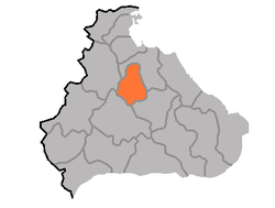 Map of Kangwon showing the location of Kosan | |
| Coordinates: 38°54′10.01″N 127°25′26.00″E / 38.9027806°N 127.4238889°ECoordinates: 38°54′10.01″N 127°25′26.00″E / 38.9027806°N 127.4238889°E | |
| Country | North Korea |
| Province | Kangwŏn Province |
| Administrative divisions | 1 ŭp, 24 ri |
| Area | |
| • Total | 435 km2 (168 sq mi) |
| Population (2008[1]) | |
| • Total | 103,579 |
| • Density | 240/km2 (620/sq mi) |

Kosan County is a kun, or county, in Kangwŏn province, North Korea.
Physical features[]
The county is largely mountainous. The central area forms a basin. The county's highest point is . Major streams include the , , and . There are a total of 13 reservoirs. Forestland makes up some 63.8% of the county's area.
Administrative divisions[]
Kosan county is divided into 1 ŭp (town) and 24 ri (villages):
|
|
Economy[]
Agriculture[]
Agriculture dominates local industry in Kosan, with crops including rice, maize, millet, wheat, barley, soybeans, and red beans. The region is particularly noted for its abundant production of fruit.
Mining[]
Mining is widely developed, exploiting the local deposits of gold, silver, copper, iron, limestone, lead, zinc, gypsum, and other minerals.
Transport[]
Kosan county is served by the Kangwŏn Line of the Korean State Railway.
See also[]
References[]
External links[]
- (in Korean) In Korean language online encyclopedias:

- Counties of Kangwon Province (North Korea)