Kostolec
Kostolec | |
|---|---|
Municipality | |
 | |
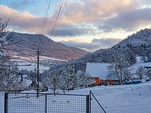
 Kostolec Location of Kostolec in the Trenčín Region | |
| Coordinates: 49°08′N 18°32′E / 49.133°N 18.533°ECoordinates: 49°08′N 18°32′E / 49.133°N 18.533°E | |
| Country | Slovakia |
| Region | Trenčín |
| District | Považská Bystrica |
| First mentioned | 1430 |
| Area | |
| • Total | 4.001 km2 (1.545 sq mi) |
| Elevation | 495 m (1,624 ft) |
| Population | |
| • Total | 256 |
| • Density | 64/km2 (170/sq mi) |
| Postal code | 017 05 (pošta Považská Bystrica 5) |
| Area code(s) | 421-42 |
| Car plate | PB |
| Website | www.kostolec.sk |


Kostolec (Hungarian: Kosfalu) is a village and municipality in Považská Bystrica District in the Trenčín Region of north-western Slovakia.
History[]
In historical records the village was first mentioned in 1430.
Geography[]
The municipality lies at an altitude of 495 metres and covers an area of 4.001 km². It has a population of about 256 people.
Genealogical resources[]
The records for genealogical research are available at the state archive "Statny Archiv in Bytca, Slovakia"
- Roman Catholic church records (births/marriages/deaths): 1764-1895 (parish B)
- Lutheran church records (births/marriages/deaths): 1801-1907 (parish B)
See also[]
External links[]
![]() Media related to Kostolec at Wikimedia Commons
Media related to Kostolec at Wikimedia Commons
- Official website

- https://web.archive.org/web/20090412234949/http://www.statistics.sk/mosmis/eng/run.html
- Surnames of living people in Kostolec
Municipalities of Považská Bystrica District | ||
|---|---|---|
This Trenčín District location article is a stub. You can help Wikipedia by . |
Categories:
- Villages and municipalities in Považská Bystrica District
- Trenčín geography stubs