Kotelniki
Kotelniki
Котельники | |
|---|---|
Town[1] | |
 Flag  Coat of arms | |
show Location of Kotelniki | |
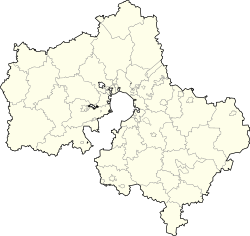 Kotelniki Location of Kotelniki | |
| Coordinates: 55°39′N 37°51′E / 55.650°N 37.850°ECoordinates: 55°39′N 37°51′E / 55.650°N 37.850°E | |
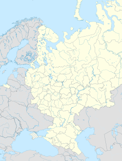
| Country | Russia |
| Federal subject | Moscow Oblast[1] |
| First mentioned | 17th century |
| Town status since | 2004 |
| Elevation | 140 m (460 ft) |
| Population | |
| • Total | 32,338 |
| • Estimate (2018)[3] | 44,869 (+38.8%) |
Administrative status | |
| • Subordinated to | Kotelniki Town Under Oblast Jurisdiction[1] |
| • Capital of | Kotelniki Town Under Oblast Jurisdiction[1] |
Municipal status | |
| • Urban okrug | Kotelniki Urban Okrug[4] |
| • Capital of | Kotelniki Urban Okrug[4] |
| Time zone | UTC+3 (MSK |
| Postal code(s)[6] | 140053–140054 |
| OKTMO ID | 46739000001 |


Kotelniki (Russian: Котéльники) is a town of Moscow Oblast, Russia, located 22 kilometers (14 mi) southeast of the center of Moscow. Population: 32,338 (2010 Census);[2] 17,747 (2002 Census);[7] 17,456 (1989 Census).[8]
History[]
The village of Kotelniki was first mentioned in the 17th century and belonged to Golitsyns in the 19th century.[citation needed] It was granted town status in 2004.[citation needed]
Administrative and municipal status[]
Within the framework of administrative divisions, it is incorporated as Kotelniki Town Under Oblast Jurisdiction—an administrative unit with the status equal to that of the districts.[1] As a municipal division, Kotelniki Town Under Oblast Jurisdiction is incorporated as Kotelniki Urban Okrug.[4]
Economy[]

Transportation[]
Kotelniki metro station, the terminus of the Moscow Metro's Tagansko-Krasnopresnenskaya Line, is located in the city. It was opened on 21 September 2015 and became the second station of the Moscow Metro in Moscow Oblast after Myakinino.[9]
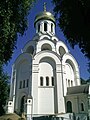
Gallery[]

Belaya Dacha estate

Church of the Theotokos of Kazan
Temple of Martyr Victor of Damascus


References[]
Notes[]
- ^ Jump up to: a b c d e Law #11/2013-OZ
- ^ Jump up to: a b Russian Federal State Statistics Service (2011). Всероссийская перепись населения 2010 года. Том 1 [2010 All-Russian Population Census, vol. 1]. Всероссийская перепись населения 2010 года [2010 All-Russia Population Census] (in Russian). Federal State Statistics Service.
- ^ "26. Численность постоянного населения Российской Федерации по муниципальным образованиям на 1 января 2018 года". Federal State Statistics Service. Retrieved January 23, 2019.
- ^ Jump up to: a b c Law #160/2004-OZ
- ^ "Об исчислении времени". Официальный интернет-портал правовой информации (in Russian). June 3, 2011. Retrieved January 19, 2019.
- ^ Почта России. Информационно-вычислительный центр ОАСУ РПО. (Russian Post). Поиск объектов почтовой связи (Postal Objects Search) (in Russian)
- ^ Russian Federal State Statistics Service (May 21, 2004). Численность населения России, субъектов Российской Федерации в составе федеральных округов, районов, городских поселений, сельских населённых пунктов – районных центров и сельских населённых пунктов с населением 3 тысячи и более человек [Population of Russia, Its Federal Districts, Federal Subjects, Districts, Urban Localities, Rural Localities—Administrative Centers, and Rural Localities with Population of Over 3,000] (XLS). Всероссийская перепись населения 2002 года [All-Russia Population Census of 2002] (in Russian).
- ^ Всесоюзная перепись населения 1989 г. Численность наличного населения союзных и автономных республик, автономных областей и округов, краёв, областей, районов, городских поселений и сёл-райцентров [All Union Population Census of 1989: Present Population of Union and Autonomous Republics, Autonomous Oblasts and Okrugs, Krais, Oblasts, Districts, Urban Settlements, and Villages Serving as District Administrative Centers]. Всесоюзная перепись населения 1989 года [All-Union Population Census of 1989] (in Russian). Институт демографии Национального исследовательского университета: Высшая школа экономики [Institute of Demography at the National Research University: Higher School of Economics]. 1989 – via Demoscope Weekly.
- ^ Котельники (in Russian). Андрей Суриков. Retrieved November 10, 2013.
Sources[]
- Московская областная Дума. Закон №11/2013-ОЗ от 31 января 2013 г. «Об административно-территориальном устройстве Московской области», в ред. Закона №249/2019-ОЗ от 29 ноября 2019 г. «О внесении изменений в Закон Московской области "Об административно-территориальном устройстве Московской области"». Вступил в силу на следующий день после официального опубликования (13 января 2013 г.). Опубликован: "Ежедневные Новости. Подмосковье", №24, 12 февраля 2013 г. (Moscow Oblast Duma. Law #11/2013-OZ of January 31, 2013 On the Administrative-Territorial Structure of Moscow Oblast, as amended by the Law #249/2019-OZ of November 29, 2019 On amending the Law of Moscow Oblast "On the Administrative-Territorial Structure of Moscow Oblast". Effective as of the day following the day of the official publication (January 13, 2013).).
- Московская областная Дума. Закон №160/2004-ОЗ от 25 ноября 2004 г. «О статусе и границе городского округа Котельники», в ред. Закона №34/2012-ОЗ от 18 апреля 2012 г «О внесении изменений в Закон Московской области "О статусе и границе городского округа Котельники"». Вступил в силу со дня официального опубликования. Опубликован: "Ежедневные Новости. Подмосковье", №231, 4 декабря 2004 г. (Moscow Oblast Duma. Law #160/2004-OZ of November 25, 2004 On the Status and the Border of Kotelniki Urban Okrug, as amended by the Law #34/2012-OZ of April 18, 2012 On Amending the Law of Moscow Oblast "On the Status and the Border of Kotelniki Urban Okrug". Effective as of the day of the official publication.).
| Authority control |
|
|---|
- Cities and towns in Moscow Oblast