Koulikoro
Koulikoro | |
|---|---|
Commune and town | |
 View over Koulikoro | |
 Koulikoro Location within Mali | |
| Coordinates: 12°51′40″N 7°33′30″W / 12.86111°N 7.55833°WCoordinates: 12°51′40″N 7°33′30″W / 12.86111°N 7.55833°W | |
| Country | |
| Region | Koulikoro |
| Cercle | Koulikoro Cercle |
| Urban Commune | Koulikoro |
| Population (2009 census)[1] | |
| • Total | 43,174 |
| Time zone | UTC+0 (GMT) |

Koulikoro (Bambara: ߞߎߟߌߞߏߙߏ tr. Kulikoro) is a town and urban commune in Mali. The capital of the Koulikoro Region, Koulikoro is located on banks of the Niger River, 59 kilometres (37 mi) downstream from Mali's capital Bamako.
Koulikoro is the terminus of the Dakar-Niger Railway which was completed in 1904.[2] Between August and November, at the end of the rainy season, goods are transported down the Niger River to Ségou, Mopti, Tombouctou and Gao. Navigation is not possible upstream of Koulikoro because of the Sotuba Rapids near Bamako.
Gallery[]
- Historical images of Koulikoro

Arrival of the Hourst mission, 1898.
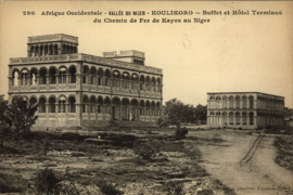
Hotel

The town's market.


Sister cities[]
References[]
- ^ Resultats Provisoires RGPH 2009 (Région de Koulikoro) (PDF) (in French), République de Mali: Institut National de la Statistique.
- ^ Clozel, François-Joseph (1912). Haut--Sénégal--Niger (Soudan franc̜ais): séries d'etudes pub. sous la direction de M. le gouverneur Clozel. E. Larose. p. 72.
- ^ Jump up to: a b "Verein für Städtepartnerschaft und Zusammenarbeit Bous e.V." (in German). Retrieved 2014-03-16.
External links[]
- Plan de Sécurité Alimentaire Commune Urbaine de Koulikoro 2008-2012 (PDF) (in French), Commissariat à la Sécurité Alimentaire, République du Mali, USAID-Mali, 2008, archived from the original (PDF) on 2012-05-06.
 Koulikoro (city) travel guide from Wikivoyage
| Wikimedia Commons has media related to Koulikoro. |

| show Authority control |
|---|
Categories:
- Koulikoro
- Communes of Koulikoro Region
- Regional capitals in Mali
- Communities on the Niger River