Krasnaya Polyana, Sochi, Krasnodar Krai
Krasnaya Polyana
Красная Поляна | |
|---|---|
Urban-type settlement | |
 General view of the Krasnaya Polyana from the Psekhako Ridge. In the foreground is a mountain Olympic village. | |
show Location of Krasnaya Polyana | |
 Krasnaya Polyana Location of Krasnaya Polyana | |
| Coordinates: 43°40′43″N 40°12′19″E / 43.67861°N 40.20528°ECoordinates: 43°40′43″N 40°12′19″E / 43.67861°N 40.20528°E | |
| Country | Russia |
| Federal subject | Krasnodar Krai |
| Settlement okrug | Krasnopolyansky Settlement Okrug |
| Founded | 1869 |
| Urban-type settlement status since | 1950 |
| Elevation | 533 m (1,749 ft) |
| Population | |
| • Total | 4,598 |
| • Estimate (2018)[2] | 4,789 (+4.2%) |
Administrative status | |
| • Subordinated to | City of Sochi |
| • Capital of | Krasnopolyansky Settlement Okrug |
Municipal status | |
| • Urban okrug | Sochi Urban Okrug |
| Time zone | UTC+3 (MSK |
| Postal code(s)[4] | 354392 |
| Dialing code(s) | +7 8622[5] |
| OKTMO ID | 03726000056 |


Krasnaya Polyana (Russian: Кра́сная Поля́на, IPA: [ˈkrasnəjə pɐˈlʲanə]; Abkhazian: Гәбаадәы, Gwbaadwy; Adyghe: Ӏаткъуадж, ‘atquaj) is an urban locality (an urban-type settlement) in Krasnopolyansky Settlement Okrug, which is under the administrative jurisdiction of Adlersky City District of the City of Sochi in Krasnodar Krai, Russia. Population: 4,598 (2010 Census);[1] 3,969 (2002 Census);[6] 3,300 (1989 Census).[7]
Located in the Western Caucasus, it is home to the new Rosa Khutor alpine ski resort, with a base elevation of 560 meters (1,840 ft) along the Mzymta River, 39 kilometers (24 mi) from its influx into the Black Sea in Adlersky City District of Sochi. The lift-served summit climbs to 2,320 meters (7,610 ft), giving a vertical drop of over a mile at 1,760 meters (5,770 ft). The resort hosted the Alpine and Nordic events of the 2014 Winter Olympics in Sochi, having previously hosted World Cup alpine events from February 2012, two years earlier and is also where the ashes of Canadian skier Sarah Burke were spread.[citation needed]
Etymology[]
The name "Krasnaya Polyana" (lit. Red Glade) was given by the Greek settlers in 1878 because of the thick overgrowth of fern, the leaves of which had a reddish-brown color in fall.[8] Walter Richmond, a historian of the Circassian genocide notes that Krasnaya Polyana was named after the last stand by the Circassian Ubykhs, of whom many died there in 1864.[9]
History[]
Although the vicinity is rich in prehistoric dolmens and contains ruins of about twenty medieval forts, the settlement first appears in recorded history in 1835, when a Russian spy, Baron , visited the Sadz Abkhazian village of Artquaj in the guise of a Circassian mountaineer. Having spent several days in the village, he recorded his observations in a journal. Among other things, Tornau noted that the village was famous for its honey which was exported by the Sadz people to the Ottoman Empire.
By the 1860s, the village was known as Kbaade and became populated with the Akhchipsou branch of the Sadz. In 1864, the area was the scene, significant in Circassian history, of the last battles of the Russian–Circassian War. The area was conquered by four main Russian armies and the end of the prolonged Caucasian War declared (on June 2, 1864). The area became a part of the Russian Empire and those residents who did not swear allegiance to the Empire were removed to the Ottoman Empire. The abandoned aul was replaced with the new settlement of Krasnaya Polyana in 1869. The new settlers were ethnically diverse, including not only Russians, but also Greeks from Stavropol and Estonians, who colonized Estosadok, now a ski resort 4 kilometers (2.5 mi) upstream on the Mzymta.
On June 19, 1899, Krasnaya Polyana was visited by an official commission under , with a view to transforming it into Tsarskaya Polyana, Nicholas II's hunting ground in the Western Caucasus. A royal hunting lodge was erected in 1901, followed by the chalets of Counts Sheremetev and Bobrinsky, among other nobles and high-placed dignitaries. Although it was never visited by the Tsar, the village was renamed Romanovsk (Романовск), after the ruling imperial dynasty. A winding mountain road to Adler was inaugurated in 1898.
Following the October Revolution of 1917, the exclusive retreat reverted to its former name and status and gradually dwindled into obscurity. The proximity to Sochi, the "summer capital" of Russia, eventually revived its fortunes in the last quarter of the 20th century, when it achieved a modicum of popularity across the former Soviet Union, despite limited hotel capabilities and installations, and difficulty of access through narrow mountain passes.
The loss of ski areas in South Caucasus and Tian Shan after the dissolution of the Soviet Union increased Krasnaya Polyana's prestige and importance for Russia's elites. By the 21st century, the locality had emerged as one of the most sought after ski resorts in the country. This is the favorite skiing area of Russian President Vladimir Putin, who can easily reach Krasnaya Polyana by helicopter from his country residence of Bocharov Ruchey near Dagomys.
Climate[]
| hideClimate data for Sochi | |||||||||||||
|---|---|---|---|---|---|---|---|---|---|---|---|---|---|
| Month | Jan | Feb | Mar | Apr | May | Jun | Jul | Aug | Sep | Oct | Nov | Dec | Year |
| Average high °C (°F) | 3 (37) |
5 (41) |
11 (52) |
18 (64) |
22 (72) |
26 (79) |
30 (86) |
30 (86) |
24 (75) |
18 (64) |
10 (50) |
4 (39) |
17 (62) |
| Average low °C (°F) | −5 (23) |
−4 (25) |
1 (34) |
6 (43) |
10 (50) |
15 (59) |
17 (63) |
17 (63) |
12 (54) |
7 (45) |
1 (34) |
−3 (27) |
6 (43) |
| Average precipitation mm (inches) | 36 (1.4) |
24 (0.9) |
25 (1.0) |
38 (1.5) |
63 (2.5) |
67 (2.6) |
36 (1.4) |
39 (1.5) |
37 (1.5) |
33 (1.3) |
40 (1.6) |
34 (1.3) |
472 (18.5) |
| Average precipitation days | 10 | 6 | 7 | 8 | 9 | 9 | 6 | 6 | 7 | 8 | 8 | 9 | 93 |
| Source: worldweatheronline | |||||||||||||
Location and facilities[]


Krasnaya Polyana is sited against the scenic backdrop of the Caucasus Mountains, which exceed 2,000 meters (6,600 ft) in elevation, at a distance of 67 kilometers (42 mi) from the center of Sochi by road and 40 kilometers (25 mi) from the Adler-Sochi International Airport. The settlement has been plagued by transport problems: in order to improve this for the 2014 Winter Olympics, a railway line was built, connecting the area with the airport, Sochi Olympic Village, and central Sochi.
Krasnaya Polyana today offers many chalets, hotels, and restaurants. Its reputation owes a lot to the development of heliskiing in the middle of the 1990s, which provides access to an important skiing domain. Amateurs can ski downhill through a not-too-dense birch forest, with a vertical drop of 1,760 meters (5,770 ft). The station at Rosa Khutor has four chairlifts (lowest station at 560 meters (1,840 ft) and upper station at 2,320 meters (7,610 ft)) and 12 kilometers (7.5 mi) of delimited tracks. As of 2006, the Alpika Service was being developed by the Gazprom.
Structures[]
- An electricity pylon looking like a snow leopard [1].
Economy[]
The economic activity in the village is based on serving tourists and visitors in winter and summer. Krasnaya Polyana is a popular skiing and snowboarding center with the reputation of being the most "respectable" in Russia. The ski slopes around the village are known for good snow cover thanks to the humid air. The terrain provides good opportunities for off-piste skiing. The best time to visit Krasnaya Polyana as a ski resort is from December to March. Sometimes the season starts as early as November and ends in early May.
The gambling zone is Krasnaya Polyana was created in August 2016. Ite is located in the Sochi mountain cluster on land plots with an area of 165 thousand square meters, previously provided for the location of Olympic facilities, financing and construction of which was carried out not at the expense of budget funds or funds of the state corporation Olympstroy, but by private investors.
2014 Olympics venues[]

- Sanki Sliding Center, luge, bobsled, and skeleton (moved to Rzhanaya Polyana in May 2009)
- Laura Cross-Country ski and Biathlon Center, biathlon, cross-country skiing, and Nordic combined
- Rosa Khutor Alpine Resort, alpine skiing
- Rosa Khutor Extreme Park, freestyle skiing, snowboarding
- RusSki Gorki Jumping Center, ski jumping and Nordic combined
References[]
- ^ Jump up to: a b Russian Federal State Statistics Service (2011). Всероссийская перепись населения 2010 года. Том 1 [2010 All-Russian Population Census, vol. 1]. Всероссийская перепись населения 2010 года [2010 All-Russia Population Census] (in Russian). Federal State Statistics Service.
- ^ "26. Численность постоянного населения Российской Федерации по муниципальным образованиям на 1 января 2018 года". Federal State Statistics Service. Retrieved January 23, 2019.
- ^ "Об исчислении времени". Официальный интернет-портал правовой информации (in Russian). June 3, 2011. Retrieved January 19, 2019.
- ^ Почта России. Информационно-вычислительный центр ОАСУ РПО. (Russian Post). Поиск объектов почтовой связи (Postal Objects Search) (in Russian)
- ^ (Worldwide Phone Codes)
- ^ Russian Federal State Statistics Service (May 21, 2004). Численность населения России, субъектов Российской Федерации в составе федеральных округов, районов, городских поселений, сельских населённых пунктов – районных центров и сельских населённых пунктов с населением 3 тысячи и более человек [Population of Russia, Its Federal Districts, Federal Subjects, Districts, Urban Localities, Rural Localities—Administrative Centers, and Rural Localities with Population of Over 3,000] (XLS). Всероссийская перепись населения 2002 года [All-Russia Population Census of 2002] (in Russian).
- ^ Всесоюзная перепись населения 1989 г. Численность наличного населения союзных и автономных республик, автономных областей и округов, краёв, областей, районов, городских поселений и сёл-райцентров [All Union Population Census of 1989: Present Population of Union and Autonomous Republics, Autonomous Oblasts and Okrugs, Krais, Oblasts, Districts, Urban Settlements, and Villages Serving as District Administrative Centers]. Всесоюзная перепись населения 1989 года [All-Union Population Census of 1989] (in Russian). Институт демографии Национального исследовательского университета: Высшая школа экономики [Institute of Demography at the National Research University: Higher School of Economics]. 1989 – via Demoscope Weekly.
- ^ "Знай свой край. Словарь географических названий Краснодарского края." Составитель: И. П. Лотышев. Краснодарское книжное издательство, 1974.
- ^ Walter Richmond, The Circassian Genocide, Introduction, Kindle location 36
- ^ Guidebook "Sochi Olympic Games" by Federal Agency for tourism
- (in Russian) History of Krasnaya Polyana on the Alpika Service website
- (in Russian) Article about Krasnaya Polyana in the Sankt-Peterburgskiye Vedomosti

Cable car

Gorki Gorod and Gornaya Karusel

Ski-biathlon complex Laura on the Psekhako Ridge
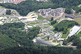
Sledge-bobsleigh track

Summer at Krasnaya Polyana


External links[]
| Wikimedia Commons has media related to Krasnaya Polyana. |
| Wikivoyage has a travel guide for Krasnaya Polyana. |
- (in German) Krasnaya Polyana
- (in Russian) Красная Поляна
- (in Swedish) Krasnaya Polyana photos
- (in French and English) Krasnaya Polyana tourist information
| hide Territorial divisions of Sochi | ||
|---|---|---|
| 1 Tsentralny City District |
|  |
| 2 Khostinsky City District |
| |
| 3 Lazarevsky City District |
| |
| 4 Adlersky City District |
| |
| show Authority control |
|---|
- Urban-type settlements in Krasnodar Krai
- Adlersky City District
- Venues of the 2014 Winter Olympics
- Ski areas and resorts in Russia