Kuinre
Kuinre | |
|---|---|
Village | |
 Skyline of Kuinre | |
 Coat of arms | |
| Coordinates: 52°47′11″N 5°50′36″E / 52.78639°N 5.84333°E | |
| Country | Netherlands |
| Province | Overijssel |
| Municipality | Steenwijkerland |

Kuinre (Low Saxon: De Kuunder) is a village in the Dutch province of Overijssel. It was a separate municipality until 1973, when it became a part of IJsselham, which in turn merged into the municipality of Steenwijkerland in 2001.[1]
Kuinre is a formerly coastal town with a very rich history. Back in the days of the Zuiderzee, Kuinre's harbour was one of the most important ports of the Zuiderzee. After completion of the Noordoostpolder Kuinre became landlocked; companies, shops, and fishermen went out of business.
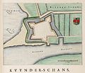
fort Kynder - Atlas van Loon (1649)

Waag
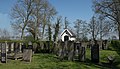
General Cemetery


References[]
- ^ Ad van der Meer and Onno Boonstra, Repertorium van Nederlandse gemeenten, KNAW, 2011.
External links[]
- J. Kuyper, Gemeente Atlas van Nederland, 1865-1870, "Kuinre". Map of the former municipality, around 1868.
| hide Authority control | |
|---|---|
| General |
|
| National libraries | |
Coordinates: 52°47′N 5°50′E / 52.783°N 5.833°E
This Overijssel location article is a stub. You can help Wikipedia by . |
Categories:
- Populated places in Overijssel
- Former municipalities of Overijssel
- Steenwijkerland
- Overijssel geography stubs