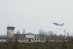
Kuressaare Airport
Kuressaare Airport Kuressaare lennujaam | |||||||||||||||
|---|---|---|---|---|---|---|---|---|---|---|---|---|---|---|---|
 | |||||||||||||||
| Summary | |||||||||||||||
| Airport type | Public | ||||||||||||||
| Operator | Kuressaare Lennujaam | ||||||||||||||
| Serves | Kuressaare, Estonia | ||||||||||||||
| Elevation AMSL | 14[1] ft / 4 m | ||||||||||||||
| Coordinates | 58°13′48″N 022°30′34″E / 58.23000°N 22.50944°ECoordinates: 58°13′48″N 022°30′34″E / 58.23000°N 22.50944°E | ||||||||||||||
| Website | www.kuressaare-airport.ee | ||||||||||||||
| Map | |||||||||||||||
 EEKE Location in Europe | |||||||||||||||
| Runways | |||||||||||||||
| |||||||||||||||
| Statistics (2019) | |||||||||||||||
| |||||||||||||||
Sources: Estonian AIP[2] | |||||||||||||||


Kuressaare Airport (Estonian: Kuressaare lennujaam, IATA: URE, ICAO: EEKE) is an airport in Estonia. The airport is situated 1.5 nautical miles (2.8 km; 1.7 mi) south southeast[2] of Kuressaare on Saaremaa island.
Overview[]
The first runway was built in the last half of the 1930s. The airport was opened officially on 6 March 1945. The air traffic increased during the proceeding years and between 1949 and 1953 there were between 10 and 14 daily flights between Kuressaare and Tallinn. During this period, around 400 passengers flew to or from Kuressaare daily. The airport did not get electricity until 1958. The present terminal building was built in 1962. The second runway 05/23 was built in 1976 and in 1999 the main runway was lengthened. The terminal building was modernized in 2007.
The airport is owned by AS Tallinna Lennujaam. It also owns Ruhnu Airfield.
19,702 passengers travelled via Kuressaare Airport in 2010.
Airlines and destinations[]
| Airlines | Destinations |
|---|---|
| Ruhnu | |
| Tallinn (PSO) |
Statistics[]
References[]
- ^ Kuressaare Airport at worldaerodata.com
- ^ a b "eAIP Estonia". Estonian Air Navigation Services (ANS). Archived from the original on 2016-10-26. Retrieved 2016-07-27.
External links[]
This article about an Estonian building or structure is a stub. You can help Wikipedia by . |
This article about a European airport is a stub. You can help Wikipedia by . |
This article about transport in Estonia is a stub. You can help Wikipedia by . |
- Airports in Estonia
- Airports built in the Soviet Union
- Buildings and structures in Saaremaa
- 1940s establishments in Estonia
- Kuressaare
- Airports established in 1945
- Estonian building and structure stubs
- European airport stubs
- Europe transport stubs
- Estonia transport stubs