Kurima-jima
This article needs additional citations for verification. (January 2021) |
Native name: Japanese: 来間島 | |
|---|---|
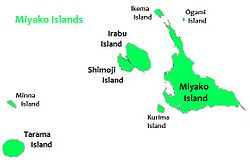 Kurima-jima is located 1.5 km southwest of Miyako-jima | |
 Kurima Island | |
| Geography | |
| Location | Okinawa Prefecture |
| Coordinates | 24°43′20.47″N 125°14′49.10″E / 24.7223528°N 125.2469722°E |
| Archipelago | Miyako Islands |
| Area | 2.84 km2 (1.10 sq mi)[1] |
| Administration | |
Japan | |
| Okinawa Prefecture | |
| Demographics | |
| Population | 161 (2015 national census)[1] |
| Ethnic groups | Ryukyuan, Japanese |

Kurima Island (来間島, Kurima-jima), (Miyako: Ffyama) is one of the Miyako Islands of Okinawa Prefecture, Japan. It is connected to Miyako-jima via 1,690m Kurima Bridge (来間大橋).[1][2]
Gallery[]
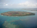
Kurima-jima

Bridge from Kurima-jima to Miyako-jima

Beach on Kurima island


See also[]
References[]
- ^ Jump up to: a b c "Remote island related materials (離 島 関 係 資 料)" (PDF). Archived (PDF) from the original on 15 February 2020. Retrieved 15 February 2020.
- ^ "Kurima-ohashi Bridge | Miyakojima | Japan Travel Guide - Japan Hoppers".
External links[]
| Wikimedia Commons has media related to Kurima Island. |
| Wikivoyage has a travel guide for Miyako Islands. |
| show Authority control |
|---|
This Okinawa Prefecture location article is a stub. You can help Wikipedia by . |
Categories:
- Miyako Islands
- Islands of Okinawa Prefecture
- Okinawa geography stubs