Kynšperk nad Ohří
Kynšperk nad Ohří | |
|---|---|
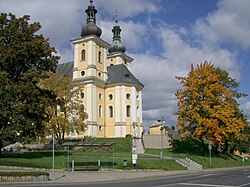 Church of the Assumption of the Virgin Mary | |
 Flag  Coat of arms | |
 Kynšperk nad Ohří Location in the Czech Republic | |
| Coordinates: 50°7′8″N 12°31′59″E / 50.11889°N 12.53306°ECoordinates: 50°7′8″N 12°31′59″E / 50.11889°N 12.53306°E | |
| Country | |
| Region | Karlovy Vary |
| District | Sokolov |
| Founded | 1232 |
| Government | |
| • Mayor | Tomáš Svoboda (ČSSD) |
| Area | |
| • Total | 23.31 km2 (9.00 sq mi) |
| Elevation | 431 m (1,414 ft) |
| Population (2021-01-01)[1] | |
| • Total | 4,739 |
| • Density | 200/km2 (530/sq mi) |
| Time zone | UTC+1 (CET) |
| • Summer (DST) | UTC+2 (CEST) |
| Postal codes | 357 51, 358 01 |
| Website | www |

Kynšperk nad Ohří (Czech pronunciation: [ˈkɪnʃpɛrk ˈnat oɦr̝iː]; German: Königsberg an der Eger) is a town in Sokolov District in the Karlovy Vary Region of the Czech Republic. It has about 4,700 inhabitants. It lies on the Ohře River.
Administrative parts[]
Villages of Chotíkov, Dolní Pochlovice, Dvorečky, Kamenný Dvůr, Liboc, Štědrá and Zlatá are administrative parts of Kynšperk nad Ohří.
History[]
The town was founded in 1232. The town's founding charter is the oldest preserved document of establishing a locality in the Czech Republic and is stored in the National Archives in Prague.[2]
Notable people[]
- Caspar Buberl (1834–1899), American sculptor
Twin towns – sister cities[]
Kynšperk nad Ohří is twinned with:[3]
 Himmelkron, Germany
References[]
- ^ "Population of Municipalities – 1 January 2021". Czech Statistical Office. 2021-04-30.
- ^ "Zakládací listina". kynsperk.cz (in Czech). Město Kynšperk nad Ohří. Retrieved 2020-07-27.
- ^ "Partnerské město Himmelkron". kynsperk.cz (in Czech). Město Kynšperk nad Ohří. Retrieved 2020-07-24.
External links[]
| Wikimedia Commons has media related to Kynšperk nad Ohří. |
- Official website (in Czech)
| show Authority control |
|---|
This Karlovy Vary Region location article is a stub. You can help Wikipedia by . |
Categories:
- Populated places in Sokolov District
- Cities and towns in the Czech Republic
- Karlovy Vary Region geography stubs