La Chapelle-Saint-Luc
show This article may be expanded with text translated from the corresponding article in French. (December 2008) Click [show] for important translation instructions. |
La Chapelle-Saint-Luc | |
|---|---|
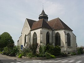 The church in La Chapelle-Saint-Luc | |
show Location of La Chapelle-Saint-Luc | |
 La Chapelle-Saint-Luc | |
| Coordinates: 48°18′45″N 4°02′43″E / 48.3125°N 4.0453°ECoordinates: 48°18′45″N 4°02′43″E / 48.3125°N 4.0453°E | |
| Country | France |
| Region | Grand Est |
| Department | Aube |
| Arrondissement | Troyes |
| Canton | Troyes-3 |
| Intercommunality | CA Troyes Champagne Métropole |
| Government | |
| • Mayor (2020–2026) | Olivier Girardin[1] |
| Area 1 | 10.48 km2 (4.05 sq mi) |
| Population (Jan. 2018)[2] | 11,913 |
| • Density | 1,100/km2 (2,900/sq mi) |
| Time zone | UTC+01:00 (CET) |
| • Summer (DST) | UTC+02:00 (CEST) |
| INSEE/Postal code | 10081 /10600 |
| Elevation | 98–164 m (322–538 ft) (avg. 100 m or 330 ft) |
| 1 French Land Register data, which excludes lakes, ponds, glaciers > 1 km2 (0.386 sq mi or 247 acres) and river estuaries. | |


La Chapelle-Saint-Luc (French pronunciation: [la ʃapɛl sɛ̃ lyk]) is a commune in the Aube department in north-central France, right next to Troyes.
Population[]
|
|
See also[]
References[]
- ^ "Répertoire national des élus: les maires". data.gouv.fr, Plateforme ouverte des données publiques françaises (in French). 2 December 2020.
- ^ "Populations légales 2018". INSEE. 28 December 2020.
External links[]
| Wikimedia Commons has media related to La Chapelle-Saint-Luc. |
| show Authority control |
|---|
This Aube geographical article is a stub. You can help Wikipedia by . |
Categories:
- Communes of Aube
- Aube geography stubs