Lagaip-Porgera District
Lagaip-Porgera District
Lagaip-Pogera District | |
|---|---|
 Location of Enga Province | |
 Lagaip-Porgera District Location within Papua New Guinea | |
| Coordinates: 5°27′48″S 143°08′42″E / 5.46333°S 143.14500°E | |
| Country | Papua New Guinea |
| Province | Enga Province |
| Capital | Lagaip-Porgera |
| Area | |
| • Total | 4,608 km2 (1,779 sq mi) |
| Population (2011 census) | |
| • Total | 158,873 |
| • Density | 34/km2 (89/sq mi) |
| Time zone | UTC+10 (AEST) |

Lagaip-Porgera District (also spelled local as Lagaip-Pogera District) is a district of the Enga Province of Papua New Guinea. Its principal towns are Laiagam and Porgera.
Administrative subdivisions[]
The district is divided into four Local Governments:
Demographics[]
The population of the district was 158,873 at the 2011 census.[1]
Climate[]
The average tempiture is 44.6°F . The warmest month is December, at 50°F, and the coolest month is February, at 35.6°F.[2] The average rainfall 124.96 inches per year.[3]
| ||||||||||||||||||||||||||||||||||||||||||||||||||||||||||||||||
Gallery[]

Gold specimen from Porgera Rural LLG collected in the 1980s.
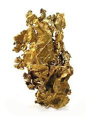
Gold specimen from the Pogera gold mine.
References[]
- ^ Districts of Papua New Guinea at statoids.com
- ^ "Browse datasets | NASA Earth Observations (NEO)". Browse datasets | NASA Earth Observations (NEO). 2020-06-11. Retrieved 2020-06-11.
- ^ "Rainfall (1 month - TRMM, 1998-2016) | NASA". Rainfall (1 month - TRMM, 1998-2016) | NASA. 2020-06-11. Retrieved 2020-06-11.
This Enga Province geography article is a stub. You can help Wikipedia by . |
Categories:
- Districts of Papua New Guinea
- Enga Province
- Highlands Region geography stubs