Districts of Papua New Guinea
 |
|---|
|
This page is a list of districts of Papua New Guinea.
Administrative divisions[]
On the highest level, Papua New Guinea is divided into 4 regions, which are Highlands, Islands, Momase, and Southern regions.
Below, Papua New Guinea has 22 province-level divisions: 20 integrated provinces, the autonomous province of North Solomons (Bougainville) and the National Capital District.
Each province has one or more districts, and each district has one or more local-level government (LLG) areas. For census purposes, the LLG areas are subdivided into wards and those into census units.[1]
Wards typically consist of a few hundred to a few thousand individuals, and are the lowest level of government administration under local-level governments (LLGs).

Districts and LLGs of Papua New Guinea
List of districts by region and province[]
Highlands Region[]
Chimbu Province[]
- Chuave District
- Gumine District
- Karimui-Nomane District
- Kerowagi District
- Kundiawa-Gembogl District
- Sina Sina-Yonggomugl District (Sinasina-Yonggomugl District)
Eastern Highlands Province[]

District map of Eastern Highlands Province
- Daulo District
- Goroka District
- Henganofi District
- Kainantu District
- Lufa District
- Obura-Wonenara District
- Okapa District
- Unggai-Benna District
Enga Province[]
Southern Highlands Province[]
- Ialibu-Pangia District
- Imbonggu District
- Kagua-Erave District
- Mendi-Munihu District
- Nipa-Kutubu District
Western Highlands Province[]
Hela Province[]
Jiwaka Province[]
Islands Region[]
East New Britain Province[]
Manus Province[]
New Ireland Province[]
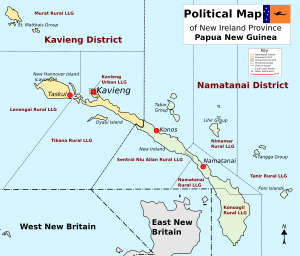
District map of New Ireland Province
West New Britain Province[]
Autonomous Region of Bougainville (Bougainville Region)[]

District map of North Solomons Province
Momase Region[]
East Sepik Province[]
- Ambunti-Dreikikier District
- Angoram District
- Maprik District
- Wewak District
- Wosera-Gawi District
- Yangoru-Saussia District
Madang Province[]
- Bogia District
- Madang District
- Middle Ramu District
- Rai Coast District
- Sumkar District
- Usino Bundi District
Morobe Province[]
- Finschhafen District
- Huon District
- Kabwum District
- Lae District
- Markham District
- Menyamya District
- Nawae District
- Tawae-Siassi District
- Bulolo_District
Sandaun (West Sepik) Province[]
Southern Region[]
Central Province[]
Gulf Province[]
Milne Bay Province[]
- Alotau District
- Esa'ala District
- Kiriwini-Goodenough District
- Samarai-Murua District
Oro (Northern) Province[]
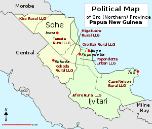
District map of Oro Province
Western (Fly) Province[]

District map of Western Province
- North Fly District
- Middle Fly District
- South Fly District
National Capital District[]
- National Capital District
See also[]
- Local-level governments of Papua New Guinea
- Provinces of Papua New Guinea
- Regions of Papua New Guinea
- List of cities and towns in Papua New Guinea
- List of cities and towns in Papua New Guinea by population
References[]
- ^ "Pacific Regional Statistics - Secretariat of the Pacific Community". www.spc.int. Retrieved 7 April 2018.
- "Census Figures by Wards - Highlands Region". www.nso.gov.pg. 2011 National Population and Housing Census: Ward Population Profile. Port Moresby: National Statistical Office, Papua New Guinea. 2014.
- "Census Figures by Wards - Islands Region". www.nso.gov.pg. 2011 National Population and Housing Census: Ward Population Profile. Port Moresby: National Statistical Office, Papua New Guinea. 2014.
- "Census Figures by Wards - Momase Region". www.nso.gov.pg. 2011 National Population and Housing Census: Ward Population Profile. Port Moresby: National Statistical Office, Papua New Guinea. 2014.
- "Census Figures by Wards - Southern Region". www.nso.gov.pg. 2011 National Population and Housing Census: Ward Population Profile. Port Moresby: National Statistical Office, Papua New Guinea. 2014.
- "Final Figures". www.nso.gov.pg. 2011 National Population and Housing Census: Ward Population Profile. Port Moresby: National Statistical Office, Papua New Guinea. 2014.
- United Nations in Papua New Guinea (2018). "Papua New Guinea - Postal codes and Coordinates". Humanitarian Data Exchange. 1.31.9.
External links[]
- National Statistical Office, Papua New Guinea (2011 National Population and Housing Census documents)
- Mapping Application with a lot of detail down to the LLG level
- LLG boundary maps by Province
- Local Level Government list – Inter Government relations department of PNG
- PNG Business Directory
- List of District Capitals
- Schedule of Polling for 2007 election[permanent dead link] – PNG Electoral Commission (document contains LLG details)
- List of LLGs by Province, with Presidents or Mayors
| show Articles on second-level administrative divisions of Oceanian countries |
|---|
Categories:
- Districts of Papua New Guinea
- Subdivisions of Papua New Guinea
- Lists of administrative divisions
- Administrative divisions in Oceania
- Second-level administrative divisions by country
- Papua New Guinea-related lists