Lai-Hka Township
Lai-Hka
လၢႆးၶႃႈ၊ ၸႄႈဝဵင်း လဲချားမြို့နယ် | |
|---|---|
Township | |
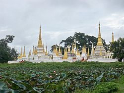 Pawrana Saeditaw Buddhist temple | |
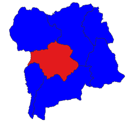 Location in Loilem district | |
 Lai-Hka Location in Burma | |
| Coordinates: 21°16′20″N 97°39′10″E / 21.27222°N 97.65278°ECoordinates: 21°16′20″N 97°39′10″E / 21.27222°N 97.65278°E | |
| Country | |
| State | Shan State |
| Shan | [Lai-Hka District] |
| Elevation | 971 m (3,186 ft) |
| Time zone | UTC+6.30 (MST) |

Lai-Hka Township is a township of Loilen District in the Shan State of Myanmar. The principal town is Lai-Hka.
History[]
Lai-Hka Township has had a turbulent and unstable history, with conflicts between the Shan State Army-South (SSA-S) and the Burmese Army. In the first half of 2009, there were at least four battles every month and the SPDC retaliated against villagers by confiscating property, extortion and forced relocation.
At the end of July 2009,[2] more than five hundred houses were burnt and 30 villages forcibly relocated in the township of Lai-Hka.[3]
References[]
- ^ GoogleEarth
- ^ "Scorched earth victims ordered to rebuild houses". Burma Digest. August 28, 2008. Archived from the original on September 1, 2009.
- ^ "Southern Shan State". Thailand Burma Border Consortium. Archived from the original on March 28, 2010. Retrieved February 28, 2010.
External links[]
 Media related to Lai-Hka Township at Wikimedia Commons


This Shan State location article is a stub. You can help Wikipedia by . |
Categories:
- Townships of Shan State
- Loilen District
- Shan State geography stubs