Lake Kronotskoye
| Lake Kronotskoye | |
|---|---|
| Lake Kronotskoe | |
 Lake Kronotskoye | |
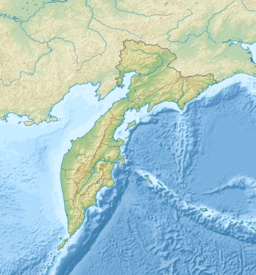
 Lake Kronotskoye Location in Kamchatka Krai, Russia | |
| Location | Kamchatka Krai, Russia |
| Coordinates | 54°47′N 160°15′E / 54.79°N 160.25°E |
| Primary inflows | Listvennichnaya, Unana, Uzon Rivers |
| Primary outflows | |
| Catchment area | 2,330 km2 (900 sq mi) |
| Surface area | 246 km2 (95 sq mi) |
| Average depth | 58 m (190 ft) |
| Max. depth | 136 m (446 ft) |
| Water volume | 14.2 km3 (3.4 cu mi) |
| Surface elevation | 372 m (1,220 ft) |
| References | [1][2] |

Lake Kronotskoye (Russian: Кроноцкое озеро) is a triangle-shaped lake located in Kamchatka Krai, Russia, 30 kilometres (19 mi) north of the Valley of Geysers and 40 kilometres (25 mi) away from the east coast of the Kamchatka Peninsula. It is named after the nearby volcano Kronotsky, part of the Eastern Range, whose name presumably derives from Itelmen krának, "high stone mountain." It was formed about 10,000 years ago when lava and pyroclastic flows from eruptions of the Kronotsky and Krasheninnikov volcanoes dammed the .[1]
Lake Kronotskoye covers an area of 246 square kilometres (95 sq mi) and has an average depth of 58 metres (190 ft) and a volume of 14.2 cubic kilometres (3.4 cu mi).[1] The lake drains an area of 2,330 square kilometres (900 sq mi),[1] with the Listvennichnaya, Unana and Uzon being the largest rivers to flow into it.[2] The lake drains into Kronotskaya River in its southeast corner, which flows 39 kilometres (24 mi) southeast into the Pacific Ocean.[3]
Lake Kronotskoye freezes over from late December to mid-May[3] to a depth of one metre. It is a dimictic lake, reaching isothermy in July and late November. The water is cold even in summer, not exceeding 16 °C (61 °F) even at its warmest in September. The pH at the surface decreases from 8.7 to 8.0 during the growing season.[1]
Massive rapids at the head of the Kronotskaya River prevent fish from entering or leaving the lake. Those that live in the lake are therefore of special scientific interest as model studies in microevolution processes. They comprise a population of landlocked sockeye or kokanee salmon and a group of char distinguished by its significant polymorphism and plasticity: researchers have identified between three and five different forms.[2] There are 11 islands in the eastern side of the lake which cover a total area of around 0.5 square kilometres (0.19 sq mi) and host a colony of about 600 pairs of slaty-backed gulls.[1] Lake Kronotskoye is also well known for its population of swans.[3]
The area surrounding the lake is uninhabited and protected as Kronotsky Nature Reserve, a component of the Volcanoes of Kamchatka World Heritage Site. The first Russians to reach the lake were the members of F.P. Ryabushinsky's Kamchatka expedition of 1908; the islands in the lake are named after them.[1]
References[]
- ^ Jump up to: a b c d e f g Izmaylova, A. V. "Кроноцкое озеро". Water of Russia (in Russian). Retrieved 21 May 2017.
- ^ Jump up to: a b c Pavlov, S. D.; Pivovarov, E. A.; Ostberg, C. O. (2012). "Dwarf char, a new form of chars (the genus Salvelinus) in Lake Kronotskoe". Doklady Biological Sciences. 442 (1): 20–23. doi:10.1134/S0012496612010048.
- ^ Jump up to: a b c "Kronotskoye Lake". Kronotsky Reserve. Retrieved 21 May 2017.
- Lakes of Kamchatka Krai
