Lake Livingston
| Lake Livingston | |
|---|---|
 | |
 Lake Livingston | |
| Location | Polk, San Jacinto, Trinity and Walker Counties, Texas |
| Coordinates | 30°44′N 95°09′W / 30.74°N 95.15°WCoordinates: 30°44′N 95°09′W / 30.74°N 95.15°W |
| Type | reservoir |
| Primary inflows | Trinity River |
| Primary outflows | Trinity River |
| Catchment area | 16,616 sq mi (43,040 km2)[1] |
| Basin countries | United States |
| Max. length | 31 mi (50 km) |
| Max. width | 9 mi (14 km) |
| Surface area | 336 km2 (130 sq mi) |
| Average depth | 23 ft (7.0 m) |
| Max. depth | 90 ft (27 m) |
| Water volume | 1,750,000 acre⋅ft (2.16 km3) |
| Shore length1 | over 450 mi (720 km) |
| Surface elevation | 131 ft (40 m) |
| Islands | Pine Island |
| Settlements | Trinity Onalaska Point Blank Riverside Sebastopol |
| References | [1] |
| 1 Shore length is not a well-defined measure. | |


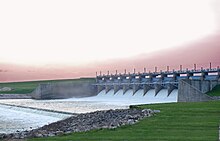
Lake Livingston is a reservoir located in the East Texas Piney Woods. Lake Livingston was built and is owned and operated by the Trinity River Authority (TRA) of Texas under contract with the City of Houston for water-supply purposes.[1] The lake is the second-largest lake located wholly within the state of Texas (only the Sam Rayburn Reservoir is larger). The Livingston Dam, constructed across the Trinity River about 7 miles (11 km) southwest of the city of Livingston is 2.5 miles (4 km) in length and has an average depth of 55 feet (17 m).[2]
Construction[]
The lake construction was paid for by the sale of revenue bonds that were to be redeemed with income derived from the sale of water. The dam construction began in 1966 and was completed in 1969, by Forrest and Cotton, Incorporated. The cost to build the earthen dam was US$83,996,957.
Use[]
Water stored in the lake is used to supply industrial, municipal, and agricultural needs in the lower Trinity River Basin and the Houston/Galveston metropolitan area. Its significance in the face of the extraordinary growth experienced by this region of the upper Texas Gulf Coast is tremendous. Many public and commercial recreation facilities, including full-service marinas, camping, and motel accommodations are located along the shoreline. The City of Houston owns two-thirds of the water rights of the lake, with the other third remaining under the control of the TRA.
The lake[]
The earthfill dam has a concrete spillway and was designed by Brown and Root, Incorporated (now KBR, Inc). The dam has a spillway crest elevation of 99 feet (30 m) above mean sea level. The average base width of the dam's earthen embankment is 310 feet (94 m) wide. The spillway is designed and constructed to pass flows of three times the maximum recorded flow of the river at this site.[2]
Lake Livingston has a surface area of 83,000 acres (360 km²) and impounds 1,750,000 acre-feet (2.16 km3) of water at its normal pool elevation of 131 feet (40 m) above mean sea level. The average depth of the lake is 23 feet (7 m) with a maximum depth of 90 feet (27 m). Lake Livingston has more than 450 miles (700 km) of shoreline extending into San Jacinto, Polk, Walker, and Trinity Counties.[2]
Flood control[]
Lake Livingston was built with no flood-control or flood-storage capabilities, and because of this, all water entering the lake, whether it be from rainfall or inflow, must exit the lake as increased intake occurs. Flow through the dam is controlled by 12 tainter gates in a concrete and steel spillway that has an average depth of 55 feet. Operations of the spillway mirrors river flow, so within a relatively short period of time, increase of river flow, discharge is increased, and vice versa.
Hurricane Rita[]
On September 23, 2005, rain and winds from Hurricane Rita caused waves up to 4 feet (1 m) in height to pound against the Lake Livingston dam. As a result, 11,000 feet (3.4 km) of large protective stones, or riprap, were stripped from the upstream face of the dam. To repair the damage, the TRA lowered the lake's pool level by 4 feet to 127 feet, preventing any further erosion of the exposed earthen embankment. The Federal Emergency Management Agency and the City of Houston footed the $9.6 million repair bill and awarded the repair contract to Archer Western Contractors. Over the course of the repair, movement of 72,215 tons of 32-inch rock in 3,183 truckloads and 15,808 tons of 8-inch (200 mm) bedding rock in 687 truckloads was required. The rock was mined from a quarry in Navarro County near Corsicana. Work was largely completed by April 28, 2006, but due to severe drought, the lake's regular pool level was not reached until November, 2006.
During the 2017 Hurricane Harvey, Lake Livingston reached a level of 133.52 feet [3] above mean sea level and released 110,600 ft3 of water per second.[4]
Entertainment references[]
Joe McKinney and Michael McCarty's "Lost Girl of the Lake" is a 2012 Bram Stoker Award Finalist from the Horror Writers Association, that takes place at Lake Livingston in the 1960s.[5] Lake Livingston was featured on the third episode of the first season of the television show, River Monsters, which airs on Animal Planet. The host, Jeremy Wade, was searching for alligator gar.[6]
References[]
- ^ Jump up to: a b c Lake Livingston from the Handbook of Texas Online. Retrieved 28 October 2014.
- ^ Jump up to: a b c Trinity River Authority of Texas - Lake Livingston Archived 2007-06-07 at the Wayback Machine. Retrieved 5 February 2007.
- ^ https://waterdata.usgs.gov/tx/nwis/uv/?site_no=08066190&PARAmeter_cd=62614
- ^ "Harvey flooding forces shelters to open in San Jacinto County". 27 August 2017. Retrieved 28 August 2017.
- ^ Grinning Skull Press, ISBN 0998691291, ISBN 978-0998691299
- ^ "Archived copy". Archived from the original on 2010-06-22. Retrieved 2010-05-10.CS1 maint: archived copy as title (link)
External links[]
- Trinity River Authority of Texas - Lake Livingston
- Trinity River Authority of Texas - Water supply
- Lake Livingston from the Handbook of Texas Online
- "Lake Livingston". Geographic Names Information System. United States Geological Survey. Retrieved Jan 17, 2021.
- TexasRiverData.com
- Lake Livingston Home page
- Experience Lake Livingston
| Authority control |
|
|---|
- Reservoirs in Texas
- Trinity River (Texas)
- Bodies of water of Polk County, Texas
- Bodies of water of San Jacinto County, Texas
- Bodies of water of Trinity County, Texas
- Bodies of water of Walker County, Texas
- Dams in Texas
- Protected areas of Polk County, Texas
- Protected areas of San Jacinto County, Texas
- Protected areas of Trinity County, Texas
- Protected areas of Walker County, Texas