Lancaster Township, Jefferson County, Indiana
Lancaster Township | |
|---|---|
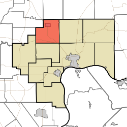 Location in Jefferson County | |
| Coordinates: 38°52′07″N 85°30′28″W / 38.86861°N 85.50778°WCoordinates: 38°52′07″N 85°30′28″W / 38.86861°N 85.50778°W | |
| Country | United States |
| State | Indiana |
| County | Jefferson |
| Government | |
| • Type | Indiana township |
| Area | |
| • Total | 32.23 sq mi (83.5 km2) |
| • Land | 32.18 sq mi (83.3 km2) |
| • Water | 0.05 sq mi (0.1 km2) 0.16% |
| Elevation | 794 ft (242 m) |
| Population (2010) | |
| • Total | 1,511 |
| • Density | 47/sq mi (18/km2) |
| GNIS feature ID | 0453539 |

Lancaster Township is one of ten townships in Jefferson County, Indiana, United States. As of the 2010 census, its population was 1,511 and it contained 635 housing units.[1]
History[]
Eleutherian College and the Lyman and Asenath Hoyt House are listed on the National Register of Historic Places.[2]
Geography[]
According to the 2010 census, the township has a total area of 32.23 square miles (83.5 km2), of which 32.18 square miles (83.3 km2) (or 99.84%) is land and 0.05 square miles (0.13 km2) (or 0.16%) is water.[1] The streams of Middle Fork Creek and Turkey Branch run through this township.
Cities and towns[]
Unincorporated towns[]
Extinct towns[]
- Five Points
Adjacent townships[]
- Bigger Township, Jennings County (north)
- Monroe Township (east)
- Madison Township (southeast)
- Smyrna Township (south)
- Graham Township (southwest)
- Lovett Township, Jennings County (west)
- Montgomery Township, Jennings County (west)
Cemeteries[]
The township contains five cemeteries: Bland, Clashman, College Hill, Nelson and Ogden.
Major highways[]
References[]
- "Lancaster Township, Jefferson County, Indiana". Geographic Names Information System. United States Geological Survey. Retrieved 2009-09-24.
- United States Census Bureau cartographic boundary files
- ^ a b "Population, Housing Units, Area, and Density: 2010 - County -- County Subdivision and Place -- 2010 Census Summary File 1". United States Census. Archived from the original on 2020-02-12. Retrieved 2013-05-10.
- ^ "National Register Information System". National Register of Historic Places. National Park Service. July 9, 2010.
External links[]
Municipalities and communities of Jefferson County, Indiana, United States | ||
|---|---|---|
| City | ||
| Towns | ||
| Townships | ||
| CDPs | ||
| Other unincorporated communities | ||
| Footnotes | ‡This populated place also has portions in an adjacent county or counties | |
| ||
Categories:
- Townships in Jefferson County, Indiana
- Townships in Indiana