Laredo–Colombia Solidarity International Bridge
Laredo-Colombia Solidarity International Bridge | |
|---|---|
 Laredo International Bridge 3 | |
| Coordinates | 27°41′59″N 99°44′44″W / 27.699716°N 99.745646°WCoordinates: 27°41′59″N 99°44′44″W / 27.699716°N 99.745646°W |
| Carries | Commercial Vehicles Non-commercial Vehicles |
| Crosses | Rio Grande |
| Locale | Laredo, Texas Colombia, Anáhuac Municipality, Nuevo León |
| Official name | Laredo-Colombia Solidarity International Bridge |
| Other name(s) | Laredo International Bridge 3 |
| Maintained by | City of Laredo Secretariat of Communications and Transportation |
| Characteristics | |
| Design | Box Girder Bridge |
| Total length | 1216 ft (371 m) |
| History | |
| Opened | 1992 |
| Statistics | |
| Daily traffic | Non-commercial: 294 Commercial: 924 |
| Toll | Non-Commercial Vehicles $1.75/axle (southbound)[1] 30 pesos (northbound)[2] Commercial Vehicles $4.75/axle (southbound)[1] 60 pesos (northbound)[2] |
| Location | |
 | |

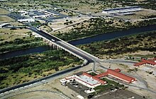
Laredo–Colombia Solidarity International Bridge is one of four vehicular international bridges located on the U.S.-Mexico border in the city of Laredo, Texas; it connects Laredo over the Rio Grande (Rio Bravo) with Colombia in Anáhuac, Nuevo León. It is owned and operated by the City of Laredo and the Secretaría de Comunicaciones y Transportes (Mexico's Federal Ministry of Communications and Transportation).
History[]
The Laredo–Colombia Solidarity International Bridge was named in honor of the Mexican planned community of Colombia, Nuevo León. The community and the international bridge were built because the Mexican state of Nuevo León wanted an international port to compete with the bordering states of Coahuila and Tamaulipas in the International Trade market. This is the only border crossing between Nuevo León and Texas.
Description[]
The Laredo–Colombia Solidarity International Bridge is an eight-lane bridge with two walkways for pedestrians. The bridge is 1,216 feet (371 m) long. The international bridge is for all traffic, including pedestrians. The bridge is also known as Laredo International Bridge 3, Colombia Bridge, Puente Solidaridad, Puente Colombia and Puente Internacional Solidaridad Colombia.[3]
On the United States side, the bridge connects to Texas State Highway 255, a road that bypasses downtown Laredo and connects to Interstate 35. On the Mexico side, the bridge connects to Nuevo Leon State Highway 1 Spur which in turn connects it to Highway 1 proper.
Location[]
This bridge is located at the western terminus of State Highway 255, near its intersection with FM 1472, in Laredo, Texas and the northern terminus of Nuevo León State Highway Spur 1 in Colombia, Anáhuac Municipality.
Border crossing[]
The Laredo Columbia Solidarity Port of Entry was built in 1991 in an effort to relieve traffic from the congested downtown Laredo bridges.[4]
Operational hours[]
Commercial Vehicles
- Sunday: 10:00 AM–2:00 PM
- Weekdays: 8:00 AM–10:30 PM
- Saturday: 9:00 AM–4:00 PM
Non-commercial Vehicles
- All Days: 8:00 AM–12:00 AM[5]
All times Central Time Zone
References[]
- ^ Jump up to: a b http://www.cityoflaredo.com/bridgesys/Fees/BridgeFees2.pdf[bare URL]
- ^ Jump up to: a b http://pot.capufe.mx/gobmx/Transparencia/Doc/TransparenciaF/Tarifas/Vigentes/Tarifas-VIGENTES-2020.pdf[bare URL]
- ^ TxDOT Transportation Planning; Border Crossings
- ^ "Border Crossing Travel Time Study, FINAL Study Report, Volume II: TxDOT Laredo District". RJ RIVERA Associates, Inc. for Texas Department of Transportation, Transportation Planning and Programming Division. Archived from the original on 26 December 2008. Retrieved 22 July 2012.
- ^ "Archived copy". Archived from the original on 2012-10-30. Retrieved 2012-10-30.CS1 maint: archived copy as title (link)
External links[]
- Laredo-Colombia Solidarity International Bridge Webcam (American Side)
- Laredo-Colombia Solidarity International Bridge Webcam (Mexican Side)
- Aerial View of Laredo-Colombia Solidarity International Bridge
- Statistical Data

| Authority control |
|
|---|
- International bridges in Laredo, Texas
- International bridges in Nuevo León
- Nuevo León
- Toll bridges in Texas
- Bridges completed in 1992
- Road bridges in Texas
- Toll bridges in Mexico
- Box girder bridges in the United States
- Box girder bridges