Lassa, Lebanon
Lassa
لاسا | |
|---|---|
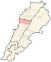
 Lassa Location in Lebanon | |
| Coordinates: 34°4′34″N 35°51′36″E / 34.07611°N 35.86000°ECoordinates: 34°4′34″N 35°51′36″E / 34.07611°N 35.86000°E | |
| Country | Lebanon |
| Governorate | Keserwan-Jbeil |
| District | Byblos |
| Area | |
| • Total | 739 ha (1,826 acres) |
| Elevation | 1,130 m (3,710 ft) |

Lassa (Arabic: لاسا) is a municipality in the Byblos District of Keserwan-Jbeil Governorate, Lebanon. It is 90 kilometers north of Beirut. Lassa has an average elevation of 1,130 meters above sea level and a total land area of 739 hectares. The village contains one public school, which enrolled 15 students in 2008.[1] Its inhabitants are predominantly Shia Muslims.[2]
Lassa was the seat of the Shia Muslim house of Hamadeh, which exercised control over large swaths of Mount Lebanon in the 17th and 18th centuries, including the districts of Jubbay al-Mnaytra, Bilad Jubayl (Byblos), Bilad al-Batrun and Jubbat Bsharray. Lassa was burnt by the Ottomans many times in reprisal for the Hamadeh lords' failure to remit tax incomes. In the late 18th century, the Hamadeh and their clans (al-'asha'ir al-hamadiyah) were driven out of Lassa and surrounding villages, to the eastern slopes of Mount Lebanon, the Hirmil region and the area of Ba'lbak. Some of the Shia Muslim families remained. The biggest family in Lassa is Al Mokdad. Al Eitawi family comes after it.
References[]
- ^ "Lassa". Localiban. Localiban. 2008-01-17. Retrieved 2016-02-12.
- ^ and a persecuted maronite minorityCammett, Melani; Issar, Sukriti (July 2010). "Bricks and Mortar Clientalism: Sectarianism and the Logics of Welfare Allocation in Lebanon". World Politics. 62 (3): 381–421. doi:10.1353/wp.0.0056 (inactive 31 October 2021). PMC 4029429. PMID 24860198.CS1 maint: DOI inactive as of October 2021 (link)
Capital: Byblos | ||
| Towns and villages |
|  |
| Landmarks | ||
This Lebanon location article is a stub. You can help Wikipedia by . |
- Populated places in Byblos District
- Shia Muslim communities in Lebanon
- Populated places in Lebanon
- Lebanon geography stubs