Laurel, Nebraska
Laurel, Nebraska | |
|---|---|
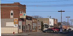 Downtown Laurel: 2nd Street east of Elm Street | |
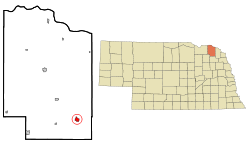 Location of Laurel, Nebraska | |
| Coordinates: 42°25′41″N 97°5′35″W / 42.42806°N 97.09306°WCoordinates: 42°25′41″N 97°5′35″W / 42.42806°N 97.09306°W | |
| Country | United States |
| State | Nebraska |
| County | Cedar |
| Government | |
| • Mayor | Keith Knudsen[1] |
| Area | |
| • Total | 1.18 sq mi (3.06 km2) |
| • Land | 1.18 sq mi (3.06 km2) |
| • Water | 0.00 sq mi (0.00 km2) |
| Elevation | 1,476 ft (450 m) |
| Population | |
| • Total | 964 |
| • Estimate (2019)[4] | 916 |
| • Density | 776.27/sq mi (299.83/km2) |
| Time zone | UTC-6 (Central (CST)) |
| • Summer (DST) | UTC-5 (CDT) |
| ZIP code | 68745 |
| Area code(s) | 402 |
| FIPS code | 31-26350[5] |
| GNIS feature ID | 0830637[6] |
| Website | Official City website |

Laurel is a city in Cedar County, Nebraska, United States. The population was 964 at the 2010 census.[7]
History[]
Laurel was founded circa 1893.[8] It was originally named Claremont Junction. The present name is after Laura Martin, the daughter of one of the founders.[9]
Geography[]
Laurel is located at 42°25′41″N 97°5′35″W / 42.42806°N 97.09306°W (42.427966, -97.093053).[10]
According to the United States Census Bureau, the city has a total area of 0.98 square miles (2.54 km2), all land.[11]
U.S. Route 20 and Nebraska Highway 15 serve the community.
Laurel is located in the Laurel-Concord-Coleridge School District.[12]
Demographics[]
| Historical population | |||
|---|---|---|---|
| Census | Pop. | %± | |
| 1900 | 514 | — | |
| 1910 | 514 | 0.0% | |
| 1920 | 830 | 61.5% | |
| 1930 | 864 | 4.1% | |
| 1940 | 861 | −0.3% | |
| 1950 | 944 | 9.6% | |
| 1960 | 922 | −2.3% | |
| 1970 | 1,009 | 9.4% | |
| 1980 | 1,031 | 2.2% | |
| 1990 | 981 | −4.8% | |
| 2000 | 986 | 0.5% | |
| 2010 | 964 | −2.2% | |
| 2019 (est.) | 916 | [4] | −5.0% |
| U.S. Decennial Census[13] | |||
2010 census[]
At the 2010 census there were 964 people in 415 households, including 263 families, in the city. The population density was 983.7 inhabitants per square mile (379.8/km2). There were 474 housing units at an average density of 483.7 per square mile (186.8/km2). The racial makeup of the city was 96.8% White, 0.2% African American, 0.2% Native American, 0.3% Asian, 1.2% from other races, and 1.2% from two or more races. Hispanic or Latino of any race were 2.4%.[3]
Of the 415 households 26.3% had children under the age of 18 living with them, 56.4% were married couples living together, 5.3% had a female householder with no husband present, 1.7% had a male householder with no wife present, and 36.6% were non-families. 33.5% of households were one person and 16.4% were one person aged 65 or older. The average household size was 2.26 and the average family size was 2.90.
The median age was 44.7 years. 22.6% of residents were under the age of 18; 6.4% were between the ages of 18 and 24; 21.3% were from 25 to 44; 25% were from 45 to 64; and 24.7% were 65 or older. The gender makeup of the city was 48.0% male and 52.0% female.
2000 census[]
At the 2000 census there were 986 people in 414 households, including 264 families, in the city. The population density was 1,072.5 people per square mile (413.8/km2). There were 466 housing units at an average density of 506.9 per square mile (195.6/km2). The racial makeup of the city was 99.49% White, 0.20% Native American, 0.10% Pacific Islander, 0.10% from other races, and 0.10% from two or more races. Hispanic or Latino of any race were 0.30%.[5]
Of the 414 households 26.3% had children under the age of 18 living with them, 56.3% were married couples living together, 6.3% had a female householder with no husband present, and 36.0% were non-families. 32.9% of households were one person and 22.9% were one person aged 65 or older. The average household size was 2.28 and the average family size was 2.91.
The age distribution was 23.3% under the age of 18, 6.3% from 18 to 24, 20.4% from 25 to 44, 19.8% from 45 to 64, and 30.2% 65 or older. The median age was 45 years. For every 100 females, there were 85.0 males. For every 100 females age 18 and over, there were 79.1 males.
The median household income was $29,722, and the median family income was $35,662. Males had a median income of $26,731 versus $20,833 for females. The per capita income for the city was $16,500. About 6.0% of families and 8.4% of the population were below the poverty line, including 10.0% of those under age 18 and 7.2% of those age 65 or over.
Notable people[]
- James Coburn, actor
- Mark Calcavecchia, professional golfer
External links[]
References[]
- ^ "Contact Us / Government".
- ^ "2019 U.S. Gazetteer Files". United States Census Bureau. Retrieved July 26, 2020.
- ^ a b "U.S. Census website". United States Census Bureau. Retrieved 2012-06-24.
- ^ a b "Population and Housing Unit Estimates". United States Census Bureau. May 24, 2020. Retrieved May 27, 2020.
- ^ a b "U.S. Census website". United States Census Bureau. Retrieved 2008-01-31.
- ^ "US Board on Geographic Names". United States Geological Survey. 2007-10-25. Retrieved 2008-01-31.
- ^ "Many Area Neb. Counties Lose Population".
- ^ "Laurel, Cedar County". Center for Advanced Land Management Information Technologies. University of Nebraska. Retrieved 1 August 2014.
- ^ Fitzpatrick, Lillian L. (1960). Nebraska Place-Names. University of Nebraska Press. p. 34. ISBN 0803250606.
- ^ "US Gazetteer files: 2010, 2000, and 1990". United States Census Bureau. 2011-02-12. Retrieved 2011-04-23.
- ^ "US Gazetteer files 2010". United States Census Bureau. Archived from the original on 2012-01-25. Retrieved 2012-06-24.
- ^ http://www.lccschool.org/
- ^ "Census of Population and Housing". Census.gov. Retrieved June 4, 2015.
Municipalities and communities of Cedar County, Nebraska, United States | ||
|---|---|---|
| Cities | ||
| Villages | ||
| CDPs | ||
| Unincorporated communities | ||
| ||
- Cities in Cedar County, Nebraska
- Cities in Nebraska
- Populated places established in 1892
- 1892 establishments in Nebraska