Laurel Highlands Hiking Trail
| Laurel Highlands Hiking Trail | |
|---|---|
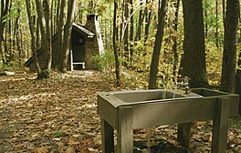 A backpacking shelter along the Laurel Highlands Hiking Trail | |
| Length | 70 mi (110 km) |
| Location | Southwestern Pennsylvania, US |
| Trailheads | Ohiopyle State Park Pennsylvania Route 56 |
| Use | Hiking |
| Elevation | |
| Highest point | High |
| Hiking details | |
| Trail difficulty | Moderate to strenuous |
| Season | Year-round |
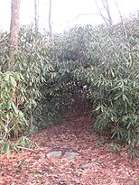
The Laurel Highlands Hiking Trail is a 70-mile (110 km) hiking trail in southwestern Pennsylvania, which largely follows the Laurel Hill geologic formation. Some of the trail is within the boundaries of various tracts of Laurel Ridge State Park. The trail begins at Ohiopyle State Park and travels generally to the northeast, and ends at Conemaugh Gorge near Johnstown. The trail goes through state forests, state parks, state game lands, and some privately owned lands. Laurel Highlands Hiking Trail is open year-round and is marked with yellow blazes, with large wooden signs at every major highway crossing. Connector trails are marked with blue blazes; those trails connect the main trail with parking and shelter areas. Six parking lots at the highway crossings provide starting points; some have access to drinking water.[1] Construction of the trail began in 1970.
Shelter areas[]
There are eight overnight shelter areas on the Laurel Highlands Hiking Trail, all of which are within the boundaries of various tracts of Laurel Ridge State Park. These shelter areas are located about every 6 miles (9.7 km) to 10 miles (16 km) along the trail. The shelter areas each have five Adirondack style shelters. There are two outhouses at the rest stops and a water supply. There is room for up to 30 tents at each stop. Firewood is provided. Hikers using the shelters are required to make reservations for use of the shelters with staff at Laurel Ridge State Park before setting out on their hike. A fee is charged to users of the shelters.[1]
Course[]

The Laurel Highlands Hiking Trail mileage starts from the southern trailhead in Ohiopyle State Park. The trail runs east through the park and parallel to the Youghiogheny River within Stewart Township in Fayette County for the first 6 miles (9.7 km).[2] Just past mile 6 the trail comes to the first overnight shelter area (with non-potable water), where it turns northeast.[3] At 7 miles (11 km) the trail leaves the park and Fayette County, and enters Lower Turkeyfoot Township in Somerset County and Pennsylvania State Game Lands No. 111.[4] Just before 15 miles (24 km), the trail enters Laurel Ridge State Park for the first time, where it continues northeast. Just past 17 miles (27 km) the trail turns north, and crosses back into Fayette County (now Springfield Township), where the second overnight shelter with potable water is found.[2][3]
The trail runs generally northeast and passes the Laurel Ridge State Park office near 19 miles (31 km), enters Saltlick Township, Fayette County at about 23 miles (37 km), then leaves the park and enters Forbes State Forest just before 24 miles (39 km).[2] Shortly after this the trail returns to Somerset County (Middlecreek Township) and passes the third overnight shelter area with potable water. Between 25 miles (40 km) and 26 miles (42 km) the trail follows the border between Laurel Ridge State Park and Forber State Forest, then leaves public land for private property. It crosses the borough of Seven Springs and runs just west of Seven Springs Mountain Resort and Laurel Hill State Park.[4] Just before 29 miles (47 km) the trail crosses into Donegal Township in Westmoreland County, and shortly after enters the state forest and then Laurel Ridge State Park again.[5] At about 31.5 miles (50.7 km), the trail crosses back into Somerset County (Jefferson Township), and just past 32 miles (51 km) passes the fourth overnight shelter area, with potable water. It runs west of Kooser State Park and continues for several miles just east of the county line, crossing the Pennsylvania Turnpike (Interstate 70/76) before 37 miles (60 km). The pedestrian bridge over the turnpike was closed in December 2009, when it was deemed to be in such poor condition that it was too unstable to use.[6] The bridge was reopened in January 2012.[7][8] This stretch of trail runs through the state forest and three separate small tracts of Laurel Ridge State Park.[3][4]
At 38 miles (61 km), the trail crosses from the state forest back into Laurel Ridge State Park and Lincoln Township in Somerset County, then crosses briefly into Cook Township in Westmoreland County.[4][5][9] It crosses back into Somerset County and comes to the fifth overnight shelter with potable water, then reaches Laurel Summit State Park at 39 miles (63 km). Continuing through the state forest, the trail crosses into Jenner Township in Somerset County just past 41 miles (66 km), and back into Laurel Ridge State Park at 43.5 miles (70.0 km), passing east of Linn Run and Laurel Mountain state parks along this section. The trail crosses U.S. Route 30 just before 46 miles (74 km) and reaches the sixth overnight shelter with potable water just after. It continues through the state park to 50 miles (80 km), then enters State Game Lands No. 42, then crosses into Ligonier Township in Westmoreland County.[5] The trail leaves the Game Lands at 53 miles (85 km), travels through Laurel Ridge State Park for 1 mile (1.6 km), crosses back into the Game Lands, and into Jenner Township in Somerset County again. Just before 55 miles (89 km) the trail again passes through the state park where it enters Conemaugh Township in Somerset County, then enters private land at about 55.5 miles (89.3 km). The trail enters another tract of the state park before 57 miles (92 km), where it crosses Pennsylvania Route 271 and the seventh overnight shelter with potable water is located. Just after this the trail enters State Game Lands No. 42, then at 57.5 miles (92.5 km) crosses into Upper Yoder Township in Cambria County.[9][10]
The trail continues through State Game Lands No. 42 and crosses back into Westmoreland County (Fairfield Township) just before 59 miles (95 km). At about 60 miles (97 km) the trail enters St. Clair Township in Westmoreland County, and between here and 62 miles (100 km) it crosses twice into Lower Yoder Township in Cambria County. It finally leaves the State Game Lands and enters Laurel Ridge State park for the final time before 63 miles (101 km), crossing back into Cambria County (Lower Yoder Township) shortly after that. The eighth and final overnight shelter with potable water is past 64 miles (103 km) and the trail continues northeast until just before 67 miles (108 km), where it turns north and then crosses into Westmoreland County (St. Clair Township). The trail now runs parallel to the Conemaugh River with several vistas of the river valley, and finally ends just before70 miles (110 km) at a parking area off of Pennsylvania Route 56.[9][5][10]
References[]
- ^ a b "Laurel Ridge State Park". Pennsylvania Department of Conservation and Natural Resources. Retrieved December 2, 2006.
- ^ a b c 2007 General Highway Map Fayette County Pennsylvania (PDF) (Map). 1:65,000. Pennsylvania Department of Transportation, Bureau of Planning and Research, Geographic Information Division. Retrieved July 27, 2006.[permanent dead link] Note: shows Laurel Ridge State Park
- ^ a b c Laurel Ridge State Park (south park map) (PDF) (Map). 1 inch = 1.3 miles. Pennsylvania Department of Transportation, Bureau of Planning and Research, Geographic Information Division. Retrieved November 12, 2007. Note: shows Laurel Highlands Hiking Trail
- ^ a b c d 2007 General Highway Map Somerset County Pennsylvania (PDF) (Map). 1:65,000. Pennsylvania Department of Transportation, Bureau of Planning and Research, Geographic Information Division. Retrieved July 27, 2006.[permanent dead link] Note: shows small tracts of Laurel Ridge State Park not shown on the DCNR trail map
- ^ a b c d 2007 General Highway Map Westmoreland County Pennsylvania (PDF) (Map). 1:65,000. Pennsylvania Department of Transportation, Bureau of Planning and Research, Geographic Information Division. Retrieved July 27, 2006.[permanent dead link] Note: shows Laurel Ridge State Park
- ^ Schmitz, Jon (December 26, 2009). "Closed bridge splits hiking trail: Span was only way for outdoors lovers to cross turnpike". Pittsburgh Post-Gazette. Retrieved December 26, 2009.
- ^ Nass, Shannon (February 5, 2012). "Bridge is back on Laurel Highlands trail". Pittsburgh Post-Gazette. Retrieved June 3, 2013.
- ^ Brady, Terry. "DCNR Dedicates New Laurel Highlands Hiking Trail Bridge" (PDF). DCNR. Retrieved June 3, 2013.
- ^ a b c Laurel Ridge State Park (north park map) (PDF) (Map). 1 inch = 1.3 miles. Pennsylvania Department of Transportation, Bureau of Planning and Research, Geographic Information Division. Retrieved November 12, 2007. Note: shows Laurel Highlands Hiking Trail
- ^ a b 2007 General Highway Map Cambria County Pennsylvania (PDF) (Map). 1:65,000. Pennsylvania Department of Transportation, Bureau of Planning and Research, Geographic Information Division. Retrieved July 27, 2006.[permanent dead link] Note: shows Laurel Ridge State Park
| ||
- Hiking trails in Pennsylvania