Lauwers
This article does not cite any sources. (December 2009) |
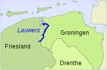
The Lauwers (Dutch pronunciation: [ˈlʌuʋərs]) is a river in the Netherlands. It forms part of the border between the provinces of Friesland and Groningen. From the 730s to Widukind's defeat in 785, it was part of the border of the Frankish Empire.
The former Lauwerszee and the present-day Lauwersmeer are both named after the river, which as a small stream has its source southeast of the village of Surhuisterveen. Near Gerkesklooster/Stroobos, it crosses the /.
The Lauwers achieves the width of a true river at the place that it gains its tributary, the , near the . Further along its course, the Lauwers splits into two branches, the Frisian and the , in Groningen province.
The Lauwers meets the sea at the Wadden Sea, emptying into a channel between the islands of Schiermonnikoog and Rottumerplaat/Rottumeroog, which can be viewed as the continuation of the river.

Lauwers River

Coordinates: 53°15′24″N 6°14′0″E / 53.25667°N 6.23333°E
- Rivers of Groningen (province)
- Rivers of Friesland
- Rivers of the Netherlands
- Coastal basins of the Netherlands
- Europe river stubs
- Netherlands geography stubs