Lawndale, Logan County, Illinois
Lawndale, Illinois | |
|---|---|
Unincorporated community | |
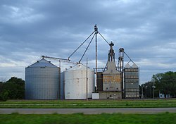 The Lawndale grain elevator (with old "Faultless Feed" sign) is the most visible building. | |
 Lawndale | |
| Coordinates: 40°13′05″N 89°16′57″W / 40.21806°N 89.28250°WCoordinates: 40°13′05″N 89°16′57″W / 40.21806°N 89.28250°W | |
| Country | United States |
| State | Illinois |
| County | Logan |
| Township | East Lincoln |
| Elevation | 600 ft (200 m) |
| Time zone | UTC-6 (Central (CST)) |
| • Summer (DST) | UTC-5 (CDT) |
| ZIP code | 61751 |
| Area code(s) | 217 |
| GNIS feature ID | 411862[1] |


Lawndale is a community in Logan County, Illinois, United States which lies northeast of Springfield. The town lies on Interstate 55, part of the old Route 66, between Atlanta and Lincoln. The town lies just south of Kickapoo Creek. The town has one tavern, a grain elevator, and a converted mobile home as its post office.
Lawndale was laid out and platted in 1854, soon after the Alton & Sangamon (now Chicago & Alton) railroad was extended to that point.[2] A post office called Lawndale has been in operation since 1855.[3]
References[]
- ^ U.S. Geological Survey Geographic Names Information System: Lawndale, Logan County, Illinois
- ^ Stringer, Lawrence Beaumont (1911). History of Logan County, Illinois: A Record of Its Settlement, Organization, Progress, and Achievement. Unigraphic. p. 628.
- ^ "Logan County". Jim Forte Postal History. Retrieved 16 January 2016.
| show Municipalities and communities of Logan County, Illinois, United States |
|---|
| show Authority control |
|---|
This Logan County, Illinois location article is a stub. You can help Wikipedia by . |
Categories:
- Populated places in Logan County, Illinois
- Central Illinois geography stubs