Lawrence J. Timmerman Airport
Coordinates: 43°06′37″N 088°02′04″W / 43.11028°N 88.03444°W

Lawrence J. Timmerman Airport | |||||||||||||||||||||||
|---|---|---|---|---|---|---|---|---|---|---|---|---|---|---|---|---|---|---|---|---|---|---|---|
 | |||||||||||||||||||||||
| Summary | |||||||||||||||||||||||
| Airport type | Public | ||||||||||||||||||||||
| Owner | Milwaukee County | ||||||||||||||||||||||
| Serves | Milwaukee, Wisconsin | ||||||||||||||||||||||
| Elevation AMSL | 745 ft / 227 m | ||||||||||||||||||||||
| Website | timmermanairport | ||||||||||||||||||||||
| Maps | |||||||||||||||||||||||
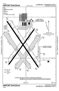 FAA airport diagram | |||||||||||||||||||||||
 MWC Location of airport in Wisconsin, United States | |||||||||||||||||||||||
| Runways | |||||||||||||||||||||||
| |||||||||||||||||||||||
| Statistics | |||||||||||||||||||||||
| |||||||||||||||||||||||

Lawrence J. Timmerman Airport (IATA: MWC, ICAO: KMWC, FAA LID: MWC), known locally as Timmerman Field, is an airport in Milwaukee, Wisconsin, United States, owned by Milwaukee County. Located 5 miles (8 km) northwest of the city center, it is used mainly for general or private aviation.[1] It is included in the Federal Aviation Administration (FAA) National Plan of Integrated Airport Systems for 2021–2025, in which it is categorized as a regional reliever airport facility.[2]
History[]
The airport was built in 1929 and dedicated on July 6, 1930,[3] one of 25 such projects in U.S. cities by the newly incorporated airplane manufacturer Curtiss-Wright.[4] The airport was originally known as Curtiss-Wright Field, hence the letters "WC" in its airport codes. In 1945, Curtiss-Wright sold it to Fliteways, Inc., the airport's property manager since 1936.[5] Milwaukee County purchased the airport from Fliteways in July 1947, when it was 131 acres (53 ha) in size.[6][7][8] It was host to the Experimental Aircraft Association's earliest Fly-In Conventions from 1953 to 1958. The airport was renamed in July 1959 for Lawrence J. Timmerman (1878–1959), chairman of the Milwaukee County Board of Supervisors from 1936 to 1959.[9][10]
Current users[]
Lawrence J. Timmerman Airport currently serves various general aviation groups. The current fixed-base operator is Spring City Aviation. The airport is home to the Milwaukee chapter of Youth and Aviation, as well as two Civil Air Patrol squadrons: the Timmerman Composite Squadron and the Milwaukee Senior Support Squadron 10. The airport also serves many private and public users.
Facilities and aircraft[]
Lawrence J. Timmerman Airport covers an area of 420 acres (170 ha) and contains two asphalt paved runways: 15L/33R measuring 4,103 x 75 ft (1,251 x 23 m) and 4L/22R measuring 3,201 x 75 ft (976 x 23 m). It also has two turf runways: 15R/33L measuring 3,231 x 270 ft (985 x 82 m) and 4R/22L measuring 2,839 x 270 ft (865 x 82 m).[1]
For the 12-month period ending August 31, 2020, the airport had 36,717 aircraft operations, an average of 101 per day: 97% general aviation, 2% military and just less than 1% air taxi. In November 2021, there were 88 aircraft based at this airport: 78 single-engine, 7 multi-engine, 2 jet and 1 helicopter.[1]
References[]
- ^ a b c d FAA Airport Form 5010 for MWC PDF, effective November 4, 2021.
- ^ "NPIAS Report 2019-2023 Appendix A" (PDF). Federal Aviation Administration. October 3, 2018. Retrieved October 12, 2018.
- ^ "Flying Stunts to Open Field", The Milwaukee Journal, July 3, 1930, p. 3.
- ^ "Born of Foresight, Timmerman Field Grows Big, Fast", The Milwaukee Journal, October 10, 1968, Accent section, p. 1.
- ^ "Curtiss-Wright Airport Is Sold", The Milwaukee Journal, December 11, 1945, sec. 2, p. 1.
- ^ "County Votes Purchase of Curtiss-Wright Field", The Milwaukee Journal, April 24, 1946, sec. 2, p. 1.
- ^ "Curtiss-Wright Favored as Minor County Field", The Milwaukee Journal, April 12, 1946, p. 20.
- ^ "County Eyes Curtiss Airport", The Milwaukee Journal, June 5, 1947, Final section, p. 1.
- ^ "Timmerman Fete Today at Airport", The Milwaukee Sentinel, July 21, 1959, sec. 2, p. 1.
- ^ "Timmerman Death Ends Civic Career", The Milwaukee Sentinel, October 6, 1959, sec. 2, p. 1.
External links[]
- Wisconsin Airport Directory: "Lawrence J. Timmerman Airport" (PDF).
- FAA Airport Diagram (PDF), effective December 30, 2021
- Resources for this airport:
- FAA airport information for MWC
- AirNav airport information for KMWC
- ASN accident history for MWC
- FlightAware airport information and live flight tracker
- NOAA/NWS weather observations: current, past three days
- SkyVector aeronautical chart, Terminal Procedures
Civil aviation in Wisconsin | ||
|---|---|---|
| Primary airports | ||
| Airlines | ||
| Museums | ||
| Aviation related | ||
| People |
| |
|  | |
| ||
- Airports in Wisconsin
- Buildings and structures in Milwaukee
- Transportation in Milwaukee
- Airports established in 1929