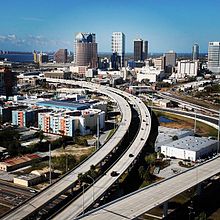
Lee Roy Selmon Expressway
This article needs to be updated. (September 2010) |
 | ||||
|---|---|---|---|---|
| Lee Roy Selmon Expressway Lee Roy Selmon Tollway | ||||
Lee Roy Selmon Expressway highlighted in red | ||||
| Route information | ||||
| Maintained by Tampa-Hillsborough Expressway Authority | ||||
| Length | 14.132 mi[1] (22.743 km) | |||
| Existed | 1976–present | |||
| Major junctions | ||||
| West end | ||||
| East end | ||||
| Location | ||||
| Counties | Hillsborough | |||
| Highway system | ||||
| ||||

The Lee Roy Selmon Expressway, originally known as the Southern Crosstown Expressway is a 14.168-mile (22.801 km) all-electronic, limited access toll road in Hillsborough County, Florida, It connects the South Tampa neighborhood near MacDill Air Force Base with Downtown Tampa and the bedroom community of Brandon. The expressway was built in stages, opening between 1976 and 1987. An approximately 1.9 mile extension to the thoroughfare's western terminus opened to traffic on Monday, April 19, 2021.[2]
The expressway was supposed to be part of a multi-expressway system that failed in the 1970s due to heavy local opposition and financial burdens. The original designation for the expressway was State Road 449, but was switched to State Road 618, which remained a hidden designation until the early 2000s, when it began appearing on maps and in atlases.
The expressway features an elevated bridge, the world's first reversible, all-electronic, elevated express lane project, opened in 2006, with the hidden designation of State Road 618A.[1] The entire expressway ended cash collection on September 17, 2010, going all-electronic for both the express lanes and the main expressway.
The expressway was renamed Lee Roy Selmon Crosstown Expressway in 1999, in honor of former Tampa Bay Buccaneers hall-of-fame football player Lee Roy Selmon. The "Crosstown" portion of the name was dropped in 2008, although it is still referred to as the "Crosstown" by the majority of the population. Most traffic reports and locals refer to it as the Crosstown.
Route description[]
This section needs expansion. You can help by . (January 2010) |
The tollway begins at an interchange with U.S. Route 92 (Gandy Boulevard) and Dale Mabry Highway north of MacDill Air Force Base. It makes its way northeast along a lightly used CSX rail corridor for the first four miles before heading east towards downtown Tampa. From Florida Ave, the highway winds through the Channelside District and the southern fringe of Ybor City before continuing due eastward towards 78th St. There is a connection to I-4 just east of 22nd St that allows commuters to easily move between various points throughout Hillsborough County and beyond. Just west of 78th St, the expressway crosses over Palm River (the southernmost portion of the Tampa Bypass Canal) and makes a southeastward curve towards US 301. From there, the highway crosses over US 301 and Falkenburg Road before ending at a trumpet interchange with I-75 in Brandon.[3]
Express lanes[]
The reversible express lanes (REL), also known as State Road 618A, begin at Meridian Avenue in downtown Tampa, following the main expressway's path from above in the center median for most of its journey. Almost the entire route is elevated, with the exception of at-grade segments between 26th Street and 39th Street, as well as between 78th Street and I-75. An at-grade provision was made between 26th Street and 39th Street to accommodate the newly opened Interstate 4/Selmon Expressway Connector. This at-grade portion is equipped with an eastbound (only) slip-ramp to allow commuters from South Tampa to utilize the REL. A toll gantry is located just east of 78th Street and is the only toll gantry along the entire REL. Between 78th Street and US 301, slip-ramps exist for both directions (exiting and entering the REL). The REL crosses over I-75 and ends at Town Center Boulevard in Brandon (near Westfield Brandon). From there, the highway disperses onto the Brandon Parkway, which connects to Providence Road and other redesigned thoroughfares to allow seamless connection to points within Brandon and surrounding areas.[4]
Operating hours[]
On weekdays, the REL operates westbound from 6:00-10:00am. From 10:00am-1:00pm, the road is in transitional operation in which the western segment between 78th Street and Downtown Tampa carries westbound traffic and the eastern segment from US 301 to Brandon Parkway carries eastbound traffic. Then, from 3:00pm through 6:00am the next morning, the entire REL operates eastbound only.[5]
On weekends and holidays, the REL stays operating in the eastbound direction from 3:00pm Friday afternoon through 6:00am Monday morning.[5]
Gandy Blvd Extension[]

Officially known as just the Selmon Extension, the project encompasses erecting a two-lane elevated viaduct over the median of Gandy Blvd in order to provide commuters a signal-free drive from the Brandon terminus all the way to the Gandy Bridge. Plans for the project originally surfaced in the late 1990s as either a viaduct over the roadway's median or as a separate limited access roadway paralleling Gandy either to the north or south. Community opposition brought the project to a standstill multiple times and eventually caused the north and south limited access highway options to be cancelled out right. [6][7][8][9]
The remaining option for the elevated viaduct over the median of Gandy survived but was further halted due to additional community opposition, as well as budgetary issues brought upon by the 2009 recession. In 2016, the THEA began public outreach efforts to restart the project and execute construction in a manner by which would not cause a detrimental impact to the surrounding community. The agency also launched its Shop Gandy initiative to help businesses along the Gandy corridor before, during, and after the course of construction. The project was completed in March of 2021, and the extension opened to traffic on April 19, 2021 during the early afternoon. [10][11][12]
Upon opening of the extension, commuters will be able to travel between the Brandon terminus and Pinellas County without encountering a stoplight.
Lane counts[]
For most of its length, the Selmon is four lanes (two in each direction). However, some six-lane segments (three lanes in each direction) exist.
- Two lanes (one in each direction) along the Gandy Blvd elevated extension.
- Four lanes (two in each direction) from Gandy Boulevard to just east of Morgan Street.
- Six lanes (three in each direction) from just east of Morgan Street to the I-4/Selmon Connector.
- Four lanes through the I-4/Selmon Connector interchange.
- Six lanes from the I-4/Selmon Connector to 50th Street.
- Four lanes from 50th St to just east of 78th Street.
- Six lanes from just east of 78th St to just west of US 301.
- Four lanes through the US 301 interchange.
- Six lanes from just east of US 301 to Falkenburg Road.
- Four lanes from Falkenburg Road to I-75
- The elevated lanes consist of three lanes from Meridian Avenue to just east of 78th Street, narrowing down to two lanes as it travels to the Brandon Parkway.
Open-road tolling[]
The Expressway has no staffed toll gates. To accommodate motorists who do not have SunPass transponders (such as those from out of state), the Tampa-Hillsborough Expressway Authority and Florida's Turnpike Enterprise utilize a "Toll-By-Plate" program.[13] Vehicles without SunPass transponders are photographed and their license plates are read. If the license plate number is associated with a Toll-by-Plate account, that account is used to pay the toll. If there is no account, notification of the toll is mailed to the vehicle's owner, with penalties being imposed after 30 days. Toll-By-Plate administrative fees are also applied to bills not associated with a registered account.
History[]
The South Crosstown Expressway[]
The Crosstown Expressway is the southern component of what was planned to be a system of expressways throughout the Tampa area from the 1950s to 1970's, but the rest were cancelled by the 1980s due to financial problems, land acquisition and community revolts.[14] The first six miles of the tollway was built in the mid-1970s on a CSX rail line, from the western terminus at Gandy Blvd. at Dale Mabry Highway, making an eastward turn at Platt Street/Willow Avenue, snaking around historic Hyde Park before ending at a 3/4-mile, six lane viaduct, spanning the Hillsborough River in downtown Tampa, ending at Florida Avenue. Ridership was low when it opened in 1976, as people were less willing to drive the toll road when free roads were available nearby. The remaining nine miles of the expressway was built and opened in stages between 1979 and 1987, with the expressway extending to Falkenburg Road in 1983 and connecting to its eastern terminus of I-75 in 1987.[15]
In 1975, a contest was held to determine the logo of the expressway. Only one entry was submitted, a picture of pirate Jose Gaspar with the title "TAMPA CROSSTOWN EXPRESSWAY", all on a blue background. This logo was phased out in the early 2000s. In 2006, an "interim" logo featuring a bridge over a highway reading "Selmon-Crosstown Expressway" was unveiled but was never widely implemented along the expressway. In 2008, a more permanent logo was unveiled, which consists of the FDOT standard "TOLL 618" plates and a "Selmon Expressway" logo. This new logo, which replaced the previous Crosstown Expressway logos, reads "SELMON EXPRESSWAY" with downtown Tampa in purple and three ribbons, a yellow one in the middle of two teal ones going towards the city.
In 2001, a city truck equipped with a hydraulic lift slammed into the 34th Street overpass when the vehicle's lift was unknowingly raised. The accident crippled a support beam, which had to be replaced.[citation needed] In 2005, a similar vehicle destroyed the overhead exit sign at Euclid Ave (Exit 2) and over a month passed before a replacement sign (and structure) were installed. Also, over the years there have been a few accidents that made headlines, where vehicles, traveling at high speeds, crashed into one of the toll plazas.
In 2004, the Tampa Hillsborough Expressway Authority accelerated a planned toll hike that would increase the mainline toll plazas by 25 cents and raise the 22nd St Exit tolls to 75 cents from its original date in 2009 to 2007. The toll hike took effect on January 1, 2007, with the hike for the 22nd St ramps going into effect in late June 2006.[citation needed]
On September 17, 2010, cash collection on the Selmon Expressway ended in favor of open road tolling. The original toll plazas were removed and replaced with toll gantries similar to the ones installed on the express lanes, allowing free-flowing movement throughout the tollway. The tollway takes either SunPass or "We Bill You," and customers who do not have either account will be billed later for their use on the expressway.[16][17][18]
The reversible elevated lanes[]
This section's tone or style may not reflect the encyclopedic tone used on Wikipedia. The reason given is: inappropriate news style (May 2018) |
The reversible elevated lanes (REL), aimed at cutting traffic congestion times, were originally envisioned in 1995 by the Tampa Hillsborough Expressway Authority (THEA) as an innovative idea to increase capacity along the Lee Roy Selmon Expressway from Downtown Tampa to Brandon without acquiring additional right-of-way. Instead, an elevated, three-lane bridge was built over the existing median of the expressway. Planning for the project began around 1995/1996, but final designs/planning were not made until the later 1990s.

Construction commenced in 2003 but in 2004, a portion of the elevated bridge collapsed during construction, halting construction for about a year.[citation needed] The segment was repaired and all other piers were reinforced when construction resumed in 2005.
In spring 2005, two realigned sections of the eastbound lanes opened. One section is between 22nd Street and 39th Street, the other between 78th Street and I-75. The at-grade sections of the reversible lanes now follow the old alignments. The Brandon Gateway section of the elevated bridge opened in November 2005 and gained an overwhelmingly positive input by commuters. Thus the bridge was kept open beyond January 2006 (when it was originally scheduled to close for more bridge work) during the evening rush hour.

On July 18, 2006 at 6 am, the reversible lanes opened to westbound morning traffic (only).[19][20] Long lines were formed at the Brandon Gateway well in advance as many anticipated using the new road. However, the scene from news helicopter snapshots showed that only a handful of drivers actually ended up using the new bridge, compared to the number that was expected. These findings may be blamed partly on the lack of advance notification to commuters, the number of commuters who own a SunPass transponder, and an unrelated traffic incident on Ashley Drive in downtown Tampa. Many other questions were raised as a result of the low traffic volume along the reversible lanes.[citation needed] The eastbound direction opened to traffic on August 29, 2006 at 3:30 pm. A "Grand Opening" celebration was held on September 23, 2006, with festivities including a 5k and 10k run across the new bridge.
On November 1, 2006, Florida's Turnpike Enterprise began a pilot program with the THEA, known as "Toll-by-Plate." This program allows occasional commuters to utilize the reversible express lanes through a system of high-resolution cameras (at the 78th Street barrier checkpoint/gantry) which snap photos of license plates. The commuter is then sent a bill via mail. The THEA reports that over 500 commuters have already signed up for the Toll-by-Plate program since its debut. The program's success so far may lead to future expansion to other tolled thoroughfares in Florida, such as the lower level of the Selmon Expressway, and the Veterans Expressway/Suncoast Parkway.[21] The project was officially completed in 2007 after four years of construction at a cost of $420 million.
Level of service was upgraded from an "F" to an "A" as commuters are now able to travel at full speed, cutting travel time by as much as 60 minutes per day. The elevated lanes project won the prestigious "2007 IBTTA President's Award: Most Innovative Toll Transportation Project in the World," along with 22 awards for engineering excellence and community-friendly design. This modern solution is a prototype for eliminating urban traffic congestion and reducing green house gases. Over 12 million trips on the elevated lanes have been completed with no reported accidents.[citation needed]
In June 2009, a settlement was reached between the THEA, URS, and other parties, regarding the 2004 collapse of the elevated lanes and the lawsuit that followed. The THEA was able to obtain approximately $75 million from the settlement,[22] which will be used to pay off debts and help fund an upcoming widening and rehabilitation project along the downtown Tampa viaduct.[23][24][25]
The Interstate 4/State Road 618 Connector Project[]
This is a connector between the Selmon Expressway and nearby Interstate 4 to the north, designed to help filter hazardous cargo away from Ybor City to the Port of Tampa. The 39th Street interchange (Exit 10) permanently closed on May 13, 2010 to make way for the I-4/Selmon Expressway Connector ramps.[26] The connector opened to traffic on January 6, 2014.
Downtown viaduct widening project[]
In conjunction with the I-4/Selmon Connector project, the THEA widened the section of the downtown viaduct from just east of Morgan St to 20th St from four lanes (two in each direction) to six lanes (three in each direction). This was done to help strengthen the expressway's capacity as usage of the I-4/Selmon Connector grows. This particular project was budgeted at $70 million, with some of the funds coming from a settlement between the THEA and other parties for the 2004 collapse of the elevated express lanes at 50th St.[27]
Future[]
Testing of automated vehicles[]
The Selmon's REL was selected as one of ten sites throughout the US that could test out automated vehicles. Such testing would occur during off-peak hours and would require a complete closure of the REL during those times.[28]
Bus toll lanes[]
A partnership between the THEA and Hillsborough Area Regional Transit is exploring the placement of dedicated toll lanes along the Selmon that would be utilized by both private vehicles and transit buses [2].
Contra-flow study[]
This section needs to be updated. (May 2009) |
A study regarding a contra-flow plan for the Selmon during a large-scale evacuation is currently underway.[29] The Hillsborough County EOC and THEA are planning out just how the expressway could be used as an evacuation route. The big limitation of the plans was the reason that the original plans were cancelled is the I-75 trumpet interchange, which narrows to one lane on three of the four ramps to and from the interstate.[30] The current plan, if approved, is as follows.
- Selmon Expressway mainline from Gandy Blvd to Florida Ave: Would be one-way eastbound.
- Selmon Expressway mainline from Florida Ave to I-75: Would be two-way with westbound direction allowing first responders and other emergency personnel quick access to downtown.
- Selmon Expressway reversible express lanes: Would be one-way eastbound for the entire route.
Exit list[]
- Selmon Extension (Gandy Blvd upper deck)
The entire route is in Tampa, Hillsborough County.
| mi[1] | km | Exit | Destinations | Notes | |
|---|---|---|---|---|---|
| 0.000 | 0.000 | - | A U-turn point is located between the end of the elevated span and the east end of the Gandy Bridge. | ||
| 1.8 | 2.9 | 1A | Road is unsigned SR 600 | ||
| 1.9[31] | 3.1 | Gandy Blvd Toll Gantry | |||
1.000 mi = 1.609 km; 1.000 km = 0.621 mi
| |||||
- Selmon mainline
The entire route is in Hillsborough County.
| Location | mi[1] | km | Exit | Destinations | Notes |
|---|---|---|---|---|---|
| Tampa | 0.000 | 0.000 | 1 | Left exit; Signed as exits 1A (east) and 1B (west); road is unsigned SR 600 | |
| 1.146 | 1.844 | 2 | Euclid Avenue | Westbound exit and eastbound entrance | |
| 2.020 | 3.251 | 3 | Bay to Bay Boulevard | Westbound exit and eastbound entrance | |
| 4.038 | 6.499 | 4 | To Tampa General Hospital | ||
| 4.7[31] | 7.6 | West Mainline Toll Gantry | |||
| 4.646 | 7.477 | 5 | Westbound exit and eastbound entrance; to Tampa General Hospital | ||
| 5.117 | 8.235 | 6 | Downtown West, Downtown East | Via local roads; eastbound exit and westbound entrance; signed as exits 6A (west) and 6B (east) | |
| 5.352 | 8.613 | 7 | Downtown West | Via Morgan Street; westbound exit and eastbound entrance | |
| 5.747 | 9.249 | 8 | Westbound exit and eastbound entrance; road is unsigned US 41 Business | ||
| 6.878 | 11.069 | 9 | Road is unsigned SR 45 | ||
| 7.5[32] | 12.1 | 10 | Via Selmon Connector; eastbound exit and westbound entrance | ||
| Via Selmon Connector; westbound exit and eastbound entrance | |||||
| 7.7[32] | 12.4 | – | Express Lanes – Brandon | Eastbound exit only | |
| 8.121[32] | 13.069 | 10 | 39th Street (SR 569) | Closed in May 2010 to make way for the Selmon Connector[26] | |
| 9.017 | 14.511 | 11 | Road is unsigned SR 599 | ||
| 10.2[31] | 16.4 | East Mainline Toll Gantry | |||
| Palm River | 11.031 | 17.753 | 12 | 78th Street (CR 573) | Eastbound exit and westbound entrance |
| 11.6[32] | 18.7 | – | Express Lanes – Downtown Tampa | Westbound exit and eastbound entrance | |
| 12.5[32] | 20.1 | – | Express Lanes – Brandon | Eastbound exit and westbound entrance | |
| | 12.875 | 20.720 | 13 | Road is unsigned SR 43 | |
| | 13.677 | 22.011 | 14 | Falkenburg Road | Eastbound exit and westbound entrance |
| | 14.132 | 22.743 | 15 | Signed as exits 15A (south) and 15B (north); exit 256 on I-75 (SR 93A) | |
1.000 mi = 1.609 km; 1.000 km = 0.621 mi
| |||||
- Elevated express lanes
All exits are unnumbered.
| Location | mi[32] | km | Destinations | Notes | |
|---|---|---|---|---|---|
| Tampa | 0.611 | 0.983 | Twiggs Street / Meridian Avenue south – Aquarium, Seaport, Amalie Arena | At-grade intersection | |
| 2.6 | 4.2 | Local Lanes | Eastbound entrance only | ||
| | 6.1[31] | 9.8 | REL Toll Gantry | ||
| Palm River | 6.3 | 10.1 | Via Local Lanes; eastbound exit and westbound entrance | ||
| 7.4 | 11.9 | Local Lanes – Tampa, St. Petersburg | Westbound exit and eastbound entrance | ||
| Brandon | 9.667 | 15.558 | Town Center Boulevard / Brandon Parkway east – Brandon Town Center, Brandon | At-grade intersection | |
1.000 mi = 1.609 km; 1.000 km = 0.621 mi
| |||||
References[]
- ^ Jump up to: a b c d "Florida Department of Transportation Interchange Report" (PDF). Florida Department of Transportation. November 24, 2008. p. 18. Archived from the original (PDF) on February 8, 2012. Retrieved July 27, 2009.
- ^ Hawley, Catherine (April 16, 2021). "Final Selmon Expressway extension over Gandy Blvd. opens Monday". Fox 13 Tampa Bay.
- ^ Google (April 23, 2010). "overview map of Selmon Expressway" (Map). Google Maps. Google. Retrieved April 23, 2010.
- ^ overview map of Selmon Crosstown Express Lanes (Map). MapQuest. 2010. Archived from the original on October 26, 2012. Retrieved April 26, 2010.
- ^ Jump up to: a b "Reversible Express Lanes". Tampa-Hillsborough Expressway Authority. Retrieved June 13, 2019.
- ^ Gandy PD&E Study Archived July 16, 2011, at archive.today Retrieved April 27, 2010
- ^ Thurston, Susan (December 4, 2002). "Gandy plans on hold, for now". St. Petersburg Times.
- ^ Thurston, Susan (October 31, 2002). "Another Tampa Bay Bridge?". St. Petersburg Times.
- ^ McVey, Cait (December 7, 2015). "Elevated extension to ease traffic on Gandy Boulevard". Bay News 9.
- ^ Morgan, Phillip (October 11, 2016). "Gandy area locals react to Selmon Extension". Tampa Bay Times.
- ^ Woodard, Kenya (September 27, 2017). "Shop Gandy aims to help businesses navigate Selmon connector construction". Tampa Bay Times.
- ^ Johnston, Caitlin (January 26, 2021). "Shop Gandy aims to help businesses navigate Selmon connector construction". Tampa Bay Times.
- ^ "Selmon Expressway Toll by Tag". THEA. Archived from the original on July 16, 2011.
- ^ Hillsborough's Cancelled Freeways
- ^ Florida @ SouthEastRoads – Florida 618
- ^ Selmon Expressway Converts to All-Electronic Tolling Sept. 17 Archived July 16, 2011, at the Wayback Machine
- ^ Selmon Expressway Prepares for September 2010 Conversion to All-Electronic Tolling Archived July 16, 2011, at the Wayback Machine
- ^ Kamm, Grayson (January 14, 2009). "Bye bye, toll booths: Selmon Expressway to stop taking cash". 10 Connects.[permanent dead link]
- ^ "Crosstown's Brandon link opens Tuesday". St Petersburg Times. July 17, 2006.
- ^ "Good news for Hillsborough County commuters". Bay News 9. July 18, 2006. Archived from the original on September 27, 2007.
- ^ "Toll-by-plate off to fast start". Bay News 9. May 9, 2007. Archived from the original on September 27, 2007.
- ^ Shopes, Rich (June 30, 2009). "Expressway Authority approves $75 million settlement with insurers in Lee Roy Selmon Crosstown collapse". St. Petersburg Times. Archived from the original on July 1, 2009.
- ^ "THEA Announces Successful Conclusion of its Mediation with URS and its Insurers for $74,750,000" (PDF) (Press release). Tampa Hillsborough Expressway Authority. June 29, 2009. Archived from the original (pdf) on July 16, 2011.
- ^ "Discussion of THEA's Plan of Finance for the Funds Recovered from the REL Project" (PDF). THEA. July 13, 2009. Archived from the original (PDF) on July 16, 2011.
- ^ "Preparing for the Future" (PDF). THEA. July 2009. Archived from the original (PDF) on July 16, 2011.
- ^ Jump up to: a b "Selmon Expressway 39th Street Interchange to close permanently on May 13". FDOT. April 30, 2010. Retrieved May 8, 2010.
- ^ Salinero, Mike (July 13, 2009). "Settlement from crosstown collapse to fund extra downtown lane". The Tampa Tribune. Archived from the original on July 14, 2012.
- ^ [1] Selmon Expressway becomes testing ground for automated vehicles - 2014 Jan 31, retrieved 2014 Feb 28.
- ^ Nahed, Aldo (July 6, 2006). "Selmon a 1-way escape?". St. Petersburg Times.
- ^ Rosenbaum, S.I. (November 7, 2006). "Exit to Interstate 75 limits hurricane route". St. Petersburg Times.
- ^ Jump up to: a b c d Google Maps distance
- ^ Jump up to: a b c d e f FDOT straight line diagrams Archived March 6, 2014, at the Wayback Machine, accessed March 2014
External links[]
| ( • help)
|
 Media related to Lee Roy Selmon Crosstown Expressway at Wikimedia Commons
- Hillsborough County Expressway Authority Website The Tampa expressway authority that owns Selmon Expressway.
- "Florida 618 (Lee Roy Selmon Expressway)". SoutheastRoads.com.
- Toll roads in Florida
- Freeways in the United States
- Roads with a reversible lane
- Expressways in the Tampa Bay Area
- 1976 establishments in Florida
