Local–express lanes
This article needs additional citations for verification. (November 2010) |

The local–express lane system is an arrangement of carriageways within a major highway where long distance traffic can use lanes with fewer interchanges compared to local traffic which use 'local' or 'collector' lanes that have access to all interchanges. This can also be called a collector–distributor lane within a single interchange. One of the longest examples is Highway 401 in Toronto, where highway ramps between express and local/collector lanes cross over one another; these are commonly known as braided ramps.[1][2][3][4][5][6]
Given the considerable overall width of this design, new suburban freeways are often designed with interchanges spaced far enough apart to avoid the need for parallel roadways.
This concept is different from express toll lanes.
Examples[]
The examples and perspective in this article deal primarily with North America and do not represent a worldwide view of the subject. (January 2019) |
The following examples include both local–express lanes and collector–distributor lanes.
Canada[]
| Province | Highway | City | Location | Length | Notes |
|---|---|---|---|---|---|
| Alberta | Fort McMurray | 4 km (2.5 mi) | northbound only | ||
| Alberta | Edmonton | Whitemud Drive - Between 170 St and 178 St | 1.2 km (0.75 mi) | ||
| British Columbia | Coquitlam and Surrey | Cape Horn Interchange – 152nd Street | 5.4 km (3.4 mi) | ||
| Nova Scotia | Dartmouth | Exit 12 | 2.2 km (1.4 mi) | southbound only | |
| Ontario | York Region | Highway 7 interchange – south of Langstaff Road[7] | 3.0 km (1.9 mi) | signed as exits to Highway 7 and Langstaff Road rather than collector–express | |
| Ontario | Toronto and Durham Region | east of Kipling Avenue (Highway 409 interchange) – Brock Road, Pickering[8] | 44 km (27 mi) | Primary system first completed from Islington to Markham Road in 1972, Brock Road in 2000. Longest local-express system in North America. | |
| Ontario | Peel Region | Mavis Road – Highway 427[9] | 9.6 km (6.0 mi) | originally ended at Highway 403 in 1980s, extended to just east of Kennedy Road in early 1990s, extended further westward to Hurontario Street in late-2000s, construction presently underway to complete it just west of Mississauga Road by early 2020s | |
| Ontario | Peel Region | Highway 401 / Highway 410 interchange – Cawthra Road | 3.4 km (2.1 mi) | Completed 1994 | |
| Ontario | Toronto | Highway 401 – just north of Sheppard Avenue East | 1.8 km (1.1 mi) | 401 eastbound to 404 northbound ramp express lane (no access to Sheppard Avenue offramp) completed 2001, southbound collector lanes completed 2005 | |
| Ontario | Peel Region | Highway 401 / Highway 403 interchange – Courtneypark Drive | 1.8 km (1.1 mi) | northbound only, access to the express from the 403 only
southbound collector lanes between 407 and Courtneypark Drive are under construction[10] | |
| Ontario | Toronto | Queen Elizabeth Way / Gardiner Expressway – Highway 401 | 6.8 km (4.2 mi) | ||
| Ontario | Conestoga Parkway | Kitchener | Lancaster Street – Krug Street | 2.3 km (1.4 mi) | |
| Ontario | Toronto | Wickman Road (west of Kipling Avenue) – Royal York Road | 2.7 km (1.7 mi) | ||
| Quebec | Laval | Throughout the city of Laval | 8.6 km (5.3 mi) | ||
| Quebec | Repentigny | Larochelle Boulevard – Industrial Boulevard | 4.3 km (2.7 mi) | Exit 98 and Exit 100, with a single transfer in between | |
| Quebec | Repentigny | 4.2 km (2.6 mi) | eastbound only | ||
| Quebec | West Island | Ste Marie Road- |
18.4 km (11.4 mi) | ||
| Quebec | Laval | 8.1 km (5.0 mi) |
United States[]
| State | Highway | City | Location | Length | Notes |
|---|---|---|---|---|---|
| Alabama | Birmingham | I-22 | 1 mile (1.6 km) | ||
| California | Santa Ana | Orange Crush Interchange (SR 22 / SR 57) – Main Street | 1.1 miles (1.8 km) | southbound only | |
| California | Irvine | Lake Forest Drive – Irvine Center Drive | 2.2 miles (3.5 km) | El Toro Y (Junction I-405) | |
| California | Sorrento Valley, San Diego | I-805 – SR 56 | 2.5 miles (4.0 km) | signed local–express lane system | |
| California | Los Angeles | I-110 / SR 110 – Arlington Avenue | 2.4 miles (3.9 km) | ||
| California | Chula Vista | H Street – E Street / Bonita Road | 0.9 miles (1.4 km) | northbound only | |
| California | San Mateo County | near San Francisco International Airport | 1.7 miles (2.7 km) | ||
| California | I-280 – Julian Street along Downtown San Jose | 1.2 miles (1.9 km) | northbound | ||
| California | I-280 – Alma Avenue | 0.7 miles (1.1 km) | southbound | ||
| California | El Cajon | Navajo Road – Grossmont College Drive | 0.6 miles (0.97 km) | collector-distributor system | |
| California | Fresno | SR 41 / SR 168 interchanges | 1.1 miles (1.8 km) | This interchange is unusual because it also allows traffic to flow directly between SR 41 and SR 168 bypassing SR 180, making it in effect a double braided ramp. www.dot.ca.gov Google Maps | |
| Florida | Jacksonville | Between Collins Road and Roosevelt Boulevard/US-17 | 3.4 miles (5.47 km) | ||
| Georgia | Gwinnett County | Exit 104 – Exit 109 | 5.4 miles (8.7 km) | collector distributor system | |
| Illinois | Chicago | Ohio Street – Edens Expressway | 7.0 miles (11.3 km) | reversible express lane | |
| Illinois | Chicago | 71st Street – I-55 | 5.5 miles (8.9 km) | signed local–express lane system; no trucks are allowed in the express lanes | |
| Illinois | Rolling Meadows | I-290 – Kirchhoff Road | 2.1 miles (3.4 km) | local–express format | |
| Iowa | Council Bluffs | I-80 Exit 1 to Exit 4 | 3.12 miles (5.02 km) | Dual-divided freeway format | |
| Kansas | Lenexa | K-10 Exit to Interstate 435 East, Lackman Road & Interstate 35 | 2.18 miles (3.51 km) | Dual-divided freeway format | |
| Maryland | Baltimore County | White Marsh – Baltimore | 7.6 miles (12.2 km) | signed local–express lane system | |
| Maryland | Montgomery County | Montrose Road – Montgomery Village Avenue | 8.3 miles (13.4 km) | signed local–express lane system | |
| Maryland | Montgomery County | Montrose Road – I-370 | 5.6 miles (9.0 km) | signed local–express lane system | |
| Michigan | Detroit | Outer Drive – Davison Avenue | 5.8 miles (9.3 km) | signed local–express lane system | |
| Mississippi | Hernando | I-69 / I-269 | 1.08 miles (1.74 km) | ||
| Nebraska | Omaha | 93rd Street – 120th Street | 1.5 miles (2.4 km) | Elevated West Dodge Freeway bypasses 114th and 120th Street intersections; West Dodge Road is technically a frontage road due to multiple at-grade intersections | |
| New Jersey | I-95 / N.J. Turnpike – Route 24 | 10.2 miles (16.4 km) | signed local–express lane system | ||
| New Jersey | I-95 / G.S. Parkway – I-280 / I-287 | 6.2 miles (10.0 km) | signed local–express lane system | ||
| New Jersey | Ridgefield Park | just north of US 46 – George Washington Bridge | 4.4 miles (7.1 km) | signed local–express lane system | |
| New Jersey | I-78 – US 202 / US 206 | 3.0 miles (4.8 km) | signed local–express lane system | ||
| New Jersey | Route 81 – US 1/9 Truck | 5.9 miles (9.5 km) | |||
| New Jersey | N.J. Turnpike western spur – Route 495 | 1.2 miles (1.9 km) | |||
| New Jersey | Middlesex & Monmouth counties | Raritan tolls – Asbury Park tolls | 21.8 miles (35.1 km) | signed local–express lane system | |
| New York | Elmhurst | Exit 19 | 1.4 miles (2.3 km) | ||
| New York | Cross County Parkway | Yonkers-Mount Vernon | Cross County Parkway (Exits 4S / 4N - Exit 8) | 2.10 miles (3.38 km) | signed local–express lane system |
| New York | Westchester Avenue | Harrison | I-287 (Exits 9S / 9N) | 2.8 miles (4.5 km) | |
| Ohio | Columbus | SR 161 – McCutcheon Road (just north of I-670) | 3.3 miles (5.3 km) | ||
| Ohio | Greater Cleveland | I-480 (North Randall) – I-90 (Willoughby Hills) | 13.9 miles (22.4 km) | signed local–express lane system | |
| Pennsylvania | Cranberry Township | PA 228 | 2 miles (3.2 km) | southbound only | |
| Pennsylvania | Northeast Philadelphia | 11.9 miles (19.2 km) | surface roadway with express and local lanes | ||
| Texas | San Antonio | Exit 567 – Exit 570 | 2.0 miles (3.2 km) | ||
| Texas | San Antonio | Exit 155A (Spur 536) –Exit 154A (Loop 353) | 0.7 miles (1.1 km) | ||
| Texas | San Antonio | Exit 156 (I-10) – Exit 158 (I-37) | 1.8 miles (2.9 km) | ||
| Texas | northern Dallas | Exit 19 – Exit 27C (I-35E) | 9.9 miles (15.9 km) | ||
| Texas | El Paso | I-10 – Pershing Drive (Fort Bliss entrance) | 1.8 miles (2.9 km) | ||
| Washington D.C./Virginia/Maryland | Washington metropolitan area | Telegraph Road (Alexandria, Virginia) – MD 210 (Oxon Hill, Maryland) | 6.6 miles (10.6 km) | signed local–express lane system | |
| Washington | Seattle | Yesler Way – NE Northgate Way | 7.3 miles (11.7 km) | reversible express lanes | |
| Washington | Seattle | Holgate Street – 8th Avenue tunnel | 1.7 miles (2.7 km) | ||
| Wisconsin | Milwaukee | College Avenue – I-41 / I-43 | 2.5 miles (4.0 km) |
Other countries[]
| Country | Highway | City | Location | Length | Notes |
|---|---|---|---|---|---|
| Argentina | Buenos Aires | Vicente López – San Isidro | |||
| Australia | Sydney | Miller Street – Bradfield Highway | |||
| Australia | Melbourne | State Route M2 (CityLink) – Burnley Tunnel | |||
| Australia | Perth | State Route 14 (Beeliar Drive) – Berrigan Drive | |||
| Brazil | Rod. Pres Dutra RJ/BR-116 | Nova Iguaçu, Rio de Janeiro | Saída 178B - Km 165 | 13.0 km (8.1 mi) | |
| Brazil | Rod. Pres Dutra SP/BR-116 | São Paulo, Guarulhos | Km 231 - Saída 211 | 20.0 km (12.4 mi) | |
| Brazil | Rod. Pres Dutra SP/BR-116 | São José dos Campos | Km 151 - Km 147 (RJ)
Km 153 - 148 (SP) |
3.5 km (2.2 mi)
5.0 km (3.1 mi) |
|
| Brazil | Avenida das Américas | Rio de Janeiro | |||
| Egypt | Suez Rd | El Shorouk, Cairo Governorate and Attaka, Suez Governorate | Shuhada Rd, El Shorouk to the entrance of the City of Attaka | 86 km (53 mi) | |
| England | Plymouth | ||||
| England | Bristol | ||||
| England | Maidstone | ||||
| England | Preston, Lancashire | ||||
| England | Manchester | Sale – Carrington | 2.4 km (1.5 mi) | ||
| France | south of Paris | ||||
| China | Prince Edward Road West | Hong Kong | Lung Kong Road – Choi Hung Road | elevated and lower roadway | |
| China | West Kowloon Highway / Lin Cheung Road | Hong Kong | |||
| Indonesia | Airport Toll Road | Jakarta | Pluit – Penjaringan | ||
| Malaysia | North–South Expressway Northern Route | Jelapang – Ipoh South | |||
| Mexico | Avenida Constitución / Morones Prieto | Monterrey | |||
| Mexico | Via Rápida Poniente y Oriente | Tijuana | |||
| Netherlands | around Maastricht, Eindhoven, 's-Hertogenbosch, and Utrecht | ||||
| Netherlands | around Leiden | ||||
| Netherlands | The Hague and near Schiphol | basketweave braid between two adjacent interchanges | |||
| Netherlands | Utrecht | ||||
| Netherlands | Rotterdam | ||||
| Netherlands | Rotterdam | ||||
| Pakistan | Lahore Ring Road | Lahore | 85.0 km (52.8 mi) | ||
| Poland | Warsaw | 4.7 Km
(2.92 mi) |
map | ||
| Russia | Leningradsky Avenue | Moscow | |||
| Scotland | Glasgow | ||||
| Serbia | Novi Sad | Novi Sad North – Novi Sad South | 8.0 km (5.0 mi) | serves three interchanges in Novi Sad | |
| Slovakia | Bratislava – Petržalka | ||||
| South Africa | Cape Town | Koeberg Road – N7 | outbound | ||
| Spain | near Barcelona | ||||
| Spain | Madrid | ||||
| Turkey | Gebze, Kocaeli | ||||
| Turkey | Istanbul | Beylikdüzü – Cevizlibağ | 28.3 km (17.6 mi) | on the European side | |
| Turkey | Istanbul | Ünalan – Bostancı | 9.6 km (6.0 mi) | on the Asian side | |
| Turkey | Istanbul | Kartal – Pendik | 9.9 km (6.2 mi) | on the Asian side | |
| Turkey | Izmir | Halkapınar – Kemalpaşa | 9.1 km (5.7 mi) | ||
| Turkey | Malatya | through the city center | 11 km (6.8 mi) | ||
| Turkey | Kennedy Avenue | Istanbul | Yenikapı – Bakırköy | 3.5 km (2.2 mi) | express lanes for the Eurasia Tunnel |
| Vietnam | Hanoi | Láng – Hoà Lạc | 29,3 km |
Gallery[]
North Access freeway over National Route 9 (Argentina). The express lanes (left, all vehicles) and local lanes (right, cars and buses only) seen in the view towards the north.

A view of North Access's Freeway at Buenos Aires, Argentina from the bridge on Pres H.Yrigoyen street at Florida, Buenos Aires, Argentina.

Local lanes in
 D.100 in Merter, Istanbul

Local and express lanes can be connected using a basketweave.

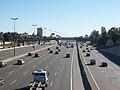
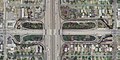
Basketweave on Highway 401 in Toronto

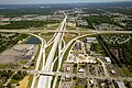
'The Transfer' on Highway 401 near Toronto Pearson Airport (top of image). 43°38′54″N 79°38′14″W / 43.648373°N 79.637085°W

Express to collector transfer on Highway 401

Collector–express roadway configuration on Highway 401
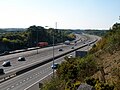
M20 motorway near Maidstone, England, showing separated local express lanes

Express and local lanes of Leningradsky Prospekt in Moscow

Express and local lanes, M-30 circular highway in Madrid, Spain, east section
Local–express lanes on Interstate 270 in Montgomery County, Maryland
A1 motorway through Novi Sad, Serbia

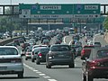
Garden State Parkway split into local and express lanes in Sayreville, New Jersey


Example of cloverleaf interchanges[]
A cloverleaf interchange may have collector–distributor lanes on a freeway or expressway to handle entering and exiting traffic. Usually, this lane will begin as an entrance-only ramp initially, but it will sometimes become a main lane or possibly an exit-only lane. The purpose of this lane is to facilitate traffic to the freeway exits and from the freeway entrances.


See also[]
- Frontage road
References[]
- ^ VDOT: Braided Ramp Demo. YouTube (2009-02-26). Retrieved on 2013-07-16.
- ^ I-5 196th Braided Ramp animation. YouTube (2010-12-02). Retrieved on 2013-07-16.
- ^ WSDOT - Project - I-405 – NE 8th St to SR 520 Braided Ramps – Interchange Improvements - Complete May 2012 Archived 2010-07-10 at the Wayback Machine. Wsdot.wa.gov. Retrieved on 2013-07-16.
- ^ ftp://ftp.dot.state.tx.us/pub/txdot-info/rti/psr/5105.pdf
- ^ TxDOT IH-10 Section 3. PGAL. Retrieved on 2013-07-16.
- ^ State Route 180 Braided Ramps Project. Dot.ca.gov. Retrieved on 2013-07-16.
- ^ Tele Atlas. "Driving directions to Unknown road". Google Maps. Mountain View, U.S.A.: Google Maps. Retrieved 2009-04-30.
- ^ Tele Atlas. "Driving directions to King's Hwy 401/MacDonald-Cartier Fwy/Hwy of Heroes". Google Maps. Mountain View, U.S.A.: Google Maps. Retrieved 2009-04-28.
- ^ Tele Atlas. "Driving directions to King's Hwy 401/MacDonald-Cartier Fwy". Google Maps. Mountain View, U.S.A.: Google Maps. Retrieved 2009-04-28.
- ^ "HIGHWAY 410 COLLECTOR LANES, BRAMPTON – Bot Construction Group". www.botconstruction.ca. Retrieved 2021-09-20.
External links[]
 Media related to Local-express lanes at Wikimedia Commons
- Road traffic management
- Types of roads