Parkway

A parkway is a landscaped thoroughfare.[1] The term is particularly used for a roadway in a park or connecting to a park from which trucks and other heavy vehicles are excluded.[1]
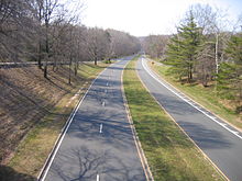
Over the years, many different types of roads have been labeled parkways. The term may be used to describe city streets as narrow as 2 lanes with a landscaped median, wide landscaped setbacks, or both.
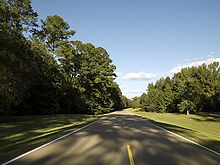
The term has also been applied to scenic highways and to limited-access roads more generally. Many parkways originally intended for scenic, recreational driving have evolved into major urban and commuter routes.
United States[]

Scenic roads[]
The first parkways in the United States were developed during the late 19th century by landscape architects Frederick Law Olmsted and Calvert Vaux as roads that separated pedestrians, bicyclists, equestrians, and horse carriages, such as the Eastern Parkway, which is credited as the world's first parkway,[2] and Ocean Parkway in the New York City borough of Brooklyn. The terminology "parkway" to define this type of road was coined by Calvert Vaux and Frederick Law Olmsted in their proposal to link city and suburban parks with "pleasure roads".
In Buffalo, New York, Olmsted and Vaux used parkways with landscaped medians and setbacks to create the first interconnected park and parkway system in the United States.[3] Bidwell Parkway and Chapin Parkway are 200 foot wide city streets with only one lane for cars in each direction and broad landscaped medians that provide a pleasant, shaded route to the park and serve as mini-parks within the neighborhood.[4]
Other parkways, such as Park Presidio Boulevard in San Francisco, California,[5] were designed to serve larger volumes of traffic.
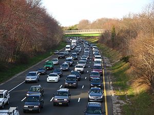
During the early 20th century, the meaning of the word was expanded to include limited-access highways designed for recreational driving of automobiles, with landscaping. These parkways originally provided scenic routes without very slow or commercial vehicles, at grade intersections, or pedestrian traffic. Examples are the Merritt Parkway in Connecticut and the Vanderbilt Motor Parkway in New York. But their success led to more development, expanding a city's boundaries, eventually limiting the parkway's recreational driving use. The Arroyo Seco Parkway between Downtown Los Angeles and Pasadena, California is an example of lost pastoral aesthetics. It and others have become major commuting routes, while retaining the name "parkway".
Early high speed roads[]
In New York City, construction on the Long Island Motor Parkway (Vanderbilt Parkway) began in 1906 and planning for the Bronx River Parkway in 1907. In the 1920s, the New York City Metropolitan Area's parkway system grew under the direction of Robert Moses, the president of the New York State Council of Parks and Long Island State Park Commission, who used parkways to create and access state parks, especially for city dwellers. As Commissioner of New York City Parks under Mayor LaGuardia, he extended the parkways to the heart of the city, creating and linking its parks to the greater metropolitan systems.
Most of the New York metropolitan parkways were designed by Gilmore Clark. The famed "Gateway to New England" Merritt Parkway in Connecticut was designed in the 1930s as a pleasurable alternative for affluent locals to the congested Boston Post Road, running through forest with each bridge designed uniquely to enhance the scenery. Another example is the Sprain Brook Parkway from lower-Westchester to become the Taconic State Parkway to Chatham, New York. Landscape architect George Kessler designed extensive parkway systems for Kansas City, Missouri; Memphis, Tennessee; Indianapolis; and other cities at the beginning of the 20th century.
New Deal roads[]
In the 1930s, as part of the New Deal the U.S. federal government constructed National Parkways designed for recreational driving and to commemorate historic trails and routes. These divided four-lane parkways have lower speed limits and are maintained by the National Park Service. An example is the Civilian Conservation Corps (CCC) built Blue Ridge Parkway in the Appalachian Mountains of North Carolina and Virginia.
Others are: Skyline Drive in Virginia; the Natchez Trace Parkway in Mississippi, Alabama, and Tennessee; and the Colonial Parkway in eastern Virginia's Historic Triangle area.[6] The George Washington Memorial Parkway and the Clara Barton Parkway, running along the Potomac River near Washington, D.C. and Alexandria, Virginia, were also constructed during this era.
Post-war parkways[]
In Kentucky the term "parkway" designates a controlled-access highway in the Kentucky Parkway system, with nine built in the 1960s and 1970s. They were toll roads until the construction bonds were repaid; the last of these roads to charge tolls became freeways in 2006.
The Arroyo Seco Parkway from Pasadena to Los Angeles, built in 1940, was the first segment of the vast Southern California freeway system. It became part of State Route 110 and was renamed the Pasadena Freeway. A 2010 restoration of the freeway brought the Arroyo Seco Parkway designation back.

In the New York metropolitan area, contemporary parkways are predominantly controlled-access highways restricted to non-commercial traffic, excluding trucks and tractor-trailers. Some have low overpasses that also exclude buses. The Vanderbilt Parkway, an exception in western Suffolk County, is a surviving remnant of the Long Island Motor Parkway that became a surface street, no longer with controlled-access or non-commercial vehicle restrictions. The Palisades Interstate Parkway is a post-war parkway that starts at the George Washington Bridge, heads north through New Jersey, continuing through Rockland and Orange counties in New York. The Palisades Parkway was built to allow for a direct route from New York City to Harriman State Park.
In New Jersey, the Garden State Parkway, connecting the northern part of the state with the Jersey Shore, is restricted to buses and non-commercial traffic north of the Route 18 interchange, but trucks are permitted south of this point. It is one of the busiest toll roads in the country.[7]
In the Pittsburgh region, two of the major Interstates are referred to informally as parkways. The Parkway East (I-376, formally the Penn-Lincoln Parkway) connects Downtown Pittsburgh to Monroeville, Pennsylvania. The Parkway West (I-376) runs through the Fort Pitt Tunnel and links Downtown to Pittsburgh International Airport, southbound I-79, Imperial, Pennsylvania, and westbound US 22/US 30. The Parkway North (I-279) connects Downtown to Franklin Park, Pennsylvania and northbound I-79.
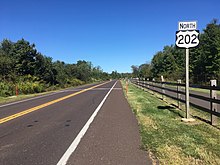
In the suburbs of Philadelphia, U.S. Route 202 follows an at-grade parkway alignment known as the "U.S. Route 202 Parkway" between Montgomeryville and Doylestown. The parkway varies from two to four lanes in width, has 5-foot-wide (1.5 m) shoulders, a 12-foot-wide (3.7 m) walking path called the US 202 Parkway Trail on the side, and a 40 mph (64 km/h) speed limit. The parkway opened in 2012 as a bypass of a section of US 202 between the two towns; it had originally been proposed as a four-lane freeway before funding for the road was cut.[8][9][10]
In Minneapolis, the Grand Rounds Scenic Byway system has 50 miles (80 km) of streets designated as parkways. These are not freeways; they have a slow 25-mile-per-hour (40 km/h) speed limit, pedestrian crossings, and stop signs.[11][12]
In Cincinnati, parkways are major roads which trucks are prohibited from using. Some Cincinnati parkways, such as Columbia Parkway, are high-speed, limited-access roads, while others, such as Central Parkway, are multi-lane urban roads without controlled access. Columbia Parkway carries US-50 traffic from downtown towards east-side suburbs of Mariemont, Anderson, and Milford, and is a limited access road from downtown to the Village of Mariemont.
In Boston, parkways are generally four to six lanes wide but are not usually controlled access. They are highly trafficked in most cases, transporting people between neighborhoods quicker than a typical city street. Many of them serve as principal arterials and some (like Storrow Drive, Memorial Drive, the Alewife Brook Parkway and the VFW Parkway) have evolved into regional commuter routes.
Canada[]
"Parkway" is used in the names of many Canadian roads, including major routes through national parks, scenic drives, major urban thoroughfares, and even regular freeways that carry commercial traffic.
Parkways in the National Capital Region are administered by the National Capital Region (Canada). However, some of them are named "drive" or "driveway".
The term in Canada is also applied to multi-use paths and greenways used by walkers and cyclists.[13][14]
- Airport Parkway (Ottawa)
- Aviation Parkway (Ottawa)
- Colonel By Drive in Ottawa, Ontario
- Conestoga Parkway in Kitchener, Ontario
- Don Valley Parkway in Toronto, Ontario
- in Bolton, Ontario
- Erin Mills Parkway in Mississauga, Ontario
- in Halifax, Nova Scotia
- Hanlon Expressway in Guelph, Ontario
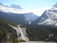
- Icefields Parkway in Alberta
- Island Park Drive in Ottawa, Ontario
- Lauzon Parkway in Windsor, Ontario
- Lincoln M. Alexander Parkway in Hamilton, Ontario
- Niagara Parkway in Southern Ontario
- Ojibway Parkway in Windsor, Ontario
- Queen Elizabeth Driveway in Ottawa, Ontario
- Red Hill Valley Parkway in Hamilton, Ontario
- Sir John A. Macdonald Parkway in Eastern Ontario
- The Parkway in St. John's, Newfoundland and Labrador
- Thousand Islands Parkway in Eastern Ontario
United Kingdom[]
Peterborough[]
The city of Peterborough has roads branded as "parkways" which provide routes for much through traffic and local traffic. The majority are dual carriageways, with many of their junctions numbered. Five main parkways form an orbital outer ring road. Three parkways serve settlements.
Plymouth[]
In the City of Plymouth, the A38 is called "The Parkway" and bisects a rural belt of the local authority area, which coincides with the geographical centre; it has two junctions to enter the downtown part of the city.
Australia[]
Australian Capital Territory[]
The Australian Capital Territory uses the term "parkway" to refer to roadways of a standard approximately equivalent to what would be designated as an "expressway", "freeway", or "motorway" in other areas. Parkways generally have multiple lanes in each direction of travel, no intersections (crossroads are accessed by interchanges), high speed limits, and are of dual carriageway design (or have high crash barriers on the median).[15]
Victoria[]
Victoria uses the term "parkway" to sometimes refer to smaller local access roads that travel through parkland. Unlike other uses of the term, these parkways are not high-speed routes but may still have some degree of limited access.
Other countries[]

Singapore uses the term "parkway" as an alternative to "expressway". As such, parkways are also dual carriageways with high speed limits and interchanges. The East Coast Parkway is currently[when?] the only expressway in Singapore that uses this terminology.
In Russia, long, broad (multi-lane) and beautified thoroughfares are referred to as prospekts.
See also[]
- Central reservation
- Green belt
- Road verge
- Linear park
- Prospekt (street)
References[]
- ^ Jump up to: a b "parkway."Webster's Third New International Dictionary, Unabridged. Merriam-Webster, 2002. http://unabridged.merriam-webster.com (14 Apr. 2007).
- ^ "Eastern Parkway Highlights : NYC Parks".
- ^ "Olmsted's Buffalo Park System and Its Stewards | Frederick Law Olmsted | PBS". Olmsted's Buffalo Park System and Its Stewards | Frederick Law Olmsted | PBS. Retrieved 2019-07-10.
- ^ "Your Parkways | Caring for 850 acres of Buffalo's Olmsted Park System". Buffalo Olmsted Parks. Retrieved 2019-07-10.
- ^ Alexander, Jeanne. "History of Park Presidio Boulevard". Archived from the original on 2012-10-03.
- ^ Thornton, Tim; Howell, Isak. "Parkway's Past Haunts Its Future". Archived from the original on October 9, 2012.
- ^ "Title 16. Department of Transportation; Chapter 32. Truck Access" (PDF). New Jersey Department of Transportation. Archived from the original (PDF) on September 20, 2008. Retrieved August 13, 2010.
- ^ Mucha, Peter (December 3, 2012). "New Route 202 parkway opens today". The Philadelphia Inquirer. Retrieved December 3, 2012.
- ^ Savana, Freda R. (March 2, 2008). "Make way for the 202 Parkway". The Intelligencer.
- ^ Kristofic, Christina (November 1, 2007). "PennDOT to hold meetings on noise from parkway". The Intelligencer.
- ^ "Information Center: About the Grand Rounds". Archived from the original on 2015-02-14. Retrieved 2007-12-18.
- ^ "Second Ward, Minneapolis: Traffic Calming Event". Retrieved 2007-12-18.
- ^ BC Parkway, Vancouver, British Columbia, Canada
- ^ Welland Canals Parkway Trail, Canada
- ^ EPBC Referral - Majura Parkway to DEWHA (Revision 1) Archived 2013-04-11 at the Wayback Machine, SMEC, Page 9, 19 August 2009
External links[]
| Look up parkway in Wiktionary, the free dictionary. |
- The Straight Dope "Why do we drive on the parkway and park on the driveway?"
- Parkways
- Landscape
- Types of roads
- Environmental design
- Limited-access roads
- Urban studies and planning terminology