Leichhardt County

From Wikipedia, the free encyclopedia

Map all coordinates using: OpenStreetMap 
Download coordinates as: KML
Leichhardt
New South Wales
Leichhardt NSW.png
Location in New South Wales
Lands administrative divisions around Leichhardt:
Narran Finch Baradine
Clyde Leichhardt Baradine
Gregory Ewenmar Gowen

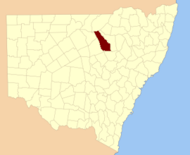
Leichhardt County is one of the 141 Cadastral divisions of New South Wales. It is located south of the Namoi River and includes land on both sides of the Castlereagh River, including Coonamble.

Leichhardt County was named in honour of the Prussian naturalist and explorer Friedrich Wilhelm Ludwig Leichhardt (1813-1848).[1]

Parishes within the county[]

A full list of parishes found within this county; their current LGA and mapping coordinates to the approximate centre of each location is as follows:

Parish LGA Coordinates
Walgett Shire 30°05′54″S 147°50′04″E / 30.09833°S 147.83444°E / -30.09833; 147.83444 (Aberfoyle)
Walgett Shire 30°13′54″S 147°54′04″E / 30.23167°S 147.90111°E / -30.23167; 147.90111 (Amos)
Coonamble Shire 31°11′54″S 148°40′04″E / 31.19833°S 148.66778°E / -31.19833; 148.66778 (Baronne)
Coonamble Shire 30°51′54″S 148°24′04″E / 30.86500°S 148.40111°E / -30.86500; 148.40111 (Bimble)
Walgett Shire 30°13′54″S 147°44′04″E / 30.23167°S 147.73444°E / -30.23167; 147.73444 (Bogewang)
Walgett Shire 30°11′54″S 147°46′04″E / 30.19833°S 147.76778°E / -30.19833; 147.76778 (Borgara)
Walgett Shire 30°07′54″S 147°36′04″E / 30.13167°S 147.60111°E / -30.13167; 147.60111 (Brewan)
Buchanan Coonamble Shire 31°05′54″S 148°48′04″E / 31.09833°S 148.80111°E / -31.09833; 148.80111 (Buchanan)
Coonamble Shire 31°07′54″S 148°18′04″E / 31.13167°S 148.30111°E / -31.13167; 148.30111 (Budgeon)
Coonamble Shire 30°27′54″S 148°20′04″E / 30.46500°S 148.33444°E / -30.46500; 148.33444 (Bulgah)
Coonamble Shire 30°41′54″S 148°29′04″E / 30.69833°S 148.48444°E / -30.69833; 148.48444 (Bulgogar)
Coonamble Shire 30°37′54″S 148°20′04″E / 30.63167°S 148.33444°E / -30.63167; 148.33444 (Bullarora)
Calga Coonamble Shire 31°00′54″S 148°42′04″E / 31.01500°S 148.70111°E / -31.01500; 148.70111 (Calga)
Coonamble Shire 31°11′54″S 148°18′04″E / 31.19833°S 148.30111°E / -31.19833; 148.30111 (Cambara)
Coonamble Shire 30°47′54″S 148°28′04″E / 30.79833°S 148.46778°E / -30.79833; 148.46778 (Campbell)
Coonamble Shire 30°57′54″S 148°02′04″E / 30.96500°S 148.03444°E / -30.96500; 148.03444 (Carrabear)
Coonamble Shire 31°12′54″S 148°45′04″E / 31.21500°S 148.75111°E / -31.21500; 148.75111 (Carwell)
Castlereagh Walgett Shire 30°17′54″S 147°54′04″E / 30.29833°S 147.90111°E / -30.29833; 147.90111 (Castlereagh)
Coonamble Shire 30°27′54″S 148°24′04″E / 30.46500°S 148.40111°E / -30.46500; 148.40111 (Collinouie)
Walgett Shire 30°15′54″S 148°04′04″E / 30.26500°S 148.06778°E / -30.26500; 148.06778 (Colmia)
Walgett Shire 30°19′54″S 147°58′04″E / 30.33167°S 147.96778°E / -30.33167; 147.96778 (Colomy)
Coonamble Shire 30°41′54″S 148°04′04″E / 30.69833°S 148.06778°E / -30.69833; 148.06778 (Conimbia)
Coonamble Shire 30°27′54″S 148°14′04″E / 30.46500°S 148.23444°E / -30.46500; 148.23444 (Cooeyah Warrah)
Coonamble Coonamble Shire 30°57′54″S 148°20′04″E / 30.96500°S 148.33444°E / -30.96500; 148.33444 (Coonamble)
Coonamble Shire 30°55′08″S 148°37′08″E / 30.91889°S 148.61889°E / -30.91889; 148.61889 (Coonamoona)
Walgett Shire 30°27′54″S 148°08′04″E / 30.46500°S 148.13444°E / -30.46500; 148.13444 (Dahomey)
Walgett Shire 30°21′54″S 147°54′04″E / 30.36500°S 147.90111°E / -30.36500; 147.90111 (Devon)
Coonamble Shire 30°51′54″S 148°14′04″E / 30.86500°S 148.23444°E / -30.86500; 148.23444 (Dinoa)
Edgeroi Coonamble Shire 30°57′54″S 148°08′04″E / 30.96500°S 148.13444°E / -30.96500; 148.13444 (Edgeroi)
Coonamble Shire 31°07′54″S 148°30′04″E / 31.13167°S 148.50111°E / -31.13167; 148.50111 (Ellis)
Elongery Coonamble Shire 31°12′54″S 148°55′04″E / 31.21500°S 148.91778°E / -31.21500; 148.91778 (Elongery)
Coonamble Shire 31°03′54″S 148°14′04″E / 31.06500°S 148.23444°E / -31.06500; 148.23444 (Eulah)
Walgett Shire 30°05′54″S 148°06′04″E / 30.09833°S 148.10111°E / -30.09833; 148.10111 (Euroka)
Coonamble Shire 30°45′54″S 148°46′04″E / 30.76500°S 148.76778°E / -30.76500; 148.76778 (Geelnoy)
Coonamble Shire 30°51′54″S 148°28′04″E / 30.86500°S 148.46778°E / -30.86500; 148.46778 (Gelambula)
Walgett Shire 30°21′54″S 147°48′04″E / 30.36500°S 147.80111°E / -30.36500; 147.80111 (Gidgerygah)
Walgett Shire 30°23′54″S 148°14′04″E / 30.39833°S 148.23444°E / -30.39833; 148.23444 (Gidginbilla)
Coonamble Shire 30°46′39″S 148°32′16″E / 30.77750°S 148.53778°E / -30.77750; 148.53778 (Gilgooma)
Coonamble Shire 31°11′54″S 148°22′04″E / 31.19833°S 148.36778°E / -31.19833; 148.36778 (Gilguldry)
Walgett Shire 30°25′54″S 147°50′04″E / 30.43167°S 147.83444°E / -30.43167; 147.83444 (Gilwarny)
Coonamble Shire 31°06′55″S 148°52′40″E / 31.11528°S 148.87778°E / -31.11528; 148.87778 (Goorianawa)
Coonamble Shire 30°25′54″S 147°58′04″E / 30.43167°S 147.96778°E / -30.43167; 147.96778 (Gungalman North)
Coonamble Shire 30°31′54″S 148°02′04″E / 30.53167°S 148.03444°E / -30.53167; 148.03444 (Gungalman)
Walgett Shire 30°11′54″S 148°10′04″E / 30.19833°S 148.16778°E / -30.19833; 148.16778 (Gunna)
Coonamble Shire 30°25′54″S 148°22′04″E / 30.43167°S 148.36778°E / -30.43167; 148.36778 (Keadool)
Walgett Shire 30°15′54″S 147°50′04″E / 30.26500°S 147.83444°E / -30.26500; 147.83444 (Kidgar)
Coonamble Shire 31°03′54″S 148°35′04″E / 31.06500°S 148.58444°E / -31.06500; 148.58444 (Magometon)
Coonamble Shire 30°25′54″S 148°18′04″E / 30.43167°S 148.30111°E / -30.43167; 148.30111 (Matouree)
Coonamble Shire 30°51′54″S 148°04′04″E / 30.86500°S 148.06778°E / -30.86500; 148.06778 (Mogil)
Coonamble Shire 31°07′54″S 148°24′04″E / 31.13167°S 148.40111°E / -31.13167; 148.40111 (Moolambong)
Walgett Shire 30°17′54″S 148°14′04″E / 30.29833°S 148.23444°E / -30.29833; 148.23444 (Moora)
Coonamble Shire 30°57′54″S 148°24′04″E / 30.96500°S 148.40111°E / -30.96500; 148.40111 (Moorambilla)
Walgett Shire 30°07′54″S 147°44′04″E / 30.13167°S 147.73444°E / -30.13167; 147.73444 (Mourabie)
Coonamble Shire 30°41′54″S 148°10′04″E / 30.69833°S 148.16778°E / -30.69833; 148.16778 (Mowlma)
Coonamble Shire 30°57′54″S 148°30′04″E / 30.96500°S 148.50111°E / -30.96500; 148.50111 (Mundare)
Coonamble Shire 30°59′54″S 148°32′04″E / 30.99833°S 148.53444°E / -30.99833; 148.53444 (Mundare)
Coonamble Shire 31°05′54″S 148°40′04″E / 31.09833°S 148.66778°E / -31.09833; 148.66778 (Mungery)
Coonamble Shire 30°31′54″S 147°56′04″E / 30.53167°S 147.93444°E / -30.53167; 147.93444 (Munna Munna)
Coonamble Shire 30°58′26″S 148°42′27″E / 30.97389°S 148.70750°E / -30.97389; 148.70750 (Murraiman)
Coonamble Shire 31°00′54″S 148°48′04″E / 31.01500°S 148.80111°E / -31.01500; 148.80111 (Narratigah)
Coonamble Shire 30°51′22″S 148°33′54″E / 30.85611°S 148.56500°E / -30.85611; 148.56500 (Nebea)
Coonamble Shire 30°27′54″S 147°56′04″E / 30.46500°S 147.93444°E / -30.46500; 147.93444 (Nedgera)
Coonamble Shire 31°03′54″S 148°06′04″E / 31.06500°S 148.10111°E / -31.06500; 148.10111 (Neinby)
Coonamble Shire 30°53′54″S 148°10′04″E / 30.89833°S 148.16778°E / -30.89833; 148.16778 (Nelgowrie)
Coonamble Shire 30°41′54″S 147°56′04″E / 30.69833°S 147.93444°E / -30.69833; 147.93444 (Nimbia)
Coonamble Shire 30°47′54″S 148°08′04″E / 30.79833°S 148.13444°E / -30.79833; 148.13444 (Ningear)
Coonamble Shire 30°59′54″S 148°35′04″E / 30.99833°S 148.58444°E / -30.99833; 148.58444 (Noonbar)
Walgett Shire 30°21′54″S 148°05′04″E / 30.36500°S 148.08444°E / -30.36500; 148.08444 (Nugal)
Coonamble Shire 30°35′54″S 148°08′04″E / 30.59833°S 148.13444°E / -30.59833; 148.13444 (Oural)
Coonamble Shire 31°08′54″S 148°51′04″E / 31.14833°S 148.85111°E / -31.14833; 148.85111 (Parmiduan)
Coonamble Shire 30°35′54″S 147°54′04″E / 30.59833°S 147.90111°E / -30.59833; 147.90111 (Pier Pier)
Coonamble Shire 31°06′54″S 148°46′04″E / 31.11500°S 148.76778°E / -31.11500; 148.76778 (Quanda Quanda)
Coonamble Shire 31°01′54″S 148°18′04″E / 31.03167°S 148.30111°E / -31.03167; 148.30111 (Quonmoona)
Walgett Shire 30°09′54″S 147°58′04″E / 30.16500°S 147.96778°E / -30.16500; 147.96778 (Sussex)
Coonamble Shire 30°43′54″S 148°22′04″E / 30.73167°S 148.36778°E / -30.73167; 148.36778 (Tahrone)
Coonamble Shire 31°05′54″S 148°14′04″E / 31.09833°S 148.23444°E / -31.09833; 148.23444 (Tallegar)
Coonamble Shire 30°37′54″S 148°41′04″E / 30.63167°S 148.68444°E / -30.63167; 148.68444 (Terembone)
Coonamble Shire 30°55′54″S 149°48′04″E / 30.93167°S 149.80111°E / -30.93167; 149.80111 (Teridgerie)
Coonamble Shire 30°37′54″S 148°26′04″E / 30.63167°S 148.43444°E / -30.63167; 148.43444 (Thara)
Walgett Shire 30°09′54″S 148°04′04″E / 30.16500°S 148.06778°E / -30.16500; 148.06778 (Toloora)
Coonamble Shire 30°57′54″S 148°14′04″E / 30.96500°S 148.23444°E / -30.96500; 148.23444 (Tooloon)
Coonamble Shire 30°33′54″S 148°02′04″E / 30.56500°S 148.03444°E / -30.56500; 148.03444 (Toora)
Walgett Shire 30°15′54″S 147°58′04″E / 30.26500°S 147.96778°E / -30.26500; 147.96778 (Trielmon)
Walgett Shire 30°03′54″S 148°00′04″E / 30.06500°S 148.00111°E / -30.06500; 148.00111 (Ularbie)
Coonamble Shire 31°12′54″S 148°30′04″E / 31.21500°S 148.50111°E / -31.21500; 148.50111 (Ulundry)
Coonamble Shire 30°50′28″S 148°42′42″E / 30.84111°S 148.71167°E / -30.84111; 148.71167 (Urawilkie)
Walgett Shire 30°07′54″S 147°54′04″E / 30.13167°S 147.90111°E / -30.13167; 147.90111 (Waddiwong)
Coonamble Shire 30°36′54″S 148°35′04″E / 30.61500°S 148.58444°E / -30.61500; 148.58444 (Walcha Council)
Walla Walla Coonamble Shire 31°08′54″S 148°34′04″E / 31.14833°S 148.56778°E / -31.14833; 148.56778 (Walla Walla)
Coonamble Shire 31°12′54″S 148°50′04″E / 31.21500°S 148.83444°E / -31.21500; 148.83444 (Wambelong)
Coonamble Shire 30°42′54″S 148°39′04″E / 30.71500°S 148.65111°E / -30.71500; 148.65111 (Warraba East)
Coonamble Shire 30°55′54″S 148°02′04″E / 30.93167°S 148.03444°E / -30.93167; 148.03444 (Warrabah)
Walgett Shire 30°17′54″S 148°08′04″E / 30.29833°S 148.13444°E / -30.29833; 148.13444 (Warragan)
Walgett Shire 30°17′54″S 147°44′04″E / 30.29833°S 147.73444°E / -30.29833; 147.73444 (Warren Downs)
Coonamble Shire 30°57′54″S 148°28′04″E / 30.96500°S 148.46778°E / -30.96500; 148.46778 (Warrena)
Weetaliba Coonamble Shire 30°42′54″S 148°34′04″E / 30.71500°S 148.56778°E / -30.71500; 148.56778 (Weetaliba)
Coonamble Shire 30°47′15″S 148°38′33″E / 30.78750°S 148.64250°E / -30.78750; 148.64250 (Willaga)
Coonamble Shire 30°09′54″S 148°12′04″E / 30.16500°S 148.20111°E / -30.16500; 148.20111 (Wingadee)
Coonamble Shire 30°27′54″S 148°12′04″E / 30.46500°S 148.20111°E / -30.46500; 148.20111 (Wingadee)
Coonamble Shire 30°29′54″S 148°34′04″E / 30.49833°S 148.56778°E / -30.49833; 148.56778 (Winnaba)
Coonamble Shire 30°39′54″S 148°14′04″E / 30.66500°S 148.23444°E / -30.66500; 148.23444 (Woolingar)
Coonamble Shire 31°12′54″S 148°34′04″E / 31.21500°S 148.56778°E / -31.21500; 148.56778 (Worinjerong)
Coonamble Shire 30°45′54″S 148°14′04″E / 30.76500°S 148.23444°E / -30.76500; 148.23444 (Yarragoora)
Coonamble Shire 30°47′54″S 148°02′04″E / 30.79833°S 148.03444°E / -30.79833; 148.03444 (Yarrayin)
Coonamble Shire 30°51′54″S 148°20′04″E / 30.86500°S 148.33444°E / -30.86500; 148.33444 (Yoee)
Walgett Shire 30°03′54″S 147°56′04″E / 30.06500°S 147.93444°E / -30.06500; 147.93444 (Youendah)
Coonamble Shire 30°47′54″S 148°22′04″E / 30.79833°S 148.36778°E / -30.79833; 148.36778 (Yuma)

References[]

  1. ^ "Leichhardt". Geographical Names Register (GNR) of NSW. Geographical Names Board of New South Wales. Retrieved 4 August 2013. Edit this at Wikidata
Retrieved from ""