Leprozengracht
 Leprozengracht looking northeast to the Mozes en Aäronkerk on the Houtgracht | |||
 | |||
| Location | Amsterdam | ||
|---|---|---|---|
| Coordinates | 52°22′02″N 4°54′08″E / 52.367340°N 4.902323°ECoordinates: 52°22′02″N 4°54′08″E / 52.367340°N 4.902323°E | ||
| Southeast end | Amstel | ||
| To | Houtgracht | ||
| Construction | |||
| Inauguration | 1593 | ||
| Demolished | 1882 | ||


The Leprozengracht was a canal in Amsterdam that defined one side of the Vlooyenburg island. Leprozengracht and the connected Houtgracht canal were filled in 1882 to form the Waterlooplein.
History[]
The Sint Anthoniusgasthuis, or Sint Nicolaasgasthuis, a leper house, was established on the land between Sint Anthoniesdijk and Amstel in the 14th century.[1] In the late 16th century it was decided to expand the old city of Amsterdam by creating a new island in this area. The new island was called Vlooyenburg, a reference to the regular flooding of the area from the Amstel, and was surrounded by the Amstel, Leprozengracht, Houtgracht and Verwerfsgracht (Zwanenburgwal).[2] With the expansion, the leper house came to be within the city, and gave its name to the canal.[1] The canal was also known as the Leprozen Graft, Leprozenburgwal and Turfgracht.[3] It was crossed by the Muiderbrug along the Amstel bank.[4]
Vlooienburg was raised up during the second expansion of Amsterdam between 1592 and 1596 as a place to store wood, and blocks of houses were soon added. From the start, three Portuguese Jewish congregations built their synagogues on the island. The congregations united in 1639.[5] In the 1870s the houses along the canal were occupied by, among others, a furniture maker, teacher of religion, insurance broker, kosher cafe-restaurant, corn cutter and tailor.[6] Between 1837 and 1841 a church was built opposite the end of the canal dedicated to Saint Anthony of Padua, designed by Tilman-François Suys. The church became known as the Mozes en Aäron-kerk.[7]
The city council decided to fill in the Leprozengracht and Houtgracht on 28 January 1874. Both canals were filled in 1882.[8] The park that replaced the canals was officially named Waterlooplein in December 1883. It was made into a Jewish market.[2] The street traders from around Jodenbreestraat had to move to the new square. They were opposed to the move, thinking the square was too windy and no customers would come.[6] The former island is now the home of the Amsterdam "Stopera" building complex.[5]
Gallery[]

The Naarderveer on the Amstel on the corner with the Leprozengracht. On the right a small part of the Blauwbrug. c. 1659
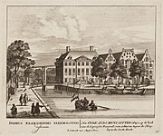
The Oudezijds Huiszittenhuis on the Leprozengracht with the Arsenaal on the right. Seen along the Houtgracht to the Leprozengracht, with the Portuguese-Israelite Synagogue in the distance. c. 1710

Leprozengracht looking southwest towards Zwanenburgerstraat Gerrit Lamberts 1830

Houtgracht looking southeast to Mozes en Aäronkerk and Leprozengracht


Notes[]
| Wikimedia Commons has media related to Leprozengracht. |
Sources[]
- "400 jaar Amsterdamse grachten: De Houtgracht en Leprozengracht", De Echo, 20 February 2013, retrieved 2019-07-28
- "Amsterdam, Vlooienburg quarter", Spinozaweb, retrieved 2019-07-28
- J. Kruizinga Gerrit Vermeer (2002), "Leprozengracht", XYZ van Amsterdam, retrieved 2019-07-28
- "Leprozengracht", Adamlink, retrieved 2019-07-28
- "Leprozengracht", Joodsamsterdam (in Dutch), 17 December 2016, retrieved 2019-07-28
- "Muiderbrug in de Binnen Amstel over de Leprozengracht", Alle Amsterdamse bruggen, retrieved 2019-07-28
- Theo Bakker, Vlooienburg & Zwanenburg (PDF), retrieved 2019-07-28
- Former canals in Amsterdam