Lhee
Lhee | |
|---|---|
Town | |
 | |
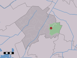 The village (dark red) and the statistical district (light green) of Lhee in the municipality of Westerveld. | |
| Coordinates: 52°49′42″N 6°23′37″E / 52.82833°N 6.39361°ECoordinates: 52°49′42″N 6°23′37″E / 52.82833°N 6.39361°E | |
| Country | Netherlands |
| Province | Drenthe |
| Municipality | Westerveld |
| Population (1 January 2005) | |
| • Total | 340 |
| Time zone | UTC+1 (CET) |
| • Summer (DST) | UTC+2 (CEST) |
| Postal code | 7991 |
| Dialing code | 0521 |

Lhee is a town in the Dutch province of Drenthe. It is a part of the municipality of Westerveld, and lies about 13 kilometres (8.1 mi) north of Hoogeveen.
The statistical area "Lhee", which can also include the surrounding countryside, has a population of around 340.[1]
References[]
- ^ Statistics Netherlands (CBS), Statline: Kerncijfers wijken en buurten 2003-2005. As of 1 January 2005.
This Drenthe location article is a stub. You can help Wikipedia by . |
Categories:
- Populated places in Drenthe
- Westerveld
- Drenthe geography stubs