Westerveld
Westerveld | |
|---|---|
Municipality | |
 Town of Dwingeloo | |
 Flag Coat of arms | |
 Location in Drenthe | |
| Coordinates: 52°52′N 6°19′E / 52.867°N 6.317°ECoordinates: 52°52′N 6°19′E / 52.867°N 6.317°E | |
| Country | Netherlands |
| Province | Drenthe |
| Established | 1 January 1998[1] |
| Government | |
| • Body | Municipal council |
| • Mayor | (CDA) |
| Area | |
| • Total | 282.74 km2 (109.17 sq mi) |
| • Land | 278.35 km2 (107.47 sq mi) |
| • Water | 4.39 km2 (1.69 sq mi) |
| Elevation | 8 m (26 ft) |
| Population (January 2019)[5] | |
| • Total | 19,348 |
| • Density | 70/km2 (200/sq mi) |
| Time zone | UTC+1 (CET) |
| • Summer (DST) | UTC+2 (CEST) |
| Postcode | Parts of 7000 and 8000 range |
| Area code | 0521, 0561 |
| Website | gemeentewesterveld |

Westerveld (Dutch pronunciation: [ˌʋɛstərˈvɛlt] (![]() listen)) is a municipality in the northeastern Netherlands.
listen)) is a municipality in the northeastern Netherlands.
The municipality Westerveld was established in 1998 out of the municipalities of Diever, Dwingeloo, Havelte, and Vledder. Westerveld is crossed by a channel, the Drentsche Hoofdvaart. There are also two National Parks situated in the municipality, the Drents-Friese Wold and Dwingelerveld.
Population centres[]
- Boschoord
- Darp
- Diever
- Dieverbrug
- Doldersum
- Dwingeloo
- Eemster
- Frederiksoord
- Geeuwenbrug
- Havelte
- Havelterberg
- Leggeloo
- Lhee
- Lheebroek
- Nijensleek
- Oude Willem
- Uffelte
- Vledder
- Vledderveen
- Wapse
- Wapserveen
- Wateren
- Wilhelminaoord
- Wittelte
- Zorgvlied
Dwingeloo is a town halfway between Meppel and Assen. The radio telescope of the Dwingeloo Radio Observatory is located on the edge of the Dwingeloo Heath, 3 km (2 mi) south of the village.
Topography[]

Dutch Topographic map of the municipality of Westerveld, 2013.
Notable people[]

- Sicco Mansholt (1908 in Ulrum – 1995) politician, 4th President of the European Commission 1972-1973
- John Hugenholtz (1914 in Vledder – 1995) designer of race tracks and cars
- Jan Pol (born 1942 in Wateren) veterinarian, & TV Personality
- Jan Mulder (born 1943 in Diever) politician and Member of the European Parliament
- Klaske Hiemstra (born 1954 in Vledder) a West Frisian-language writer
- Maarten Treurniet (born 1959) film director, brought up in Dwingeloo [6]
- Merlijn Twaalfhoven (born 1976 in Wapserveen) Dutch composer
Sport[]
- Gerrit Postma (1894 in Vledderveen – 1969) discus thrower, competed at the 1928 Summer Olympics
- Tollien Schuurman (1913 in Zorgvlied – 1994) sprint runner, competed at the 1932 Summer Olympics
- Riëtte Fledderus (born 1977) retired volleyball player, competed at the 1996 Summer Olympics
Gallery[]

Hervormde Karke Dever
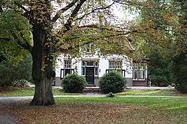
Dwingeloo - De Bork - Westeinde
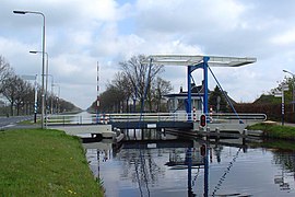
Drentsche Hoofdvaart, Uffelterbrug
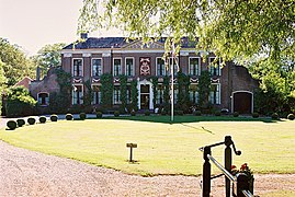
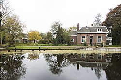
De havezate Oldengaerde te Dwingeloo


References[]
- ^ "Gemeentelijke indeling op 1 januari 1998" [Municipal divisions on 1 January 1998]. cbs.nl (in Dutch). CBS. Retrieved 11 October 2013.
- ^ "Samenstelling van het college van burgemeester en wethouders" [Members of the board of mayor and aldermen] (in Dutch). Gemeente Westerveld. Retrieved 12 October 2013.
- ^ "Kerncijfers wijken en buurten 2020" [Key figures for neighbourhoods 2020]. StatLine (in Dutch). CBS. 24 July 2020. Retrieved 19 September 2020.
- ^ "Postcodetool for 7981EL". Actueel Hoogtebestand Nederland (in Dutch). Het Waterschapshuis. Retrieved 12 October 2013.
- ^ "Bevolkingsontwikkeling; regio per maand" [Population growth; regions per month]. CBS Statline (in Dutch). CBS. 1 January 2019. Retrieved 1 January 2019.
- ^ IMDb Database retrieved 7 June 2019
External links[]
| show Places adjacent to Westerveld |
|---|

This Drenthe location article is a stub. You can help Wikipedia by . |
- Westerveld
- Municipalities of Drenthe
- Drenthe geography stubs