Ooststellingwerf
Ooststellingwerf
Ooststellingwarf (Stellingwerfs) | |
|---|---|
Municipality | |
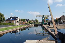 Lock in canal through Appelscha | |
 Flag Coat of arms | |
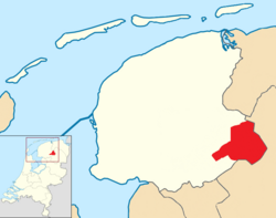 Location in Friesland | |
| Coordinates: 53°0′N 6°18′E / 53.000°N 6.300°ECoordinates: 53°0′N 6°18′E / 53.000°N 6.300°E | |
| Country | Netherlands |
| Province | Friesland |
| Government | |
| • Body | Municipal council |
| • Mayor | (CDA) |
| Area | |
| • Total | 226.11 km2 (87.30 sq mi) |
| • Land | 223.42 km2 (86.26 sq mi) |
| • Water | 2.69 km2 (1.04 sq mi) |
| Elevation | 7 m (23 ft) |
| Population (January 2019)[4] | |
| • Total | 25,497 |
| • Density | 114/km2 (300/sq mi) |
| Time zone | UTC+1 (CET) |
| • Summer (DST) | UTC+2 (CEST) |
| Postcode | 8420–8435 |
| Area code | 0516 |
| Website | www |

Ooststellingwerf (Dutch: [ˈoːststɛlɪŋˌʋɛrf] (![]() listen); Stellingwarfs: Ooststellingwarf) is a municipality in the province of Friesland in the northern Netherlands.
It is one of the municipalities of Friesland where the spoken language is not West Frisian; instead, Stellingwerfs, a dialect of Dutch Low Saxon, is spoken here.
listen); Stellingwarfs: Ooststellingwarf) is a municipality in the province of Friesland in the northern Netherlands.
It is one of the municipalities of Friesland where the spoken language is not West Frisian; instead, Stellingwerfs, a dialect of Dutch Low Saxon, is spoken here.
Population centres[]
Hamlets[]
The hamlets within the municipality are: , , , , , , , , , , , , (partially), , , , , , , , , , , , , , , (partially), , , Oude Willem (partially), (partially), , , , , , , , , , , , , (partially) and .
Topography[]

Dutch Topographic map of the municipality of Ooststellingwerf, June 2015
Notable people[]

Marrit Steenbergen, 2015
- Anne Vondeling (1916 in Appelscha – 1979) a Dutch politician
- Prof Dirk ter Haar FRSE FIP (1919 in Oosterwolde – 2002) an Anglo-Dutch physicist
- Piet Bergveld (born 1940 in Oosterwolde) a Dutch emeritus professor of biosensors, invented ISFET
Sport[]
- Joop Alberda (born 1952 in Oosterwolde) a retired volleyball coach
- Halbe Zijlstra (born 1969 in Oosterwolde) a retired Dutch politician
- Jan Kromkamp (born 1980 in Makkinga) a Dutch retired footballer with 316 club caps
- Sjoerd Hamburger (born 1983 in Oldeberkoop) a rower who competes in the single scull, competed in the 2008 and 2012 Summer Olympics
- Marrit Steenbergen (born 2000 in Ooststellingwerf) a Dutch competitive swimmer, gold medallist at the 2015 European Games
References[]
- ^ "College" [Executive board] (in Dutch). Gemeente Ooststellingwerf. Archived from the original on 27 September 2013. Retrieved 22 September 2013.
- ^ "Kerncijfers wijken en buurten 2020" [Key figures for neighbourhoods 2020]. StatLine (in Dutch). CBS. 24 July 2020. Retrieved 19 September 2020.
- ^ "Postcodetool for 8431LE". Actueel Hoogtebestand Nederland (in Dutch). Het Waterschapshuis. Retrieved 22 September 2013.
- ^ "Bevolkingsontwikkeling; regio per maand" [Population growth; regions per month]. CBS Statline (in Dutch). CBS. 1 January 2019. Retrieved 1 January 2019.
External links[]
 Media related to Ooststellingwerf at Wikimedia Commons
- Official website
| show Places adjacent to Ooststellingwerf |
|---|

| Authority control |
|
|---|
This Friesland location article is a stub. You can help Wikipedia by . |
Categories:
- Ooststellingwerf
- Municipalities of Friesland
- Friesland geography stubs