Lhuntse
Lhuentse | |
|---|---|
 | |
 Lhuentse Location in Bhutan | |
| Coordinates: 27°39′N 91°9′E / 27.650°N 91.150°ECoordinates: 27°39′N 91°9′E / 27.650°N 91.150°E | |
| Country | |
| District | Lhuntse District |
| Time zone | UTC+6 (BTT) |
| Climate | Cwb |
| Website | Official website |

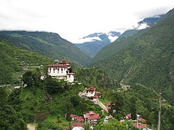
Lhuentse,[1] also Lhuntse or Lhuntshi,[2] is a town and headquarter of eponymous Lhuntse District in northeastern Bhutan. It is about 70 km from Mongar, 145 km from Trashigang and 452 km from the national capital Thimpu. Nearest airport is Yongphulla Airport 130 km away.
Lhuentse consists of eight Gewogs, namely Gangzur, Jaray, Kurtoe, Khoma, Maenbi, Maedtsho, Minjey, and Tsaenkhar.[3]
Development plans[]
It is also the site of proposed joint "India-Bhutan Lhuntse Advanced Landing Ground" (AGL) capable of handling large transport aircraft and fighter jets.
Tourism[]
It is the location of the Lhuentse Dzong, Bumdeling Wildlife Sanctuary in Trashiyangtse district is just to the northeast, and Tawang in India lies to the east.
Administration[]
The postal code for Lhuentse is 45001.[4]
See also[]
References[]
- ^ "Lhuentse district information". Archived from the original on 2009-02-21. Retrieved 2017-12-26.
- ^ "NGA GeoName Database". National Geospatial Intelligence Agency. Archived from the original on 2008-06-08. Retrieved 2008-07-05.
- ^ Wanggchuk, Lily (2017). Facts About Bhutan The Land of the Thunder Dragon. Bhutan: Absolute Bhutan Books. p. 338. ISBN 99936-760-0-4.
- ^ "Bhutan Post post codes list" (PDF). Archived from the original (PDF) on 2017-12-26. Retrieved 2017-12-26.
External links[]
| Wikimedia Commons has media related to Lhuntse (town). |
This Bhutan location article is a stub. You can help Wikipedia by . |
- Populated places in Bhutan
- Bhutan geography stubs