Limestone, Montana
Limestone, Montana | |
|---|---|
 Limestone, Montana | |
| Coordinates: 45°28′41″N 109°54′07″W / 45.47806°N 109.90194°WCoordinates: 45°28′41″N 109°54′07″W / 45.47806°N 109.90194°W | |
| Country | United States |
| State | Montana |
| County | Stillwater |
| Elevation | 5,535 ft (1,687 m) |
| Population | |
| • Total | 17 |
| Time zone | UTC-7 (Mountain (MST)) |
| • Summer (DST) | UTC-6 (MDT) |
| ZIP code | 59061 |
| Area code(s) | 406 |
| GNIS feature ID | 777090[2] |


Limestone is a ghost Town located in Stillwater County, Montana, United States.
The elevation is 5,535 feet. Limestone appears on the Meyer Mountain U.S. Geological Survey Map.
History[]
Limestone was a mining community situated along Lodgepole Creek and sat at the foot of Limestone Butte, for which the town was named. The town was small but busy. The post office operated at Limestone from 1910 to 1953. Today Limestone is a ghost town with a number of buildings left standing, including the former grocery store and post office.
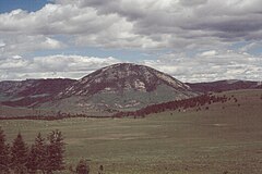
Limestone Butte, a laccolith of granite with a remnant of limestone at the crest.
References[]
- ^ "U.S. Census website". United States Census Bureau. Retrieved 2011-05-14.
- ^ "Limestone". Geographic Names Information System. United States Geological Survey.
- ^ "US Gazetteer files: 2010, 2000, and 1990". United States Census Bureau. 2011-02-12. Retrieved 2011-04-23.
Municipalities and communities of Stillwater County, Montana, United States | ||
|---|---|---|
| Town |  | |
| CDPs | ||
| Other communities | ||
| Ghost towns | ||
| ||
This Stillwater County, Montana state location article is a stub. You can help Wikipedia by . |
Categories:
- Former populated places in Stillwater County, Montana
- Ghost towns in Montana
- Montana geography stubs