List of Indiana state historical markers in Switzerland County

Location of Switzerland County in Indiana
This is a list of the Indiana state historical markers in Switzerland County.
This is intended to be a complete list of the official state historical markers placed in Switzerland County, Indiana, United States by the Indiana Historical Bureau. The locations of the historical markers and their latitude and longitude coordinates are included below when available, along with their names, years of placement, and topics as recorded by the Historical Bureau. There are 2 historical markers located in Switzerland County.[1]
Historical markers[]
| Marker title | Image | Year placed | Location | Topics |
|---|---|---|---|---|
| Birthplace John Shaw Billings, M.D. April 12, 1838 - March 11, 1913[2] | 
|
1966 | Southwestern corner of the junction of State Road 250 and Lake Geneva Road at , west of East Enterprise and south of Allensville 38°52′22.6″N 85°1′13.4″W / 38.872944°N 85.020389°W |
Science, Medicine, and Inventions, Military |
| Dr. Elwood Mead (1858-1936)[3] | 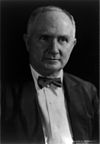
|
1980 | Northeastern corner of the junction of State Roads 156 and 250, one block west of the Ohio River in Patriot 38°50′18″N 84°49′36.6″W / 38.83833°N 84.826833°W |
Science, Medicine, and Inventions, Nature and Natural Disasters |

See also[]
- List of Indiana state historical markers
- National Register of Historic Places listings in Switzerland County, Indiana
References[]
- ^ "Indiana Historical Markers by County". State of Indiana. Retrieved 2012-03-15.
- ^ Birthplace John Shaw Billings, M.D. April 12, 1838 - March 11, 1913, Indiana Historical Bureau, n.d. Accessed 2012-03-14.
- ^ Dr. Elwood Mead (1858-1936), Indiana Historical Bureau, n.d. Accessed 2012-03-14.
External links[]
Municipalities and communities of Switzerland County, Indiana, United States | ||
|---|---|---|
| Towns | ||
| Townships | ||
| CDPs | ||
| Other unincorporated communities | ||
| ||
Categories:
- Switzerland County, Indiana
- Indiana state historical markers