List of Japanese map symbols
This is a list of symbols appearing on Japanese maps. These symbols are called chizukigou (地図記号) in the Japanese language.
| symbol | meaning | illustration | symbol | meaning | illustration |
|---|---|---|---|---|---|

|
Municipal building (city or ward level) | 
|

|
Municipal building (town or village level) | 
|

|
Court house or building | 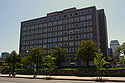
|

|
Fire station | 
|

|
Police station | 
|

|
Kōban | 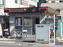
|

|
Public health center | 
|

|
Post office | 
|

|
Meteorological observatory | 
|

|
office |
|

|
Government office building | 
|

|
Elementary or junior highschool | 
|

|
High school | 
|

|
Junior college | 
|

|
Technical college | 
|

|
College or university | 
|

|
Museum | 
|

|
Library | 
|

|
Shinto shrine | 
|

|
Temple | 
|

|
Plant or factory | 
|

|
Hospital | 
|

|
Military base | 
|

|
Oil or gas well | 
|

|
Power station | 
|

|
Nursing home |
|

|
Castle | 
|

|
Chimney | 
|

|
Volcanic crater or Fumarole | 
|

|
Radio tower | 
|

|
TV tower | 
|

|
Place of historic, cultural, or scenic interest | 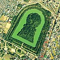
|

|
Monument | 
|
Wind turbine or farm | 
| |

|
Lighthouse | 
|

|
Hardwood forest or woods | 
|

|
Coniferous forest or woods | 
|

|
Palm trees | 
|

|
Bamboo grove | 
|

|
Dwarf pine forest or woods | 
|

|
Fields | 
|

|
Paddies | 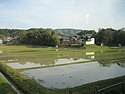
|

|
Orchard | 
|

|
Tea plantation | 
|

|
Mulberry orchard | 
|

|
Other plantation | 
|

|
Marsh or Grassland | 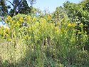
|

|
Graveyard or cemetery | 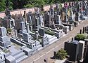
|

|
Mine | 
|

|
Pit head | 
|

|
Quarry | 
|

|
Onsen (hot spring) | 
|

|
Major port | 
|

|
Minor port | 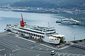
|

|
Fishing port | 
|

|
Ferry (car carrier) | 
|

|
Ferry | 
|

|
Benchmark | 
|

|
Fixed GPS survey point (Electronic triangulation point | 
|

|
Triangulation point | 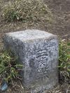
|
Partial list of symbols for the visually impaired[]
Official symbols according to the conventions of the Geographical Survey Institute of Japan appear with a circle below.
| Symbol | GSI | Meaning | Unicode | Description |
|---|---|---|---|---|
| ◬ | ○ | Base triangulation surveying point | U+25EC | Dot in upward-pointing triangle |
| ○ | Electronic triangulation point | Dot in upward-pointing triangle with flag | ||
| ⊡ | ○ | Benchmark | U+22A1 | Dot in square |
| ⛭ | ○ | Factory | U+26ED | Gear without hub |
| ⛯ | ○ | Lighthouse | U+26EF | Map symbol for lighthouse |
| ⛮ | ○ | Power station | U+26EE | Gear with handles |
| 文 | ○ | Elementary or junior high school | U+6587 | Kanji bun |
| ㉆ | ○ | High school | U+3246 | Kanji bun in a circle |
| ○ | University | Kanji bun with a smaller kanji 大 (for daigaku) in brackets on top | ||
| ○ | Technical college | Kanji bun with a smaller kanji 専 (for senmon gakkō) in brackets on top | ||
| 〶 | ○ | Post office | U+3036 | Down tack (T-shape) with overbar in circle |
| 〒 | × | Sub post office (not distribution centre) | U+3012 | Down tack (T-shape) with overbar |
| ⭙ | ○ | Police station | U+2B59 | Heavy circled saltire |
| ☓ | ○ | Koban (police box) | U+2613 | Diagonal cross (saltire) |
| ⊕ | ○ | Public health centre | U+2295 | Greek cross in circle |
| ⛨ | ○ | Hospital | Greek cross in shield | |
| ⭖ | ○ | Prefectural Office | U+26FB | Oval bullseye |
| ⭗ | ○ | City hall | U+2B57 | Heavy circle with circle inside |
| ◉ | ○ | Ward office | U+25C9 | Fisheye |
| ⭘ | ○ | Town hall | U+2B58 | Heavy circle |
| ⛩ | ○ | Shinto shrine | U+26E9 | Shinto shrine |
| 卍 | ○ | Buddhist temple | U+534D | Manji (Swastika) |
| ⛫ | ○ | Castle | U+26EB | Castle |
| ⛼ | ○ | Cemetery | U+26FC | Headstone graveyard symbol |
| ♨ | ○ | Onsen (hot springs) | U+2668 | Oval with three vertical wavy lines |
| ⛬ | ○ | Historical landmark | U+26EC | Historic site |
| ⛰ | ○ | Summit | U+26F0 | Mountain |
See also[]
- Key (map)
- List of Japanese typographic symbols – Wikipedia list article
- Geospatial Information Authority of Japan (GSI)
External links[]
| Wikimedia Commons has media related to Map symbols of Japan. |
- Japanese map symbols
- List of symbols (in Japanese) (Translate to English: Google, Bing)
- Children's list from the GSI (in Japanese) (Translate to English: Google, Bing) This is a very good reference, it has separate links for each symbol.
- Map Symbols (2002) from the GSI (in Japanese) (Translate to English: Google, Bing)
- Map symbols from the Its-mo online map (in Japanese) (Translate to English: Google, Bing)
Categories:
- Lists of symbols
- Maps of Japan
- Geography of Japan
- Cartography by country