List of World Heritage Sites in Kenya

Fort Jesus, Mombasa
Kenya Lake System in the Great Rift Valley
Lamu Old Town
Mount Kenya National Park/Natural Forest
Thimlich Ohinga Archaeological Site
The United Nations Educational, Scientific and Cultural Organization (UNESCO) World Heritage Sites are places of importance to cultural or natural heritage as described in the UNESCO World Heritage Convention, established in 1972.[1] Kenya accepted the convention, making its historical sites eligible for inclusion on the list. As of 2018, there are seven World Heritage Sites in Kenya.[2]
World Heritage Sites[]
- Site – named after the World Heritage Committee's official designation[3]
- Location – sorted by country, followed by the region at the regional or provincial level. In the case of multinational or multi-regional sites, the names are sorted alphabetically.
- Criteria – as defined by the World Heritage Committee[4]
- Area – in hectares and acres, excluding any buffer zones. A value of zero implies that no data has been published by UNESCO
- Year – during which the site was inscribed to the World Heritage List
- Description – brief information about the site, including reasons for qualifying as an endangered site, if applicable
| Name | Image | Location | Criteria | Area | Year | Description |
|---|---|---|---|---|---|---|
| Fort Jesus, Mombasa |  |
Mombasa, 4°03′46″S 39°40′46″E / 4.062778°S 39.679444°E |
Cultural: (i), (iv) |
161,485 (399,040) | 2011 | Fort Jesus is a Portuguese fort built from 1593 to 1596 on Mombasa Island to guard the old port of Mombasa, Kenya. The site's layout follows the Renaissance ideal that the human body is perfectly proportionate.[5] |
| Kenya Lake System in the Great Rift Valley | 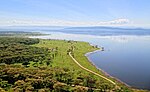 |
Rift Valley Province, 0°26′33″N 36°14′24″E / 0.442500°N 36.240000°E |
Natural: (viii), (x) |
161,485 (399,040) | 2011 | Located in the Great Rift Valley, Kenya, the site features three lakes: Lake Bogoria, Lake Nakuru and Lake Elementaita. A highly diverse population of birds, including thirteen threatened species, frequent the area.[6][7] |
| Lake Turkana National Parks |
 |
Lake Turkana, 3°03′05″N 36°30′13″E / 3.051306°N 36.503667°E |
Natural: (viii), (x) |
161,485 (399,040) | 1997 | Turkana, as Africa's largest saline lake, is an important area for the study of fauna and flora. It is a breeding ground for the Nile crocodile, hippopotamus and several venomous snakes.[8] The site was placed the List of World Heritage in Danger in 2018, primarily due to the potential impact of Ethiopia's Gilgel Gibe III Dam.[9] |
| Lamu Old Town |  |
Lamu, 2°16′05″S 40°54′07″E / 2.268°S 40.902°E |
Cultural: (ii), (iv), (vi) |
16 (40) | 2001 | The town is the oldest Swahili settlement, and is built in coral stone and mangrove timber. It features inner courtyards, verandas, and elaborate wooden doors.[10] |
| Mount Kenya National Park/Natural Forest |  |
Central Province and Eastern Province, 0°09′18″N 37°18′56″E / 0.155000°N 37.315556°E |
Natural: (vii), (ix) |
142,020 (350,900) | 1997 | The park surrounds the 5,199 m (17,057 ft) Mount Kenya and features twelve glaciers.[11] |
| Sacred Mijikenda Kaya Forests | 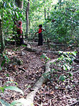 |
Coast Province, 3°55′55″S 39°35′46″E / 3.931944°S 39.596111°E |
Cultural: (iii), (v), (vi) |
1,538 (3,800) | 2008 | The site comprises eleven forests spread 200 km (120 mi) along the coast of Kenya. They hold the remains of villages built during the 16th century by the Mijikenda, and are now considered sacred sites.[12] |
| Thimlich Ohinga Archaeological Site |  |
Migori County, 0°58′23″S 34°15′30″E / 0.9731°S 34.2583°E |
Cultural: (iii), (iv), (v) |
21 (52) | 2018 | Dating back to the 16th century CE, the dry-stone walled settlement is the largest and best preserved traditional enclosures of its kind.[13] |

See also[]
External links[]
References[]
- ^ "The World Heritage Convention". UNESCO. Retrieved 21 September 2010.
- ^ "Kenya". UNESCO. Retrieved 11 August 2016.
- ^ United Nations Educational, Scientific and Cultural Organization (n.d.), World Heritage List, archived from the original on 1 November 2015, retrieved 5 November 2015.
- ^ "The Criteria for Selection". UNESCO. Retrieved 10 September 2011.
- ^ "Fort Jesus, Mombasa". UNESCO. Retrieved 11 July 2011.
- ^ "Kenya Lake System in the Great Rift Valley and Australia's Ningaloo Coast inscribed on UNESCO's World Heritage List". UNESCO. Retrieved 28 June 2011.
- ^ "Kenya Lake System in the Great Rift Valley". UNESCO. Retrieved 28 June 2011.
- ^ "Lake Turkana National Parks". UNESCO. Retrieved 28 May 2010.
- ^ "Lake Turkana National Parks (Kenya) inscribed on List of World Heritage in Danger". UNESCO. Retrieved 28 June 2018.
- ^ "Lamu Old Town". UNESCO. Retrieved 28 May 2010.
- ^ "Mount Kenya National Park/Natural Forest". UNESCO. Retrieved 28 May 2010.
- ^ "Sacred Mijikenda Kaya Forests". UNESCO. Retrieved 28 May 2010.
- ^ "Thimlich Ohinga Archaeological Site". UNESCO. Retrieved 1 August 2018.
| Locations | ||
|---|---|---|
| Related | ||
| History |
|  | |||
|---|---|---|---|---|---|
| Geography |
| ||||
| Politics | |||||
| Economy | |||||
| Society |
| ||||
Categories:
- World Heritage Sites in Kenya
- Lists of World Heritage Sites
- Kenya-related lists
- Lists of tourist attractions in Kenya