Wikipedia list article
This is a list of all the bridges and viaducts in the ceremonial county of Lincolnshire , England.
Bridges are listed under their current use or traffic. For example, Torksey Viaduct is listed under 'Highway' as it is now used by foot and cycle traffic, and not under 'Railway' as it used to be. However, if the bridge or viaduct has not been re-purposed yet it listed in the section of its original use.
Railway bridges [ ] Highway bridges [ ] A [ ]
Name
Crosses
Locality
Length (m)
Longest Span (m)
Date
Type
Grade
Notes
Image
Agnes Street Footbridge
River Witham
Grantham
Public footpath.
Aswardby Bridge
River Lymn
Aswardby
Aubourne Bridge 1
River Witham
Aubourn
Steel truss
Public bridleway. Deemed unsafe by Lincolnshire County Council with users advised to use the next bridge upstream.
Aubourne Bridge 2
River Witham
Aubourn
Concrete beam
Public footpath
Aubourne Fen Bridge
River Brant
Aubourn
Carries farm track. No public access.
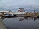
Aubourne Weir Footbridge
River Brant
Aubourn
Concrete beam
Public footpath. Part of the weir infrastructure. Also known as Mill Weir and Haddington Weir.
B [ ] C [ ]
Name
Crosses
Locality
Length (m)
Longest Span (m)
Date
Type
Grade
Notes
Image
Cadney Bridge
River Ancholme
Cadney
1882
Iron Arch
II
Carries farm track. Public Footpath. Designed by Alfred Atkinson.
Caistor Canal Lock 1 Bridge
Caistor Canal
South Kelsey
1795
Steel Arch
II
Public Footpath. Listing due to abutments not the span itself.
Carlton Lowfield Footbridge
River Brant
Carlton-le-Moorland
Steel Beam
Public footpath
Castlethorpe Bridge
River Ancholme
Castlethorpe
Iron Truss
Carries farm track. Public Footpath.
Castlethorpe Pipe Bridge
River Ancholme
Castlethorpe
Steel Truss
Carries pipeline.
Caythorpe Low Fields Bridge 1
River Brant
Caythorpe
Carries farm track. No public access.
Caythorpe Low Fields Bridge 2
River Brant
Caythorpe
Carries Gorse Hill Lane (minor road) between Brandon and Caythorpe .
Caythorpe Low Fields Bridge 2
River Brant
Brandon
Carries farm track. No public access.
Chain Bridge (new)
River Lymn
Wainfleet All Saints
Concrete Beam
Carries A52 .
Chain Bridge (old)
River Lymn
Wainfleet All Saints
Iron Beam
No public access. Carries farm track; it was a minor road before the New Chain Bridge (A52 Wainfleet Bypass) was built.
Childers North Drove
Coronation Channel (River Welland)
Spalding
Concrete Beam
Carries farm track. Public bridleway.
Childers South Drove
Coronation Channel (River Welland)
Spalding
Carries farm track. Public bridleway.
Church Bridge
River Witham
Bassingham
Concrete Beam
Public footpath
City Square Bridge
River Witham
Lincoln
Steel Arch
Footbridge connecting City Square and the Waterside Shopping Centre.
Claypole Bridge
River Witham
Claypole
Brick Arch
Carries Shire Lane (minor road) between Balderton and Claypole .
Claypole Footbridge
River Witham
Claypole
Steel Beam
Public footpath
Clough Bridge
River Lymn
Firsby
Carries minor road between Thorpe Fendykes and Firsby .
Clough Bridge
River Lymn
Wainfleet Clough
No public access. Carries farm track.
College Street Footbridge
River Witham
Grantham
Public footpath.
Corporation Bridge
Alexandra Dock
Grimsby
150
1925
Bascule
Designed by Charles Sacre . Replaced an earlier bridge from 1872.
County Bridge
Old River Ancholme
Brigg
1828
Stone Arch
II
Also known as Old Town Bridge.
Cow Bridge
Maud Foster Drain
Cowbridge, Boston
1811
Iron Arch
II
Public Footpath. Cast at the Butterley Works in Derbyshire.
Cowbit Road Bridge
Coronation Channel (River Welland)
Spalding
Concrete Beam
Carries Cowbit Road (B1172) between Spalding and Spalding Bypass .
Cowbridge Lock Footbridge
West Fen Drain
Cowbridge, Boston
Concrete Beam
Public Footpath. Part of sluice/lock infrastructure.
Crosskeys Bridge
River Nene
Sutton Bridge
1897
Swing
II*
Formerly carried a railway.
Crowle Bridge (New)
Stainforth and Keadby Canal and South Humberside Main Line
Crowle
Concrete Beam
Carries A161 . Replaced a swing bridge.
Crow's Bridge
River Lymn
Wainfleet Bank
1812
Brick Arch
II
Carries minor road between Wainfleet Bank and Wainfleet All Saints . Designed by John Rennie .
D [ ]
Name
Crosses
Locality
Length (m)
Longest Span (m)
Date
Type
Grade
Notes
Image
Dale Bridge
The Dale
West Rasen
Concrete Beam
Carries A631 .
Dixon Street Bridge
River Witham
Lincoln
Concrete Arch
Carries Dixon Street (B1360).
Doddington Bridge
River Witham
Dry Doddington
Concrete Beam
Carries Doddington Lane (minor road) between Dry Doddington and the A1 .
Duckpool Bridge
Catchwater Drain
Stixwould
Concrete Arch
Carries minor road (C603) between Stixwould and Bucknall /Horsington .
Dudley Road Footbridge
River Witham
Grantham
Steel Arch
Public footpath.
Dunham Bridge
River Trent
Dunham-on-Trent
1832/1979
Steel Beam
Current bridge rebuilt on original piers.
E [ ]
Name
Crosses
Locality
Length (m)
Longest Span (m)
Date
Type
Grade
Notes
Image
East Drain Bridge
East Drain
Owersby
Brick Arch
Public Footpath.
F [ ]
Name
Crosses
Locality
Length (m)
Longest Span (m)
Date
Type
Grade
Notes
Image
Ferriby Sluice Bridge 1
New River Ancholme
Ferriby Sluice
Lift Bridge
Scheduled Ancient Monument
Carries A1077 . Part of the sluice infrastructure. Ferriby Sluice is a Scheduled Ancient Monument.
Ferriby Sluice Bridge 2
New River Ancholme
Ferriby Sluice
Concrete Beam
Scheduled Ancient Monument
Carries A1077 . Part of the sluice infrastructure. Ferriby Sluice is a Scheduled Ancient Monument.
Ferriby Sluice Bridge 3
Old River Ancholme
Ferriby Sluice
Stone Arch
Scheduled Ancient Monument
Carries Public Footpath. Ferriby Sluice is a Scheduled Ancient Monument.
Ferriby Sluice Conveyor Bridge 1
B1204 Road
Ferriby Sluice
Steel Truss
Carries clay and cement and clay between the quarry and cement works.
Ferriby Sluice Conveyor Bridge 2
River Ancholme
Ferriby Sluice
Steel Truss
Carries clay and cement and clay between the quarry and cement works.
Ferriby Sluice Footbridge
Old River Ancholme
Ferriby Sluice
Steel Truss
Ferry Farm Pipe Bridge
Foss Dyke , Lincoln to Gainsborough Line (rail)
Skellingthorpe
Steel Truss
Firth Road Footbridge
River Witham
Lincoln
Concrete Arch
Public Footpath. Immediately parallel to Firth Road Bridge.
Firth Road Bridge
River Witham
Lincoln
Iron Box Girder
Carries Firth Road (minor road).
Five Mile Bridge
River Witham
Fiskerton
Steel Truss
Footbridge connecting the Water Rail Way (south bank) to the north bank and Fiskerton . So named since it is five miles east of Lincoln .
Fosdyke Bridge
River Welland
Fosdyke
Steel Beam
Carries A17 . Lowest crossing of the River Welland . Location has been an important river crossing for centuries and reputedly the location where King John lost his treasure.
Fulbeck Low Fields Bridge
River Brant
Stragglethorpe
Carries Brant Road (minor road) between Fulbeck and Stragglethorpe .
Fulbeck Low Fields footbridge
River Brant
Stragglethorpe
No public access.
G [ ]
Name
Crosses
Locality
Length (m)
Longest Span (m)
Date
Type
Grade
Notes
Image
Gaunt Street Footbridge
River Witham
Lincoln
Iron Truss
Disused?
Gipsey Bridge
Castle Dyke
Gipsey Bridge
Brick Arch
Carries B1184
Glanford Bridge
Old River Ancholme
Brigg
Steel Beam
Carries A18 .
Godnow Bride
Stainforth and Keadby Canal
Crowle
Swing Bridge
Grand Sluice
River Witham
Boston
1766/1883
II
Sluice designed by John Grundy and Langley Edwards. The road bridge is part of the sluice infrastructure and was added in the early 20th century.
Grantham Bridge 1
River Witham
Grantham
Carries Belton Lane (minor road) through Grantham.
Grantham Footbridge 1
River Witham
Grantham
Steel Arch
Public footpath.
Great Ponton Bridge
River Witham
Great Ponton
Carries Dallygate Lane (minor road) between Great Ponton and Ermine Street (B6403 ).
Great Ponton Mill Footbridge
River Witham
Great Ponton
Part of watermill infrastructure. No public access.
H [ ]
Name
Crosses
Locality
Length (m)
Longest Span (m)
Date
Type
Grade
Notes
Image
Haddington Bridge
River Witham
Haddington
Concrete beam
Carries Bridge Road (minor road) between Haddington and Aubourn .
Haltham Lock Footbridge
River Bain
Haltham
Concrete Beam
Public Footpath. Part of the weir (formally lock) infrastructure.
Haltoft End Bridge
Hobhole Drain
Haltoft End
Carries A52 .
Halton Bridge
River Lymn
Halton Holegate
Carries B1195.
Hambleton Bridge
River Witham
Syston
Concrete Beam
Carries farm track. Public footpath.
Harlem Hill Lock Footbridge 1
River Ancholme
Bishop Norton
Steel Arch
Bridge also part of the lock infrastructure.
Harlem Hill Lock Footbridge 2
River Ancholme
Bishop Norton
Steel Beam
Part of weir (former lock) infrastructure.
Harrowby Mill Bridge
River Witham
Manthorpe
Concrete Beam
Part of weir (former mill) infrastructure.
Haven Bridge
River Witham
Boston
1966
Concrete Arch
Carries the A16 John Adams Way
Hibaldstow Bridge
River Ancholme
near Hibaldstow
1889
Iron Arch
II
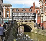
High Bridge
River Witham
Lincoln
1160
Stone Arch
I
Oldest bridge in Britain with buildings on it.
Holbeach Road Bridge
Coronation Channel (River Welland)
Spalding
Concrete Beam
Carries Holbeach Road (A151 ) through Spalding .
Holme Barn Farm Bridge
River Witham
Claypole
Carries farm track. No public access.
Horkstow Bridge
New River Ancholme
Horkstow
42.6
1836
Suspension
II*
Designed by Sir John Rennie .
Hospital Bridge
Maud Foster Drain
Boston
1811
Iron Arch
II
Public Footpath. Cast at the Butterley Works in Derbyshire.
Hougham Footbridge 1
River Witham
Hougham
No public access
Hougham Footbridge 2
River Witham (former course)
Hougham
Public footpath
Hougham Weir Footbridge
River Witham
Hougham
Public footpath. Part of the weir infrastructure.
Hubbert's Bridge
South Forty Foot Drain
Hubberts Bridge
17
17
1888
Brick Arch
Carries B1192 . Designed by John Kingston, the County Surveyor for the Parts of Holland .
Humber Bridge
The Humber
Barton-upon-Humber
2,220
1,410
1981
Suspension
Longest single-span in the UK and formerly the World
Hykeham Bridge
River Witham
North Hykeham
Concrete Beam
Carries Meadow Lane (minor road) between North Hykeham and Waddington .
Hykeham Footbridge
River Witham
North Hykeham
Concrete Beam
Public Footpath.
I [ ]
Name
Crosses
Locality
Length (m)
Longest Span (m)
Date
Type
Grade
Notes
Image
Ings Bridge
Hobhole Drain
Boston Long Hedges
Brick arch
K [ ] L [ ]
Name
Crosses
Locality
Length (m)
Longest Span (m)
Date
Type
Grade
Notes
Image
Langrick Bridge
River Witham
Langrick
1909
Steel Truss
Carries B1192
Leadenham Mill Bridge
River Brant
Brant Broughton
Carries A17
Lincoln University Footbridge 1
River Witham
Lincoln
Concrete Arch
Lincoln University Footbridge 2
River Witham
Lincoln
Steel Truss Arch
Disused
Little Ponton Bridge
River Witham
Little Ponton
1922
Concrete Beam
Carries Whalebone Lane (minor road) between Little Ponton and Woodnock .
Long Bennington Bridge 1
River Witham
Long Bennington
Carries Westborough Lane (minor road) between Long Bennington and Westborough .
Long Bennington Bridge 2
River Witham
Long Bennington
Concrete Beam
Carries farm track. Public footpath. Carries Viking Way .
Long Bennington Footbridge
River Witham
Long Bennington
Carries unofficial public footpath.
Low Road Bridge
Coronation Channel (River Welland)
Spalding
Carries Low Road (minor road) between Spalding and Spalding Bypass .
Lush's Bridge
Mill Drain
Frithville
Concrete Beam
Carries B1183.
M [ ]
Name
Crosses
Locality
Length (m)
Longest Span (m)
Date
Type
Grade
Notes
Image
M180 Brigg Bridge
River Ancholme
Brigg
Concrete Beam
Carries M180
M180 Trent Viaduct
River Trent
West Butterwick
271
1979
Concrete Arch
Carries M180
Magpie Bridge
River Witham
Lincoln
Stone Arch
Carrie Melville Street (A15 ). Also known as Thorne Bridge.
Malcolm Arms Bridge
Newham Drain
Anton's Gowt
Brick Arch
Carries minor road.
Manthorpe Bridge
River Witham
Manthorpe
No public access.
Manthorpe Footbridge 1
River Witham (former course)
Manthorpe
No public access.
Manthorpe Footbridge 2
River Witham (former course)
Manthorpe
No public access.
Manthorpe Mill Bridge 1
River Witham
Manthorpe
No public access.
Manthorpe Mill Bridge 2
River Witham (mill stream course)
Manthorpe
No public access.
Manthorpe Mill Bridge 3
River Witham
Manthorpe
No public access.
Market Bridge
River Bain
Great Sturton
Concrete Beam
On the site of the crossing of the Roman Lincoln to Skegness Road of the River Bain.
Marlborough Bridge
River Brant
Marlborough
Carries farm track. No public access.
Marsh Road Sluice Bridge
Coronation Channel (River Welland)
Spalding
Carries March Road (minor road) between Spalding and Spalding Marsh.
Marston Mill Bridge
River Witham
Marston
Carries farm track. No public access.
Mason's Bridge
River Bain
Coningsby
Steel Beam
Public Footpath
Maud Foster Footbridge
Maud Foster Drain
Boston
Concrete Beam
Public Footpath
Melville Street Footbridge
Melville Street (A15 )
Lincoln
Concrete Arch
Public Footpath
Mickling Plantation Bridge
River Witham
Barkston
Steel Truss
Carries farm track. Public footpath. Carries Viking Way .
Mill Bridge
River Lymn
Great Steeping
Carries minor road between Halton Fenside and Great Steeping .
Mill Farm Bridge
River Witham
Claypole
Brick Arch
Carries farm track. Public footpath.
Mill Farm Bridge
River Witham
Marston
Carries farm track. No public access.
N [ ] O [ ]
Name
Crosses
Locality
Length (m)
Longest Span (m)
Date
Type
Grade
Notes
Image
Odder Pipe Bridge
Foss Dyke , Lincoln to Gainsborough Line (rail)
Odder
Steel Truss
Old Beckingham Bridge
River Witham
Beckingham
Concrete Beam
Public footpath
Old North Bridge
River Witham
Marston
Brick Arch
No longer used. Replaced by North Bridge.
Old Tollgate Bridge
Old River Ancholme
South Kelsey
18th century
Brick Arch
II
P [ ]
Name
Crosses
Locality
Length (m)
Longest Span (m)
Date
Type
Grade
Notes
Image
Packhorse Bridge
River Rase
West Rasen
1310
Stone Arch
II* and Scheduled Ancient Monument
Has 15th-century alterations. Built by Bishop of Lincoln John Dalderby . Also known as Bishop's Bridge, but not to be confused with Bishop's Bridge two miles downstream.
Packhorse Bridge
Unnamed Stream
Utterby
14th century
Stone Arch
II* and Scheduled Ancient Monument
Paper Mill Farm Bridge
River Witham
Spittlegate
Carries farm track. No public access.
Paper Mill Farm Footbridge
River Witham
Spittlegate
Part of weir infrastructure. No public access.
Partney Bridge
River Lymn
Partney
Carries A16 .
Paul's Bridge
Frith Bank Drain
Cowbridge, Boston
Concrete Beam
Carries B1183.
Pelham Bridge
Peterborough to Lincoln Line (rail) and local roads
Lincoln
300
1958
Concrete Arch
Carries A15 Dual-Carriageway
Pilford Bridge
River Ancholme
Toft next Newton
Concrete Beam
Carries Highgate Lane (minor road) between Toft next Newton and Normanby-by-Spital .
Poucher's Bridge
Catchwater Drain
Bucknall
Concrete Beam
No public access. Carries farm track.
Pyewipe Inn Bridge
Foss Dyke , Lincoln to Gainsborough Line (rail).
Lincoln
Concrete Beam
Carries Lincoln Bypass (A46 ) and Sustrans route 64 .
R [ ]
Name
Crosses
Locality
Length (m)
Longest Span (m)
Date
Type
Grade
Notes
Image
Raithby Bridge
Unknown Stream
Raithby
Carries minor road between Hagworthingham and Raithby .
Rawson's Bridge
Maud Foster Drain
Boston
1805
Brick Arch
II
Possibly designed by John Rennie
Redcross Street Footbridge
River Witham
Grantham
Public footpath.
Red Mill Bridge
River Bain
Kirkby on Bain
Brick Arch
Carries Rime's Lane.
Richardson's Bridge
West Fen Drain
Cowbridge, Boston
Brick Arch
Carries B1183. Formerly known as Kitchen's Bridge.
Riverside Drive Apartments Footbridge
River Witham
Lincoln
Concrete Beam
Public Footpath.
Ropewalk Bridge
River Witham
Lincoln
Brick Arch
Ropewalk Bridge 1
River Witham
Lincoln
Concrete Beam
Public Footpath. Immediately north of Ropewalk Bridge.
Ropewalk Bridge 2
River Witham
Lincoln
Steel Truss
Public Footpath. Immediately south of Ropewalk Bridge.
Russell Street Bridge
River Witham
Bracebridge , Lincoln
1924
Iron Beam
Public footpath. Originally located elsewhere, but moved into current location in 1924.
S [ ]
Name
Crosses
Locality
Length (m)
Longest Span (m)
Date
Type
Grade
Notes
Image
Saltersford Bridge
River Witham
Saltersford
No public access.
Saltersford Footbridge 1
River Witham
Saltersford
No public access.
Saltersford Footbridge 2
River Witham
Saltersford
No public access.
Saltersford Footbridge 3
River Witham
Saltersford
No public access.
Sausthorpe Bridge
River Lymn
Sausthorpe
Carries minor road between Raithby and Sausthorpe .
Saxby Bridge
River Ancholme
Saxby All Saints
19th century
Iron Arch
II
Saxilby A57 rail bridge
Lincoln to Gainsborough Line (rail)
Saxilby
Concrete Beam
Carries A57 .
Saxilby Bridge
Foss Dyke
Saxilby
Steel Beam
Carries A57 .
Saxilby Footbridge 1
Foss Dyke
Saxilby
Iron Truss
Public footpath. At Saxilby Wharf. On site of previous swing bridge.
Saxilby Footbridge 2
Foss Dyke
Saxilby
Steel Truss
Public footpath. Parallel to rail bridge.
Saxilby Pipe Bridge 1
Foss Dyke
Saxilby
Steel Truss
Pipe bridge
Saxilby Pipe Bridge 2
Foss Dyke
Saxilby
Tubular Steel Pipe
Pipe bridge
Scawby Bridge
New River Ancholme
Brigg
1827
Stone Arch
II
Carries A18 . Designed by Sir John Rennie .
Scotwater Bridge
River Witham
Norton Disney
1850
Brick Arch
Sherman's Wath Bridge
River Bain
West Ashby
Carries Sherman's Wath (road)
Short Ferry Bridge
Barlings Eau
Short Ferry
Steel Arch
Skerth Bridge
Skerth Drain
Swineshead
Carries A1121 .
Skinnand Bridge
River Brant
Skinnand
Carries minor road between Bassingham and Navenby .
Slate Mill Bridge
River Witham
Grantham
Concrete Beam
Public footpath.
Spalding Bridge 1
River Welland
Spalding
Concrete Beam
Carries A151 through Spalding . Part of roundabout twin bridge.
Spalding Bridge 2
River Welland
Spalding
Concrete Beam
Carries A151 through Spalding . Part of roundabout twin bridge.
Spalding Bypass Bridge 1
River Welland
Spalding
Steel Arch
Carries Spalding Bypass (A16 ).
Spalding Bypass Bridge 2
River Welland
Spalding
Steel Arch
Carries Spalding Bypass (A1175 ).
Spalding Drove Bridge
Coronation Channel (River Welland)
Spalding
Carries Spalding Drover (minor road) between Spalding and Spalding Bypass .
Spalding Road Bridge
South Forty Foot Drain
Boston
Steel Beam
Carries A16 . Replaced a railway bridge in the same location.
St. Botolph's Footbridge
River Witham
Boston
2014
Steel Arch
Replaced a previous footbridge.
St. Catherine's Road Bridge
River Witham
Grantham
Carries St Catherine's Road (minor road) through Grantham .
Stapleford Church Bridge
River Witham
Stapleford
Concrete Beam
Stapleford Bridge
River Witham
Stapleford
Carries Clay Lane (minor road) between Stapleford and Brant Broughton .
Station Street Bridge
River Witham
Lincoln
Carries Station Street (minor road).
Stockwith Mill Bridge
River Lymn
Harrington
Brick Arch
Carries Harrington Road (minor road) between Hagworthingham and Harrington
Stone Bridge
Stone Bride Drain
Frithville
Concrete Beam
Stonebridge Road Bridge
River Witham
Grantham
Concrete Beam
Carries minor road (Stonebridge Road) through Grantham .
Stragglethorpe Bridge 1
River Brant
Stragglethorpe
Public footpath
Stragglethorpe Bridge 2
Sand Beck
Stragglethorpe
Public footpath
Stragglethorpe Bridge 2
Sand Beck
Stragglethorpe
Carries farm track. No public access.
Stragglethorpe Bridge 2
Sand Beck
Stragglethorpe
Carries farm track. No public access.
Swineshead Bridge
South Forty Foot Drain
Swineshead Bridge
Concrete Beam
Carries A17 .
T [ ] W [ ]
Name
Crosses
Locality
Length (m)
Longest Span (m)
Date
Type
Grade
Notes
Image
Warth's Bridge
River Lymn
Thorpe Culvert
Carries minor road between Thorpe Fendykes and Thorpe Culvert .
Westborough Footbridge 1
River Witham
Westborough
Steel Beam
Public footpath. Carries Viking Way .
Westborough Footbridge 2
River Witham
Westborough
Concrete Beam
Public bridleway
White House Bridge
River Lymn
Wainfleet
Brick Arch
Carries a minor road between Wainfleet All Saints and the coast .
Wigford Way
River Witham
Lincoln
19
19
1972
Concrete Beam
Carries A57 Wigford Way Dual-Carriageway
Willson's Gorse Bridge
River Brant
Stragglethorpe
Carries farm track. No public access.
Wisemans Bridge
South Soak Drain
Crowle
1989
Steel Beam
Pedestrian Bridge built by Bullivant Engineering for Keadby Canal JAC.
Witham Farm Bridge
River Witham
Claypole
Carries farm track. No public access.
Witham Washland Control Site Bridge
River Witham
South Hykeham
1980s
Concrete Arch
Carries farm track. No public access. Part of flood defence infrastructure.
Wyberton High Bridge
South Forty Foot Drain
Boston
22.5
22.5
1930
Concrete Arch
Carries A52. Built for Holland County Council.
Other bridges [ ]
Name
Crosses
Locality
Length (m)
Longest Span (m)
Date
Type
Grade
Notes
Image
Cowbridge Aqueduct
Cow Bridge Drain
Cowbridge, Boston
Carries Stonebridge Drain.
See also [ ]
List of bridges in Europe
Sovereign states States with limited Dependencies and
Faroe Islands Isle of Man