Dry Doddington
| Dry Doddington | |
|---|---|
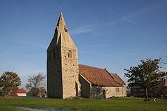 Church of St James, Dry Doddington | |
 Dry Doddington Location within Lincolnshire | |
| OS grid reference | SK850466 |
| • London | 105 mi (169 km) S |
| Civil parish | |
| District | |
| Shire county | |
| Region | |
| Country | England |
| Sovereign state | United Kingdom |
| Post town | Newark |
| Postcode district | NG23 |
| Police | Lincolnshire |
| Fire | Lincolnshire |
| Ambulance | East Midlands |
| UK Parliament | |

Dry Doddington is a small village in the north-west of the South Kesteven district of Lincolnshire, England within the civil parish of Westborough and Dry Doddington. It is situated approximately 5 miles (8 km) south-east from Newark, approximately 8 miles (13 km) north-west from Grantham, and just over 1 mile (2 km) to the east from the A1 road.
History[]
Dry Doddington means the "dry estate of a man called Dodda". There was a deserted medieval village called 'Stocking' or 'Stockyng' associated with Dry Doddington in the early 14th century; its precise location is unknown.[1]
Dry Doddington CE School was built as a National School in 1872, but was closed between 1926 and 1929, after which it re-opened as a primary school. It closed for the last time in 1961.[2]
Today, the village forms part of the civil parish of Westborough and Dry Doddington, which had a population of 335 in 2001. Before 1931 Dry Doddington was a separate parish.[3]
The village public house is The Wheatsheaf Inn on Main Street.[4]
Geography[]
The village, on a small hill called Lincoln Hill, is surrounded by the River Witham to the west and south. The village of Claypole is to the north and Westborough and Long Bennington 1 mile (1.6 km) to the south. The East Coast Main Line passes 1 mile to the north-east.
The Church of St James[]
The parish church, dedicated to St James, has a west-ward leaning tower. It is a Grade II* listed building dating from the 12th century, with an early 14th-century tower. It was restored in 1876.[5][6]
Recent restoration work, funded by the Heritage Lottery Fund, has brought the 14th century tower back to its former glory. The tower boasts an impressive tilt of 4.8[7] or 5.1[8] degrees, leaning more than the Leaning Tower of Pisa in Italy which is now tilted at 3.97 degrees.
The church contains a memorial to a No. 49 Squadron RAF Avro Lancaster that crashed near the village on 26 November 1944. The aircraft, called 'O-Oboe', was piloted by F/O Le Marquand (PB432). It had only been in the air for a few minutes before it crashed, laden with bombs and fuel. Whilst five members of the crew survived, Norman Langley, the wireless operator and air gunner, and Edward Blake, the mid-upper gunner, were killed.[9]
References[]
- ^ "Stocking deserted medieval village". Lincs to the Past. Lincolnshire Archives. Retrieved 2 July 2011.
- ^ "Dry Doddington CE School". Lincs to the Past. Lincolnshire Archives. Retrieved 2 July 2011.
- ^ "Dry Doddington". Vision of Britain. University of Portsmouth. Archived from the original on 25 December 2012. Retrieved 2 July 2011.
- ^ "The Wheatsheaf", geograph.org.uk. Retrieved 22 July 2011
- ^ Historic England. "St James, Dry Doddington (323937)". Research records (formerly PastScape). Retrieved 2 July 2011.
- ^ Historic England. "St James Dry Doddington (1253449)". National Heritage List for England. Retrieved 5 April 2015.
- ^ "Going for the tourist angle." Newark Advertiser. 11 July 2013
- ^ "More Tilt than Pisa Tower Could Boost Dry Doddington Visits." BBC News Services. BBC, 12 October 2015. Web. <https://www.bbc.com/news/uk-england-lincolnshire-34504739>.
- ^ "Dry Doddington Memorial". Bomber History. Malcolm Brooke/49 Squadron Association. Archived from the original on 28 September 2011. Retrieved 2 July 2011.
External links[]
 Media related to Dry Doddington at Wikimedia Commons
- Westborough and Dry Doddington Parish Council
- Crash memorial
- Bomber History
England Portal | |
| Unitary authorities | |
| Boroughs or districts | |
| Major settlements |
|
| Topics | |
- South Kesteven District
- Villages in Lincolnshire