List of castles and fortresses in Switzerland

This list includes castles and fortresses in Switzerland.
Entries list the name and location of the castle, fortress or ruins in each Canton in Switzerland.
Aargau[]

Schlossli
Aarburg
Altenburg
Alt-Wartburg
Auenstein
Bernau
Biberstein
Bottstein
Brestenberg
Brunegg
Freudenau
Habsburg
Hallwyl
Hilfikon
Horben
Alt-Homberg
Iberg
Kasteln
Klingnau
Landvogteischloss
Laufenburg
Lenzburg
Liebegg
Rued
Schafisheim
Schenkenberg
Schwarzer
Schwarzwasserstelz
Stein
Tegerfelden
Alt-Thierstein
Trostburg
Urgiz
Waldhausen
Wildenstein
Wildegg
class=notpageimage|
Castles in Aargau| Name | Image | Location | Type | Date | Notes |
|---|---|---|---|---|---|
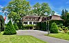
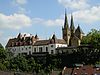
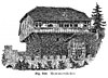
| Aarburg Castle |  |
Aarburg 47°19′17.91″N 7°54′3.36″E / 47.3216417°N 7.9009333°E |
12th century, 1659–1673 | Houses Kantonale Jugendheim, for juvenile offenders | |
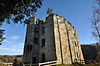
| Altenburg Castle |  |
Brugg 47°28′55.24″N 8°11′39.62″E / 47.4820111°N 8.1943389°E |
Roman fort 370 Medieval castle 10th century |
Includes part of a Roman wall. Today a youth hostel | |
| Auenstein Castle |  |
Auenstein 47°24′55.48″N 8°8′23.17″E / 47.4154111°N 8.1397694°E |
13th century | Privately owned, not open to the public | |
| Bernau Castle |  |
Leibstadt 47°35′43″N 8°10′20″E / 47.59528°N 8.17222°E |
Ruined hill castle | 1157 | Ruined castle, destroyed in 1844 |
| Biberstein Castle |  |
Biberstein 47°24′47.60″N 8°5′0.70″E / 47.4132222°N 8.0835278°E |
around 1280 | Group home for adults | |
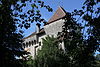
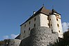
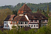
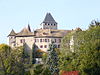
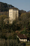
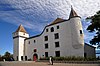
| Böttstein Castle |  |
Böttstein 47°33′14.80″N 8°13′27.23″E / 47.5541111°N 8.2242306°E |
1100–1200 | Became headquarters of Beznau Nuclear Power Plant construction in 1965, converted to restaurant and hotel in 1974 | |
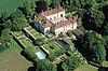
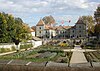
| Brestenberg Castle |  |
Seengen 47°19′11.50″N 8°12′29.52″E / 47.3198611°N 8.2082000°E |
1625 | Museum | |
| Brunegg Castle |  |
Brunegg 47°25′19.78″N 8°12′52.16″E / 47.4221611°N 8.2144889°E |
13th century | ||
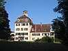
| Freudenau Castle |  |
Untersiggenthal 47°30′44.5″N 8°14′2.5″E / 47.512361°N 8.234028°E |
Ruined lowland castle | around 1240 | Ruined castle |
| Habsburg Castle |  |
Habsburg 47°27′45.86″N 8°10′51.74″E / 47.4627389°N 8.1810389°E |
hill castle, summit location | Around 1020/30 to 1300 | Original home of the Habsburg family |
| Hallwyl Castle |  |
Seengen 47°19′23.5″N 8°11′39″E / 47.323194°N 8.19417°E |
water castle | 1265 | Part of Cantonal Museum |
| Hilfikon Castle | 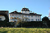 |
Hilfikon 47°19′51″N 8°14′49″E / 47.33071°N 8.24692°E |
1290 | ||
| Alt Homberg Castle | Wittnau, Aargau 47°29′28″N 7°58′23″E / 47.491056°N 7.972999°E |
Ruined castle | around 1100 | Only fragments still visible | |
| Horben Castle | 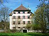 |
Beinwil (Freiamt) 47°13′12.29″N 8°19′36.34″E / 47.2200806°N 8.3267611°E |
1700 | Privately owned | |
| Iberg Castle |  |
Iberg, Riniken 47°30′20.01″N 8°11′12.64″E / 47.5055583°N 8.1868444°E |
Ruined hill castle | 11th century | |
| Kasteln Castle |  |
Oberflachs 47°26′32.57″N 8°07′08.87″E / 47.4423806°N 8.1191306°E |
1238 | School for special needs students | |
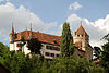
| Klingnau Castle |  |
Klingnau 47°34′51.75″N 8°14′54.29″E / 47.5810417°N 8.2484139°E |
Castle | After 1239 | Residence of Bishop of Constance in 14th century. Today privately owned |
| Baden | |||||
| Laufenburg | |||||
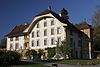
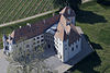
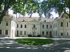
| Lenzburg Castle | Lenzburg 47°23′15″N 8°11′08″E / 47.38738°N 8.18548°E |
hill castle | before 1036 | Originally home of the Counts of Lenzburg. Now part of the Cantonal Museum | |
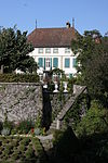
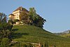
| Liebegg Castle | 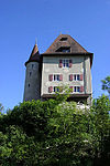 |
Gränichen 47°20′11″N 8°07′04″E / 47.33630°N 8.11770°E |
hill castle | 1150-1200 | Cantonal Agricultural School beginning 1958. Between 1983 and 1998 home to the Cantonal Teacher's College |
| Schlossrued | |||||
| Schafisheim | |||||
| Fisibach | |||||
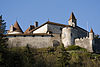
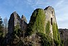
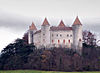
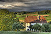
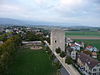
| Schenkenberg Castle | 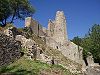 |
Thalheim 47°26′31.16″N 8°06′2.66″E / 47.4419889°N 8.1007389°E |
Ruined hill castle | 1243 | Originally residence of ministeriales family. |
| Aarau | |||||
| Schöftland | |||||
| Brugg | |||||
| Stein Castle | Baden 47°28′23.38″N 8°18′19.62″E / 47.4731611°N 8.3054500°E |
hill castle | Before 1000, 1658–1670 | Destroyed in 1415 by the Swiss Confederation. Rebuilt in 1658-70, demolished in 1712 | |
| Gipf-Oberfrick | Ruined Castle | ||||
| Tegerfelden | |||||
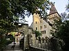
| Trostburg Castle | 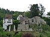 |
Teufenthal 47°19′51.38″N 8°07′06.49″E / 47.3309389°N 8.1184694°E |
hill castle | 1200 | 19th century music box factory, partially repaired in 1999 |
| Densbüren | Ruined Castle | ||||
| Fisibach | |||||
| Oftringen | |||||
| Veltheim | |||||
| Wildegg Castle | Möriken-Wildegg | 1242 |
Appenzell Ausserrhoden[]
class=notpageimage|
Castles in Appenzell Ausserrhoden| Name | Image | Location | Type | Date | Notes |
|---|---|---|---|---|---|
| Rosenberg |  |
Herisau-Burghalden 47°23′47″N 9°16′55″E / 47.3964°N 9.2819°E |
Ruined hill castle | about 1150 | Ruined castle |
| Rosenburg/Ramsenberg |  |
Herisau 47°23′18″N 9°15′16″E / 47.3883°N 9.2544°E |
Ruined hill castle | about 1150 | Ruined castle |
| Herisau 47°23′07″N 9°19′28″E / 47.38516°N 9.32438°E |
Appenzell Innerrhoden[]

Appenzell
Clanx
class=notpageimage|
Castles in Appenzell Innerrhoden| Name | Image | Location | Type | Date | Notes |
|---|---|---|---|---|---|
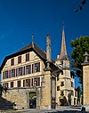
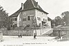
| Appenzell Castle | 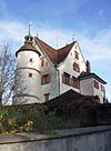 |
Appenzell 47°19′48″N 9°24′35″E / 47.329947°N 9.409615°E |
Manor house | 1563 | Original owner Antoni Löw executed 1584. 1584-1682 used as Franciscan monastery. Today known as "Doctor's House" and privately owned. |
| Clanx Castle | Appenzell 47°20′50″N 9°24′40″E / 47.347312°N 9.411171°E |
Ruined castle | 1219 | Burned during Appenzell Wars. Ruins rediscovered in 1885. | |
| Oberegg 47°24′01″N 9°32′40″E / 47.40023°N 9.54442°E |
Ruins |
Basel-Land[]

Aesch
Angenstein
Altenberg
Burg
Birseck
Bischofstein
Bottmingen
Ebenrain
Farnsburg
Frohberg
Neu-Homburg
Pfeffingen
Reichenstein
Alt-Schauenburg
Neu-Schauenburg
Sissacherfluh
St. Arbogast
Wildenstein
class=notpageimage|
Castles in Basel-Land| Name | Image | Location | Type | Date | Notes |
|---|---|---|---|---|---|
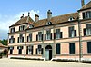
| Aesch Castle | 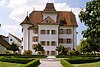 |
Aesch 47°27′12″N 07°35′39″E / 47.45333°N 7.59417°E |
Manor house | 1606 | Now municipal administration building |
| Altenberg Castle |  |
Füllinsdorf 47°30′34.31″N 7°44′23.84″E / 47.5095306°N 7.7399556°E |
Ruins | about 1000 | |
| Angenstein Castle |  |
Duggingen 47°27′47.89″N 7°36′17.3″E / 47.4633028°N 7.604806°E |
Partly ruined hill castle | Mid 13th century | |
| Duggingen | Ruins | ||||
| Burg Castle (Burg im Leimental) |  |
Burg im Leimental 47°27′25″N 7°26′26″E / 47.456807°N 7.440613°E |
hill castle | about 1250 | |
| Burg im Leimental | Ruins | ||||
| Binningen | |||||
| Arlesheim | |||||
| Vordere Birseck Castle |  |
Arlesheim 47°29′31″N 7°37′43″E / 47.49194°N 7.62861°E |
hill castle | 1243/44 | Partially ruined castle, outer castle well preserved |
| Arlesheim | |||||
| Bischofstein Castle |  |
Sissach 47°28′28.72″N 7°49′37.32″E / 47.4746444°N 7.8270333°E |
Ruined hill castle | Mid 13th century | Extensive, preserved walls |
| Bottmingen Castle |  |
Bottmingen 47°31′25″N 7°34′13″E / 47.523701°N 7.570191°E |
water castle | 13th century | |
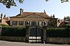
| Ebenrain Castle | 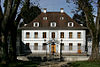 |
Sissach 47°27′51″N 7°48′18″E / 47.464228°N 7.80496°E |
Manor house | 1774-76 | |
| Pfeffingen | |||||
| Farnsburg Castle |  |
Ormalingen 47°29′35.5″N 7°52′14.05″E / 47.493194°N 7.8705694°E |
Ruined hill castle | Between 1319 and 1342 | Ruined castle |
| Frohberg Castle |  |
Aesch 47°28′4.25″N 07°33′43.1″E / 47.4678472°N 7.561972°E |
Ruined hill castle | Late 13th century | Ruined castle |
| Ettingen | Ruined castle | ||||
| Bubendorf | Ruined castle | ||||
| Binningen | |||||
| Neu-Homburg Castle |  |
Läufelfingen 47°24′10.5″N 7°51′18″E / 47.402917°N 7.85500°E |
hill castle | 1240 | Ruined castle residence of counts. |
| Pratteln | Ruined castle | ||||
| Münchenstein Castle | Münchenstein 47°30′45.22″N 07°37′17.1″E / 47.5125611°N 7.621417°E |
Ruined hill castle | likely 1260 to 1275 | Ruined castle residence of Ministerialis. | |
| Pfeffingen | Ruined castle | ||||
| Wenslingen | Ruined castle | ||||
| Pfeffingen Castle |  |
Pfeffingen 47°27′12″N 7°35′29″E / 47.45333°N 7.59139°E |
Ruined hill castle | about 1135 | Ruined castle |
| Pratteln | |||||
| Diegten | Ruined castle | ||||
| Bretzwil | Ruined castle | ||||
| Reichenstein Castle |  |
Arlesheim 47°29′48.50″N 7°37′44.61″E / 47.4968056°N 7.6290583°E |
hill castle | 1239 (first mention) | |
| Eptingen | Ruined castle | ||||
| Pfeffingen | Ruined castle | ||||
| Alt-Schauenburg Castle |  |
Frenkendorf 47°29′44.0″N 7°40′23.7″E / 47.495556°N 7.673250°E |
Ruined hill castle, spur castle | 1275/1280 | |
| Neu-Schauenburg Castle |  |
Frenkendorf 47°30′2.07″N 7°40′56.5″E / 47.5005750°N 7.682361°E |
Ruined hill castle | 12th century (possible 11th century) |
Destroyed in 1356 Basel earthquake, rebuilt then abandoned. 1480-1523 a cloistered house for Beguines lay sisters |
| Burg im Leimental | Ruined castle | ||||
| Sissacherfluh Castle |  |
Sissach 47°28′49.55″N 7°49′4.05″E / 47.4804306°N 7.8177917°E |
Ruined refuge castle | Ruined castle, first used in Bronze Age, again in Early Middle Ages and Thirty Years' War | |
| Ramlinsburg | Ruined castle | ||||
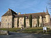
| Fortified Church of St. Arbogast |  |
Muttenz 47°31′20″N 7°38′44″E / 47.52222°N 7.64556°E |
Fortified church | 1100 | Only fortified church remaining in Switzerland. Still an active church |
| Waldenburg | |||||
| Muttenz | Ruined castle | ||||
| Muttenz | Ruined castle | ||||
| Muttenz | Ruined castle | ||||
| Eptingen | Ruined castle | ||||
| Wildenstein Castle |  |
Bubendorf 47°25′54″N 7°44′9″E / 47.43167°N 7.73583°E |
about 1200 | Owned by the municipality | |
| Zwingen |
Basel-Stadt[]

Gundeldingen
class=notpageimage|
Castles in Basel Stadt| Name | Image | Location | Type | Date | Notes |
|---|---|---|---|---|---|
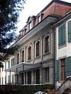
| Gundeldingen Castle |  |
Basel 47°32′24″N 7°35′32″E / 47.539944°N 7.592092°E |
Manor house | 14th century | Four castles of which parts remain of only two |
Bern[]

Aarberg
Aarwangen
Allmendingen
Amsoldingen
Aris ob Kien
Belp
Bipp
Blankenburg
Brandis
Burgdorf
Büren
Burgistein
Erguel
Erlach
Felsenburg
Gampelen
Grasburg
Grünenberg
Hindelbank
Hofwil
Hünegg
Hünigen
Jegenstorf
Landshut
Laupen
Upper Mannenberg
Mülenen
Münchenwiler
Münsingen
Nidau
Oberdiessbach
Oberhofen
Oberried
Restiturm
Riggisberg
Ringgenberg
Rümligen
Schlossberg
Schlosswil
Schadau
Schwarzenburg
Spiez
Tellenburg
Thorberg
Thun
Thunstetten
Toffen
Trachselwald
Unspunnen
Wangen an der Aare
Wartenstein
Weissenburg
Wimmis
Worb
Alt-Signau
Neu-Signau
Wiedlisbach
class=notpageimage|
Castles in the Canton of Bern
Bremgarten
Altes Bümpliz
Neues Bümpliz
Felsenburg
Gümligen
Holligen
Ittigen
Köniz
Kehrsatz
Lohn
Muri
Reichenbach
Wittigkofen
class=notpageimage|
Castles near Bern city| Name | Image | Location | Type | Date | Notes |
|---|---|---|---|---|---|
| Aarberg Castle |  |
Aarberg 47°2′37.32″N 7°16′32.52″E / 47.0437000°N 7.2757000°E |
13th century | residence of ministeriales. | |
| Aarwangen Castle |  |
Aarwangen 47°14′45″N 7°45′48″E / 47.245722°N 7.763425°E |
1300 | built by the Walter von Aarwangen. Owned by the Canton of Bern, open to the public | |
| Allmendingen Castle |  |
Allmendingen 46°55′00″N 7°31′20″E / 46.9166°N 7.5223°E |
Before 1239 | ||
| Amsoldingen Castle |  |
Amsoldingen 46°43′38″N 7°34′44″E / 46.727182°N 7.578859°E |
Castle | 10th century | Owned by the Canton of Bern, not open to the public |
| Aris ob Kien Castle | Reichenbach im Kandertal 46°36′31″N 7°41′44″E / 46.60861°N 7.69556°E |
12th century | |||
| Belp Castle |  |
Belp 46°53′34″N 7°30′07″E / 46.892701°N 7.501996°E |
|||
| Bipp Castle |  |
Oberbipp 47°15′49″N 7°39′08″E / 47.263592°N 7.652264°E |
Hill castle | by 1268 | residence of Ministerialis, Landvogt. |
| Blankenburg Castle |  |
Zweisimmen 46°32′23″N 7°23′12″E / 46.5397781°N 7.3867936°E |
c. 1329 | Owned by the Interessengemeinschaft Schloss Blankenburg, open to the public | |
| Brandis Castle | 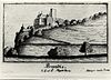 |
Lützelflüh 47°00′46″N 7°40′42″E / 47.012915°N 7.678318°E |
Hill castle | 13th Century | Residence of Freiherren von Brandis. Owned by the Interessengemeinschaft Schloss Blankenburg, open to the public |
| Bremgarten Castle |  |
Bremgarten 46°58′39″N 7°26′36″E / 46.9776°N 7.4433°E |
16th century | Owned by the Interessengemeinschaft Schloss Blankenburg, open to the public | |
| Burgdorf Castle |  |
Burgdorf 47°03′17″N 7°37′45″E / 47.054763°N 7.629163°E |
Castle | 1200 | built by the Berthold V, Duke of Zähringen. Owned by the Canton of Bern, open to the public |
| Altes Schloss Bümpliz |  |
Bümpliz 46°56′N 7°23′E / 46.94°N 7.39°E |
Open to the public | ||
| Neues Schloss Bümpliz |  |
Bümpliz 46°56′39″N 7°23′31″E / 46.94417°N 7.39194°E |
|||
| Büren Castle |  |
Büren an der Aare 47°08′24″N 7°22′17″E / 47.140074°N 7.37142°E |
1621-24 | Open to the public | |
| Burgistein Castle |  |
Burgistein 46°47′14″N 7°30′19″E / 46.787203°N 7.505297°E |
1260 | built by the Jordan I of Thun. Owned by the Canton of Bern, not open to the public | |
| Erguel Castle |  |
Sonvilier 47°08′08″N 6°58′37″E / 47.13567°N 6.97708°E |
before 1264 | Owned by the Canton of Bern, not open to the public | |
| Erlach Castle |  |
Erlach 47°02′40″N 7°05′39″E / 47.044537°N 7.094293°E |
1090-1100 | built by the Burkart von Fenis. Owned by the Canton of Bern, not open to the public | |
| Felsenburg |  |
Bern 46°56′57.89″N 7°27′30.5″E / 46.9494139°N 7.458472°E |
1260-1270 | Owned by the Canton of Bern, not open to the public | |
| Felsenburg Castle |  |
Kandergrund 46°31′55″N 7°40′24″E / 46.531894°N 7.673257°E |
12th century | built by the Freiherr of Kien, open to the public | |
| Gampelen | |||||
| Grasburg Castle |  |
Schwarzenburg 46°50′02″N 7°19′55″E / 46.833823°N 7.331811°E |
Castle Ruins | 11th-12th century | Owned by the Canton of Bern, open to the public |
| Grünenberg Castle |  |
Melchnau 47°11′N 7°52′E / 47.18°N 7.86°E |
Ruined castle | 11th-12th century | Owned by the Stiftung Burgruine Grünenberg Melchnau, open to the public |
| Gümligen Castle |  |
Muri bei Bern 46°56′05″N 7°30′55″E / 46.934693°N 7.515197°E |
Manor House | 1736 | Headquarters for Henri Guisan during WWII. |
| Muri bei Bern |
|||||
| Bolligen |
|||||
| Hindelbank Castle |  |
Hindelbank 47°02′00″N 7°32′28″E / 47.03333°N 7.54111°E |
Castle | 1721-25 | Open to the public |
| Hofwil Castle |  |
Münchenbuchsee 47°01′16″N 7°27′40″E / 47.021034°N 7.461037°E |
1784 | ||
| Holligen Castle | Bern 46°56′37″N 7°25′07″E / 46.94361°N 7.41861°E |
Castle | around 1500 | Built by Wilhelm von Diesbach, not open to the public | |
| Hünegg Castle | 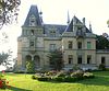 |
Hilterfingen 46°44′16″N 7°39′18″E / 46.737794°N 7.654931°E |
Manor house | 1861 | Built for Baron Albert Emil Otto von Parpart |
| Hünigen Castle |  |
Konolfingen 46°52′22″N 7°37′22″E / 46.872835°N 7.622867°E |
1554 | Built by the Niklaus von Scharnachtal. Owned by the Parkhotel Schloss Hünigen, open to the public | |
| Ittigen Castle |  |
Ittigen 46°58′30″N 7°29′01″E / 46.9750°N 7.4837°E |
17th century | Rebuilt at end of 17th century by Samuel Jenner | |
| Jegenstorf Castle |  |
Jegenstorf 47°02′52″N 7°30′35″E / 47.047829°N 7.509621°E |
12th century | built by the Lords of Jegistorf, open to the public | |
| Kehrsatz Castle | 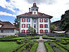 |
Kehrsatz 46°54′35″N 7°28′22″E / 46.90972°N 7.47278°E |
late 16th century | Open to the public | |
| Köniz Castle |  |
Köniz 46°55′15″N 7°24′50″E / 46.92089°N 7.413877°E |
11th century | Built for Augustinian Canons | |
| Landshut Castle | 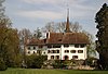 |
Utzenstorf 47°08′14″N 7°32′55″E / 47.137361°N 7.548613°E |
12th century | Built by the Dukes of Zähringen. Destroyed in Gümmenenkrieg (1332) and rebuilt. Owned by the Schweizer Museum für Wild und Jagd, open to the public | |
| Laupen Castle |  |
Laupen 46°54′08″N 7°14′30″E / 46.902194°N 7.241723°E |
10th-13th century | ||
| Ligerz | |||||
| Lohn Estate |  |
Kehrsatz 46°54′31″N 7°28′29″E / 46.90861°N 7.47472°E |
17th century | ||
| Melchnau | |||||
| Upper Mannenberg Castle |  |
Zweisimmen 46°34′18″N 7°22′55″E / 46.5717°N 7.3820°E |
Ruins | before 1190 | Owned by the Burg Mannenberg foundation, open to the public |
| Zweisimmen | |||||
| Muri bei Bern | |||||
| Moutier | |||||
| Mülenen Castle |  |
Reichenbach im Kandertal 46°38′16″N 7°41′31″E / 46.63776°N 7.692°E |
12th century | Built by the Freiherr of Kien, open to the public | |
| Münchenwiler Castle | 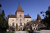 |
Münchenwiler 46°54′44″N 7°07′37″E / 46.912157°N 7.126946°E |
1100 | Owned by the Burg Mannenberg foundation, open to the public | |
| Münsingen Castle |  |
Münsingen 46°52′32″N 7°33′36″E / 46.875454°N 7.560106°E |
1550 | built by Hans Franz Nägeli. Now a museum | |
| Muri Castle |  |
Muri bei Bern 46°55′52″N 7°29′17″E / 46.93106°N 7.48807°E |
1650 | During French Revolution home of future King Charles X of France. Now privately owned | |
| Nidau Castle | 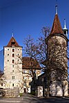 |
Nidau 47°07′40″N 7°14′25″E / 47.12778°N 7.240195°E |
13th century | Built by the Ulrich III or Rudolf I of Nidau. Owned by the Canton of Bern, open to the public | |
| Oberdiessbach Castle |  |
Oberdiessbach 46°50′20″N 7°37′34″E / 46.838927°N 7.626079°E |
Manor House | 1666-1668 | Open to the public |
| Oberhofen Castle | 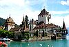 |
Oberhofen am Thunersee 46°43′47″N 7°40′07″E / 46.7297°N 7.6686°E |
water castle | 13th century | Residence of Freiherr, now Historical Museum of Bern, open to the public |
| Oberried Estate |  |
Belp 46°53′19″N 7°29′41″E / 46.888686°N 7.494615°E |
Manor house | 1735-6 | |
| Sigriswil | |||||
| Reichenbach Castle |  |
Zollikofen 46°59′26″N 7°26′57″E / 46.99056°N 7.44917°E |
14th century | Completely rebuilt in 1685 | |
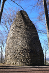
| Restiturm |  |
Meiringen 46°43′36.49″N 8°11′46.39″E / 46.7268028°N 8.1962194°E |
Ruined tower | 13th century | |
| Riggisberg Castle |  |
Riggisberg 46°34′18″N 7°22′55″E / 46.5717°N 7.3820°E |
Before 13th century | Second castle built 1700 | |
| Ringgenberg Castle |  |
Ringgenberg 46°42′04″N 7°53′49″E / 46.700988°N 7.897057°E |
Ruins / Church | 12th century | Castle burned in 1381, church built in ruins in 1670 |
| Rümligen Castle |  |
Rümligen 46°49′45″N 7°29′24″E / 46.829282°N 7.48987°E |
Around 1076 | Privately owned, not open to the public | |
| Schlossberg Castle |  |
La Neuveville 47°03′59″N 7°05′04″E / 47.0663°N 7.0844°E |
1283-88 | Built by Prince-Bishop Henry von Isny. | |
| Schlosswil Castle | 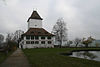 |
Schlosswil 46°54′29″N 7°36′29″E / 46.908139°N 7.608028°E |
12th century | Burned down in 1546, soon rebuilt. Owned by the Steinmann Foundation, not open to the public | |
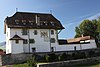
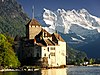
| Spiez Castle | 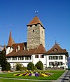 |
Spiez 46°41′20.95″N 7°41′14.56″E / 46.6891528°N 7.6873778°E |
933 | ||
| Sumiswald | |||||
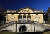
| Schadau Castle |  |
Thun 46°44′46″N 7°38′14″E / 46.746111°N 7.637222°E |
Manor house | 1846 | Home of the Swiss Gastronomy Museum |
| Schwarzenburg Castle |  |
Schwarzenburg 46°48′54″N 7°20′29″E / 46.815049°N 7.341401°E |
1573-76 | Owned by the Schloss Schwarzenburg foundation, open to the public | |
| Iseltwald | |||||
| Alt-Signau Castle |  |
Bowil 46°54′15″N 7°43′22″E / 46.9043°N 7.7227°E |
Ruined hill castle | about 1130 | |
| Neu-Signau Castle | Bowil 46°54′34″N 7°42′34″E / 46.9094°N 7.7095°E |
Ruined hill castle, spur castle | 14th Century | Residence of Freiherren von Signau. No above ground ruins remain | |
| Tellenburg Castle |  |
Frutigen 46°34′33″N 7°39′08″E / 46.575884°N 7.652103°E |
Ruined castle | 1200 | Ruined castle built by the Lords of Kien. Owned by the Canton of Bern, open to the public |
| Thielle | |||||
| Thorberg Castle |  |
Krauchthal 47°00′09″N 7°33′51″E / 47.0025°N 7.5643°E |
Former monastery | 12th-13th century | Carthusian monastery until 1528, lunatic asylum 1805, prison since 1849 |
| Thun Castle | 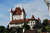 |
Thun 46°45′36.28″N 7°37′47.36″E / 46.7600778°N 7.6298222°E |
Keep | 12th century | Courthouse until 2009, museum since 1888 |
| Thunstetten Castle |  |
Thunstetten 47°12′19″N 7°45′13″E / 47.205406°N 7.753621°E |
Manor house | 1711 | Owned by the Thunstetten Castle Foundation |
| Toffen Castle |  |
Toffen 46°51′48″N 7°29′21″E / 46.863447°N 7.489037°E |
Castle | before 1306 | built by Johann von Bremgarten. Owned by the von May-von Werdt family, not open to the public |
| Trachselwald Castle |  |
Trachselwald 47°01′03″N 7°44′31″E / 47.017514°N 7.741878°E |
Hill castle | 11th or 12th century | |
| Unterseen | |||||
| Unspunnen Castle |  |
Wilderswil 46°40′07″N 7°51′26″E / 46.66861°N 7.85722°E |
Ruined castle | ||
| Wangen an der Aare Castle |  |
Wangen an der Aare 47°14′10″N 7°39′16″E / 47.236144°N 7.654504°E |
13th century | ||
| Wartenstein Castle |  |
Lauperswil 46°58′16″N 7°43′57″E / 46.9711°N 7.7325°E |
Ruined castle | Before 1228 | Burned during Burgdorferkrieg, 1383, never rebuilt |
| Wiedlisbach Castle |  |
Wiedlisbach 47°15′7.38″N 7°38′45.72″E / 47.2520500°N 7.6460333°E |
Tower house | 13th century | Built by the Count Ludwig the Elder von Frohburg. Rebelled during Swiss peasant war of 1653, captured and gate taken away by Bern |
| Weissenburg Castle |  |
Därstetten 46°39′30″N 7°28′24″E / 46.65833°N 7.473333°E |
Ruined hill castle | 13th century | residence of Freiherr. |
| Wimmis Castle |  |
Wimmis 46°40′21″N 7°38′04″E / 46.672515°N 7.634414°E |
Castle | 12th-13th century | built by the Lords of Wimmis/Strättligen. Owned by the Municipality of Wimmis, not open to the public |
| Wittigkofen Castle |  |
Bern 46°56′33″N 7°28′55″E / 46.942501°N 7.481927°E |
13th century | ||
| Worb Castle |  |
Worb 46°55′53″N 7°34′03″E / 46.931363°N 7.567573°E |
before 1130 | Built by the Freiherr de Worvo, not open to the public |
Fribourg[]
Chenaux
Poya
class=notpageimage|
Castles in Fribourg


Geneva[]

class=notpageimage|
Castles in Geneva


Glarus[]

class=notpageimage|
Castles in Glarus| Name | Image | Location | Type | Date | Notes |
|---|---|---|---|---|---|
| Vorburg |  |
Glarus Nord 47°07′05″N 9°03′26″E / 47.118015°N 9.057323°E |
13th century | Ruined castle |
Graubünden (Grisons)[]

Castelmur
Castello
Castelmur
Castelmur
Castels
Guardaval
Greifenstein
Marmels
Mesocco
Norantola
Planta
Riom
Servieze
Fracstein & Solavers
Spaniola
Spliatsch
San Peder
Sta. Maria
Steinsberg
Strassberg
Tarasp
Tschanüff
Wildenberg
Rhäzüns
Hochjuvalt
Ortenstein
Alt-Sins
Neu-Sins
Heinzenberg
Rietberg
Hasensprung
Schauenstein
Fürstenau
Campell
Ehrenfels
Hohenratien
Hochjuvalt
Ortenstein
Alt-Sins
Neu-Sins
Heinzenberg
Rietberg
Hasensprung
Schauenstein
Fürstenau
Campell
Ehrenfels
Hohenratien
class=notpageimage|
Castles in Graubünden| Name | Image | Location | Type | Date | Notes |
|---|---|---|---|---|---|
| Alt Aspermont Castle |  |
Trimmis 46°54′48″N 9°34′20″E / 46.91333°N 9.57222°E |
hill castle | 12th century | |
| Neu-Aspermont Castle |  |
Jenins 47°00′12″N 9°33′55″E / 47.003243°N 9.565202°E |
c. 1235 | Ruined castle built by the Lords of Aspermont. Owned by the Canton of Graubünden, open to the public | |
| Baldenstein Castle |  |
Sils im Domleschg 46°42′23″N 9°27′37″E / 46.70639°N 9.46028°E |
hill castle | around 1246 | Castle owned by the Canton of Graubünden, open to the public |
| Belfort Castle |  |
Brienz/Brinzauls 46°40′16″N 9°36′37″E / 46.671151°N 9.610291°E |
1222-31 | Ruined castle built by the Lords of Vaz. Owned by the Canton of Graubünden, open to the public | |
| Belmont Castle | 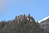 |
Flims 46°50′44″N 9°20′3″E / 46.84556°N 9.33417°E |
Höhenburg, Felslage | about 1000 | |
| Bernegg Castle | 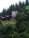 |
Calfreisen, Arosa 46°50′29″N 9°35′47.3″E / 46.84139°N 9.596472°E |
hill castle | about 1260 | Ruined castle. |
| Bishop's Castle or Unteres Schloss | 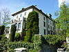 |
Fürstenau | about 1270 | Current structure dates to the early 18th century, while the site has been occupied since the 13th. | |
| Bothmar Castle | Malans | ||||
| Brandis Castle or Maienfeld Castle |  |
Maienfeld 47°00′23″N 9°31′51″E / 47.006394°N 9.530862°E |
Castle | 13th Century | |
| Cagliatscha Castle | 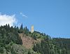 |
Andeer 46°36′50″N 9°25′20″E / 46.61389°N 9.42222°E |
hill castle | around 1265 | |
| Campell Castle or Campi |  |
Sils im Domleschg 46°42′1.6″N 9°28′17″E / 46.700444°N 9.47139°E |
hill castle | early 13th century | |
| Canaschal Castle |  |
Trin 46°49′41″N 9°21′56″E / 46.828056°N 9.365556°E |
Ruined castle south-east of Trin. Sometimes called Hohentrins or combined with Sogn Parcazi | ||
| Castelberg Castle |  |
Ilanz/Glion 46°45′24″N 9°12′35″E / 46.75667°N 9.20972°E |
hill castle | 13th century | Ruined castle |
| Castelmur Castle |  |
Bregaglia 46°20′23″N 9°33′42″E / 46.339828°N 9.5617°E |
1723 | Palazzo built for Johannes Redolfi, today a museum | |
| Castelmur Castle |  |
Bondo, Bregaglia 46°20′28″N 9°33′38″E / 46.341112°N 9.560451°E |
hill castle | before 842 | |
| Castels Castle |  |
Luzein 46°55′29″N 9°44′42″E / 46.92472°N 9.74500°E |
hill castle | 13th century | |
| Ehrenfels Castle |  |
Sils im Domleschg 46°41′48″N 09°27′06″E / 46.69667°N 9.45167°E |
hill castle | early 13th century | |
| Igis |
|||||
| Torre Fiorenzana |  |
Grono 46°15′01″N 9°09′01″E / 46.25023°N 9.150185°E |
late 12th century | Privately owned | |
| Fracstein Castle |  |
Seewis im Prättigau 46°58′33″N 9°37′00″E / 46.9759°N 9.6166°E |
Cave castle | about 1200 | Ruined castle |
| (Frundsberg) | Ruschein |
||||
| Friedau Castle |  |
Zizers 46°56′3.3″N 9°33′46″E / 46.934250°N 9.56278°E |
Lowland castle | about 1200 to 1300 | Ruined castle in the center of Zizers |
| Greifenstein Castle |  |
Filisur 46°40′34″N 9°41′35.41″E / 46.67611°N 9.6931694°E |
hill castle | 12th century | Ruined castle |
| Grottenstein Castle |  |
Haldenstein 46°53′2″N 09°31′22″E / 46.88389°N 9.52278°E |
Cave castle | about 1180 | Ruined castle |
| Grüneck Castle |  |
Ilanz/Glion 46°46′33.6″N 9°11′41.6″E / 46.776000°N 9.194889°E |
hill castle | around 1200 | Ruined castle |
| Guardaval Castle |  |
Madulain 46°35′08″N 9°55′59.59″E / 46.58556°N 9.9332194°E |
hill castle | 13th century | Ruined castle |
| Alt-Haldenstein Castle |  |
Haldenstein 46°52′50″N 9°31′24″E / 46.880556°N 9.523333°E |
Rock castle | around 1100 to 1299 | Ruined castle |
| Haldenstein Castle |  |
Haldenstein |
|||
| Hasensprung Castle |  |
Pratval village, Domleschg 46°43′53″N 9°26′38.3″E / 46.73139°N 9.443972°E |
hill castle | between 1200 and 1300 | Ruined castle |
| Heinzenberg Castle |  |
Präz village, Cazis 46°44′23″N 9°24′31″E / 46.73972°N 9.40861°E |
hill castle | about 1200 | Ruined castle |
| Hochjuvalt Castle |  |
Rothenbrunnen 46°46′40″N 9°25′15″E / 46.77778°N 9.42083°E |
hill castle | 12th century | Ruined castle |
| Hohenrätien Castle |  |
Sils im Domleschg 46°41′31″N 9°26′41″E / 46.69194°N 9.44472°E |
hill castle | 11th century | Ruined castle |
| Innerjuvalt Castle |  |
Rothenbrunnen 46°46′6″N 9°25′54″E / 46.76833°N 9.43167°E |
hill castle | around 1250 | Ruined castle |
| Jörgenberg Castle |  |
Waltensburg/Vuorz 46°46′49″N 09°08′17″E / 46.78028°N 9.13806°E |
hill castle, spur castle | 765 | Ruined castle |
| Klingenhorn Castle | 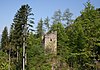 |
Malans 46°59′39″N 9°34′46.46″E / 46.99417°N 9.5795722°E |
hill castle | 13th century | Ruined castle |
| Kropfenstein Castle |  |
Waltensburg/Vuorz 46°46′12″N 9°06′05″E / 46.769868°N 9.101305°E |
13th century | Open to the public | |
| Lichtenstein Castle | 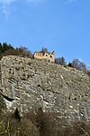 |
Haldenstein 46°53′4.2″N 09°31′35″E / 46.884500°N 9.52639°E |
hill castle | early 12th century | Ruined castle |
| Marmels Castle |  |
Marmorera 46°30′24″N 9°37′18.25″E / 46.50667°N 9.6217361°E |
Cave Castle | around 1100 | Ruined castle |
| Marschlins Castle |  |
Landquart 46°57′16.36″N 09°35′4.14″E / 46.9545444°N 9.5844833°E |
water castle | 13th century | Privately owned. Used as the residence of the Bishop of Chur. |
| Mesocco Castle |  |
Mesocco 46°22′48″N 9°13′57″E / 46.38000°N 9.23250°E |
Hill castle | Before 1219 | Ruined castle |
| Neuburg Castle | 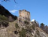 |
Untervaz 46°54′46″N 09°32′39″E / 46.91278°N 9.54417°E |
hill castle | about 1300 | Ruined castle |
| Vaz/Obervaz |
|||||
| Norantola Castle | 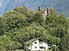 |
Cama 46°16′59.59″N 9°10′35″E / 46.2832194°N 9.17639°E |
hill castle | 12th century | Ruined castle |
| Ortenstein Castle |  |
Domleschg 46°45′35″N 9°26′07″E / 46.759765°N 9.435285°E |
hill castle | about 1250 | Privately owned |
| Pala Castle | 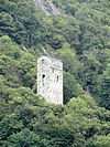 |
San Vittore 46°14′23.35″N 9°06′19.27″E / 46.2398194°N 9.1053528°E |
hill castle | 12th century | Ruined castle |
| Parpan Castle |  |
Churwalden 46°45′37.94″N 9°33′29.11″E / 46.7605389°N 9.5580861°E |
|||
| Planta Tower | 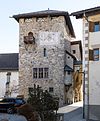 |
Zuoz 46°36′07.93″N 9°57′35.33″E / 46.6022028°N 9.9598139°E |
tower house | 13th century | Houses the archives of the Oberengadin Kreis |
| Rappenstein Castle | 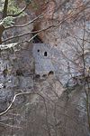 |
Untervaz 46°55′30″N 9°31′11″E / 46.92500°N 9.51972°E |
Cave castle | around 1250 | Ruined cave castle |
| Rhäzüns Castle | 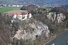 |
Rhäzüns 46°47′54.10″N 9°24′11.80″E / 46.7983611°N 9.4032778°E |
hill castle | 10th century | Home of the Barons of Rhäzüns |
| Reichenau |
|||||
| Rietberg Castle |  |
Pratval village, Domleschg 46°44′09″N 9°26′53″E / 46.735794°N 9.448035°E |
hill castle | early 13th century | Site of the murder of Pompeius Planta during the Bündner Wirren. |
| Riom Castle | 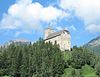 |
Surses 46°36′33.33″N 9°35′03.61″E / 46.6092583°N 9.5843361°E |
motte-and-bailey castle | around 1226 | |
| Trimmis |
|||||
| Salenegg Castle |  |
Maienfeld |
|||
| San Peder Castle |  |
Scuol 46°48′58.01″N 10°19′58.38″E / 46.8161139°N 10.3328833°E |
hill castle | 12th-13th century | Ruined tower and church |
| Santa Maria in Calanca |  |
Santa Maria in Calanca 46°15′44.50″N 09°08′44.84″E / 46.2623611°N 9.1457889°E |
hill castle | about 1300 | Ruined castle |
| Schauenstein Castle |  |
Fürstenau |
|||
| Schiedberg Castle |  |
Sagogn 46°47′30″N 09°16′0″E / 46.79167°N 9.26667°E |
hill castle | about 1000 | Ruined castle |
| Schwarzenstein Castle |  |
Obersaxen Mundaun 46°45′1.35″N 9°04′22″E / 46.7503750°N 9.07278°E |
hill castle | about 1250 | Ruined castle, residence of ministeriales. |
| Serviezel Castle |  |
Valsot 46°52′59″N 10°27′10″E / 46.88306°N 10.45278°E |
hill castle | 12th century | Ruined castle |
| Alt-Sins Castle or Alt-Süns Castle |  |
Paspels village, Domleschg 46°44′58″N 9°26′21″E / 46.74944°N 9.43917��E |
hill castle | about 1200 | Ruined castle |
| Neu-Sins Castle or Neu-Süns Castle |  |
Paspels 46°44′39″N 9°26′52″E / 46.74417°N 9.44778°E |
hill castle | between 1250 and 1300 | Ruined castle residence of ministeriales in service to the Vaz family. |
| Sogn Parcazi |  |
Trin 46°49′45.628″N 09°21′2.444″E / 46.82934111°N 9.35067889°E |
hill castle | about 750 (?) | Ruined fortified church and castle |
| Solavers Castle |  |
Seewis 46°59′00″N 9°38′39″E / 46.983375°N 9.644217°E |
hill castle | 11th century | Ruined castle |
| Spaniola Castle |  |
Pontresina 46°29′21.46″N 9°54′35.50″E / 46.4892944°N 9.9098611°E |
hill castle | around 1200 | Ruined castle |
| Spliatsch Castle |  |
Sur village, Surses 46°31′01″N 9°37′37″E / 46.51694°N 9.62694°E |
hill castle | around 1200 | Ruined castle |
| Splügen Castle |  |
Splügen 46°33′24″N 9°20′04″E / 46.55667°N 9.33444°E |
motte-and-bailey castle | around 1275 | Ruined castle residence of free nobility. |
| Steinsberg Castle | 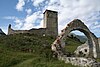 |
Ardez 46°46′27.40″N 10°12′18″E / 46.7742778°N 10.20500°E |
hill castle | 12th century | Ruined castle |
| Fideris |
|||||
| Strassberg Castle |  |
Churwalden 46°48′22.70″N 09°32′01.80″E / 46.8063056°N 9.5338333°E |
hill castle | around 1200 | |
| Masein |
|||||
| Tschanüff Castle |  |
Ramosch, Valsot 46°49′58.50″N 10°22′32.22″E / 46.8329167°N 10.3756167°E |
hill castle | 12th century | Ruined castle. Residence of ministerialis knights in service to the Bishop of Chur. |
| Obertagstein Castle |  |
Thusis 46°41′6″N 9°25′40″E / 46.68500°N 9.42778°E |
hill castle | about 1300 | Ruined castle |
| Tarasp Castle | 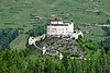 |
Scuol 46°46′44″N 10°15′42″E / 46.77889°N 10.26167°E |
hill castle | 11th century | Privately owned |
| Falera |
|||||
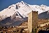
| Wildenberg Castle (Zernez) |  |
Zernez 46°41′59.1″N 10°5′46.4″E / 46.699750°N 10.096222°E |
13th century | ||
| Wynegg Castle | 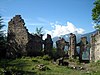 |
Malans 46°59′40″N 09°34′12″E / 46.99444°N 9.57000°E |
hill castle, spur castle | About 1200 | Ruined castle |
| Upper Castle Zizers |  |
Zizers |
|||
| Lower Castle Zizers |  |
Zizers |
Jura[]
class=notpageimage|
Castles in Jura| Name | Image | Location | Type | Date | Notes |
|---|---|---|---|---|---|
| Asuel Castle | 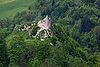 |
La Baroche 47°23′57″N 7°12′36″E / 47.399154°N 7.210003°E |
Ruined castle | ||
 |
Pleigne 47°25′45″N 7°18′58″E / 47.42926°N 7.31617°E |
Ruined castle | 13th/14th century | ||
| Mont-Terri Castle |  |
Cornol 47°23′28″N 7°09′40″E / 47.391222°N 7.161164°E |
Ruins | 1st century BC / 13th century | A ruined medieval castle above a prehistoric hillfort |
| Montvoie Castle | Clos du Doubs 47°21′57″N 7°03′24″E / 47.365919°N 7.056713°E |
||||
| Prince-Bishops' Castle |  |
Delémont 47°21′50″N 7°20′34″E / 47.363878°N 7.342824°E |
Château | 18th century | |
| Porrentruy Castle | 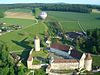 |
Porrentruy 47°25′10″N 7°04′21″E / 47.419486°N 7.072403°E |
13th century | Residence of the prince-bishops of Basel from 1527 until 1792, while they were in exile |
Lucerne[]

class=notpageimage|
Castles in Lucerne| Name | Image | Location | Type | Date | Notes |
|---|---|---|---|---|---|
| Beromünster | |||||
| Buttisholz Castle |  |
Buttisholz 47°06′54″N 8°05′49″E / 47.115101°N 8.097011°E |
|||
| Götzental Castle |  |
Dierikon 47°05′30″N 8°22′37″E / 47.091792°N 8.376996°E |
|||
| Heidegg Castle |  |
Gelfingen village, Hitzkirch 47°13′0.33″N 8°16′22.92″E / 47.2167583°N 8.2730333°E |
12th-13th century | residence of Home of Lords of Heidegg, then of Lucerne patricians, today museum. | |
| Huwyl Burg |  |
Römerswil |
Only appears on a 1665 map, ruins excavated in 1902 | ||
| Kastelen Tower Ruins |  |
Alberswil 47°08′49″N 7°59′35″E / 47.14695°N 7.99298°E |
hill castle | 1252 | Ruined castle tower |
| Bailiff's Castle (Willisau) | 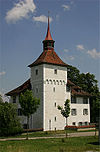 |
Willisau 47°07′10″N 7°59′26″E / 47.119313°N 7.990534°E |
|||
| Meggenhorn Castle |  |
Meggen 47°02′07″N 8°21′22″E / 47.035207°N 8.356217°E |
Manor house | 1868 | Houses a Welte Philharmonic Organ, used for concerts and as a reception hall |
| Neuhabsburg Castle |  |
Meggen 47°02′30″N 8°22′25″E / 47.041667°N 8.373611°E |
1244 | Destroyed in 1352. In 1871 a Gothic Revival castle built on site. Today privately owned | |
| Nünegg Castle |  |
Hohenrain 47°12′32″N 8°18′14″E / 47.208892°N 8.303861°E |
Ruined castle | ||
| Schauensee Castle |  |
Kriens 47°01′38″N 8°16′52″E / 47.02735556°N 8.28123611°E |
13th century | ||
| Wyher Castle | 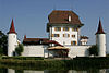 |
Ettiswil 47°8′31.3″N 8°1′25.6″E / 47.142028°N 8.023778°E |
Water castle | 1304 first mentioned | Museum since 1996 |
Neuchâtel[]


Nidwalden[]

class=notpageimage|
Castles in Nidwalden| Name | Image | Location | Type | Date | Notes |
|---|---|---|---|---|---|
| Rotzberg Castle |  |
Rotzberg by Ennetmoos 46°57′51″N 8°20′11″E / 46.964207°N 8.336464°E |
hill castle, spur castle | 10th-12th century | Ruined castle |
| Schnitzturm |  |
Stansstad 46°58′51″N 8°20′16″E / 46.980929°N 8.337663°E |
square tower | 1206/07 |
Obwalden[]

Hexenturm
Landenberg
Rosenberg
Rudenz
class=notpageimage|
Castles in Obwalden| Name | Image | Location | Type | Date | Notes |
|---|---|---|---|---|---|
| Hexenturm | 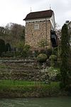 |
Sarnen 46°53′44″N 8°14′37″E / 46.895683°N 8.243706°E |
1285/86 | built by the Niklaus and Heinrich Kellner. | |
| Landenberg Castle |  |
Sarnen 46°53′48.16″N 8°14′37.94″E / 46.8967111°N 8.2438722°E |
11th century | Ruined castle, 18th century armory and firing range built on site | |
| Rosenberg Castle |  |
Giswil-Kleinteil 46°49′55.4″N 8°9′19.82″E / 46.832056°N 8.1555056°E |
13th century | Ruined bailiff's castle. | |
| Rudenz Castle |  |
Giswil-Rudenz 46°49′57″N 8°11′04″E / 46.832366°N 8.184432°E |
hill castle, spur castle | 1200 to 1250 | Ruined castle, residence of ministeriales family. |
Schaffhausen[]

class=notpageimage|
Castles in Schaffhausen| Name | Image | Location | Type | Date | Notes |
|---|---|---|---|---|---|
| Herblingen Castle |  |
Stetten 47°44′01″N 8°39′40″E / 47.7335°N 8.6612°E |
spur castle | 13th century | privately owned. |
| Hohenklingen Castle |  |
Stein am Rhein 47°40′0″N 8°51′30″E / 47.66667°N 8.85833°E |
hill castle, spur castle | 1225 | residence of Freiherren. |
| Munot | 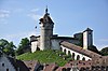 |
Schaffhausen 47°41′49″N 8°38′23″E / 47.69694°N 8.63972°E |
1563–1585 | City fortifications | |
| Wörth Castle |  |
Neuhausen am Rheinfall 47°40′37″N 8°36′49″E / 47.676838°N 8.61363°E |
water castle | Built on a river island at the Rheinfalls | |
| Radegg Castle |  |
47°39′06″N 8°30′24″E / 47.651700°N 8.506615°E |
hill castle, spur castle | 13th Century | Ruined castle residence of Freiherren von Radegg, destroyed around 1300. |
Schwyz[]

class=notpageimage|
Castles in Schwyz| Name | Image | Location | Type | Date | Notes |
|---|---|---|---|---|---|
| Alt Rapperswil Castle | Altendorf 47°11′06″N 8°50′28″E / 47.184953°N 8.841181°E |
Ruins | before 1200 | ||
| Schwanau Castle |  |
Lauerz 47°01′57″N 8°35′51″E / 47.032476°N 8.597395°E |
Ruins | about 12th century | |
| Gesslerburg |  |
Küssnacht 47°04′55″N 8°26′55″E / 47.082018°N 8.448663°E |
hill castle | about 9th century | Ruined castle |
| Grynau Castle | 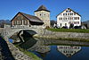 |
Tuggen 47°12′59″N 8°58′13″E / 47.216324°N 8.970278°E |
early 13th century | Today a country inn | |
| Pfäffikon Castle |  |
Freienbach 47°12′18″N 8°46′25″E / 47.20499°N 8.77357°E |
water castle | 13th century | Built by Einsiedeln Abbey as an abbot's residence |
Solothurn[]

Balm
Alt-Bechburg
Neu Bechburg
Blauenstein
Blumenstein
Buchegg
Dorneck
Neu-Falkenstein
Frohburg
Neu-Thierstein
Waldegg
class=notpageimage|
Castles in Solothurn| Name | Image | Location | Type | Date | Notes |
|---|---|---|---|---|---|
| Balm Castle ruins |  |
Balm bei Günsberg 47°15′20″N 7°33′18″E / 47.25556°N 7.55500°E |
Cave castle | 11th century | Ruined castle |
| Alt-Bechburg Castle |  |
Holderbank 47°19′56″N 7°46′18″E / 47.33222°N 7.77167°E |
hill castle | c. 1000-1100 | Ruined castle residence of counts. |
| Neu-Bechburg Castle |  |
Oensingen 47°17′50″N 7°43′07″E / 47.29722°N 7.71861°E |
hill castle | c. 1250 | residence of Freiherr. |
| Blauenstein |  |
Kleinlützel 47°25′53″N 7°24′58″E / 47.4315°N 7.4160°E |
Ruined Hill Castle | 13th century | |
| Blumenstein Castle |  |
Solothurn 47°12′59″N 7°32′13″E / 47.216436°N 7.536828°E |
Régence style house | 1725-28 | Today houses Historical Museum of Solothurn |
| Buchegg Castle |  |
Kyburg-Buchegg 47°08′29″N 7°30′34″E / 47.141475°N 7.509403°E |
1546 | ||
| Dorneck Castle |  |
Dornach 47°28′47.97″N 07°37′41.05″E / 47.4799917°N 7.6280694°E |
Ruined hill castle | c. 1050 | |
| Balsthal | |||||
| Neu-Falkenstein Castle |  |
Balsthal 47°19′22″N 7°42′36″E / 47.32278°N 7.71000°E |
Ruined hill castle | c. 1100 | |
| Frohburg Castle |  |
Trimbach 47°22′45″N 7°53′24″E / 47.37917°N 7.89000°E |
hill castle | c. 800 | Ruined castle, residence of counts. |
| Zullwil | |||||
 |
Metzerlen-Mariastein 47°27′54″N 7°29′04″E / 47.4651078°N 7.4843221°E |
||||
| Steinbrugg Castle |  |
Solothurn 47°12′44″N 7°32′48″E / 47.212217°N 7.546575°E |
Manor house | ||
| Hofstetten | |||||
| Neu-Thierstein Castle |  |
Büsserach 47°23′06″N 7°32′18″E / 47.384941°N 7.53822°E |
spur castle | c. 1180/1190 | Ruined castle |
| Waldegg Castle |  |
Feldbrunnen-St.Niklaus 47°13′24″N 7°32′54″E / 47.223378°N 7.54842°E |
1682-86 |
St. Gallen[]

Freudenberg
Forstegg
Hohensax
Iberg
Rapperswil
Wartau
Wartenstein
Werdenberg
Wichenstein
class=notpageimage|
Castles in St. Gallen| Name | Image | Location | Type | Date | Notes |
|---|---|---|---|---|---|
| Oberriet | |||||
| Wittenbach | |||||
| Freudenberg Castle |  |
Bad Ragaz 47°0′32″N 9°29′33″E / 47.00889°N 9.49250°E |
Ruined hill castle | about 1200-1250 | |
| Frischenberg Castle | Sennwald 47°13′54″N 9°26′57″E / 47.23167°N 9.44917°E |
Ruined hill castle | after 1313 | Ruined castle | |
| Forstegg Castle |  |
Sennwald 47°14′44″N 9°29′45″E / 47.24556°N 9.49583°E |
Ruined hill castle | about 1200 | Residence of Freiherr of Sax/Misox. |
| Fründsberg Castle | Goldingen 47°17′01″N 8°56′29″E / 47.283593°N 8.941272°E |
Ruined castle | |||
| Gräpplang Castle |  |
Flums-Gräpplang 47°06′10″N 09°19′56″E / 47.10278°N 9.33222°E |
hill castle, spur castle | about 1100-1200 | Ruined castle |
| Balgach | |||||
| Kleiner Hahnberg Castle | Berg 47°29′41″N 9°24′57″E / 47.494711°N 9.415868°E |
||||
| Balgach | |||||
| Hohensax Castle |  |
Sennwald 47°13′49″N 9°26′37″E / 47.23028°N 9.44361°E |
Ruined hill castle | 1200 | |
| Iberg Castle |  |
Wattwil 47°17′51″N 09°04′48″E / 47.29750°N 9.08000°E |
hill castle | 1200 | Owned by the municipality |
| Gossau | |||||
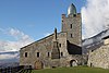
| Rapperswil Castle |  |
Rapperswil 47°13′38″N 8°48′56″E / 47.227337°N 8.815509°E |
water castle | 1220 | Home of the Polish Museum, Rapperswil |
| Sargans Castle |  |
Sargans 47°03′01″N 9°26′14″E / 47.050194°N 9.437282°E |
hill castle | 12th century | Today a museum |
| Wartau Castle |  |
Wartau 47°05′55.44″N 9°29′26.24″E / 47.0987333°N 9.4906222°E |
ruined hill castle | about 1225 | Ruined castle residence of Freiadelige. |
| Rorschacherberg | |||||
| Rorschacherberg | |||||
| Wartenstein Castle |  |
Pfäfers 46°59′39.30″N 9°30′37.94″E / 46.9942500°N 9.5105389°E |
ruined hill castle | about 1206 | Ruined castle |
| Werdenberg Castle |  |
Grabs 47°10′07″N 9°27′42″E / 47.168506°N 9.461647°E |
hill castle | 1228 | residence of counts of Werdenberg. |
| Wichenstein Castle | 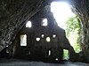 |
Oberriet 47°19′38″N 9°33′14″E / 47.327113°N 9.5539°E |
ruined cave castle | ||
| Zuckenriet Castle |  |
Niederhelfenschwil 47°29′19″N 9°09′49″E / 47.488677°N 9.163647°E |
Ticino[]

class=notpageimage|
Castles in Ticino| Name | Image | Location | Type | Date | Notes |
|---|---|---|---|---|---|
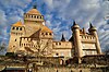
| Castelgrande | 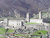 |
Bellinzona 46°11′34″N 9°01′20″E / 46.192889°N 9.022333°E |
Hill castle | 13th century | Part of UNESCO World Heritage Site |
| Montebello |  |
Bellinzona 46°11′29″N 9°01′36″E / 46.191333°N 9.026611°E |
Hill castle | 1313 | Part of UNESCO World Heritage Site, Houses a museum |
| Sasso Corbaro | 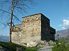 |
Bellinzona 46°11′17″N 9°01′49″E / 46.188183°N 9.030156°E |
Hill castle | 1478 | Part of UNESCO World Heritage Site, Houses a museum |
| S. Giorgio Castle | 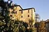 |
Magliaso 45°59′13″N 8°53′19″E / 45.986972°N 8.888557°E |
1033 | ||
| Pontegana Castle |  |
Balerna 45°50′35″N 9°00′57″E / 45.843009°N 9.015785°E |
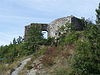
Ruined hill castle | 10th century | Castle ruins |
| Serravalle Castle |  |
Serravalle 46°24′46.10″N 8°58′20.8″E / 46.4128056°N 8.972444°E |
Ruined hill castle | 12th century | Ruined castle |
| Airolo | |||||
| Visconteo Castle | 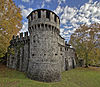 |
Locarno 46°10′04″N 8°47′36″E / 46.1679°N 8.7933°E |
12th or 13th century | Open to the public, houses a museum |
Thurgau[]

Altenburg
Altenklingen
Anwil
Arbon
Arenenberg
Bischofszell
Brunegg
Bürglen
Castell &
Ebersberg
Eppishausen
Freudenfels
Glarisegg
Gottlieben
Heitnau
Helfenberg
Heidelberg
Heuberg
Horn
Hubberg
Kefikon
Klingenberg
Last
Liebburg
Liebenfels
Mammertshofen
Neuburg
Roggwil
Schleifenrain
Sonnenberg
Steinegg
Weinfelden
Wellenberg
class=notpageimage|
Castles in Thurgau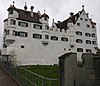


Uri[]

class=notpageimage|
Castles in Uri| Name | Image | Location | Type | Date | Notes |
|---|---|---|---|---|---|
| Apro Castle |  |
Seedorf 46°53′12″N 8°36′23″E / 46.88662°N 8.60639°E |
Rural mansion | 1555 | |
| Rudenz Castle | 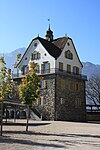 |
Flüelen 46°54′07″N 8°37′30″E / 46.90185°N 8.62489°E |
Early 13th century | Owned by the municipality, used for events | |
| Attinghausen Castle | 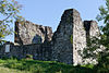 |
Attinghausen 46°51′44″N 8°37′47″E / 46.86222°N 8.62972°E |
about 1100 | Ruined castle | |
| Hospental Castle |  |
Hospental 46°37′07″N 8°34′00″E / 46.618691°N 8.566786°E |
spur castle | 13th century | Ruined castle, partially preserved |
| Meierturm |  |
Silenen 46°46′45″N 8°40′20″E / 46.779167°N 8.672222°E |
|||
| Schweinsberg Castle | 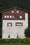 |
Attinghausen, Uri 46°51′51″N 8°37′34″E / 46.86417°N 8.62611°E |
13th century | built by the Knights of Schweinsberg. | |
| Seedorf Castle | Seedorf 46°53′08″N 8°36′23″E / 46.88552°N 8.60643°E |
Ruined castle | |||
| Silenen | |||||
| Zwing Uri Castle |  |
Silenen 46°46′28″N 8°40′14″E / 46.774444°N 8.670556°E |
13th century | Possibly destroyed in 1307 during the Burgenbruch, during founding of Swiss Confederation |
Vaud[]

Aigle
Allaman
Aubonne
Beaulieu
Chillon
Coppet
Donneloye
Duillier
Grandson
Hauteville
Morges
Nyon
Prangins
Rolle
La Sarraz
Vincy
Vufflens
Yverdon
class=notpageimage|
Castles in Vaud


Valais[]
Saint-Maurice
Stockalper
class=notpageimage|
Castles in Valais


Zug[]

Castles in Zug
- , Risch
- , Risch-Rotkreuz
- , Hünenberg
- St. Andreas Castle, Cham
- , Baar
- Zug Castle, Zug
Zürich[]

Castles in Zürich
- Au Castle, Wädenswil
- Ruins of Baldern Castle, Stallikon
- Ruins of , Wald
- Ruins of , Hinwil
- Ruins of Alt-Bichelsee Castle, Bichelsee
- Ruins of , Turbenthal
- Bubikon Castle, Bubikon
- Ruins of , Dübendorf
- , Eglisau
- Elgg Castle, Elgg
- Flaach Castle, Flaach
- Ruins of ,
- Ruins of , Meilen
- Ruins of , Friesenberg, Zurich
- ,
- Ruins of Glanzenberg Castle, Unterengstringen
- Greifenberg Castle, Bäretswil
- Greifensee Castle, Greifensee
- , Grüningen
- Hegi Castle, Winterthur
- Ruins of Hohenlandenberg Castle, Wila
- Irgenhausen Castrum, Irgenhausen
- Kyburg Castle, Kyburg
- Ruins of , Bauma
- Ruins of , Boppelsen
- Laufen Castle, Laufen-Uhwiesen
- , Zell
- , Stadel (Winterthur)
- Ruins of Alt-Regensberg Castle, Regensdorf
- Neu-Regensberg Castle, Regensberg
- Ruins of , Turbenthal
- Ruins of Schnabelburg Castle, Hausen am Albis
- , Waltalingen
- Ruins of , Steinmaur
- Ruins of , Wildberg und Turbenthal
- Ruins of , Uetliberg
- Uster Castle, Uster
- Ruins of Alt Wädenswil Castle, Richterswil
- Wart Castle, Neftenbach
- , Wiesendangen
- Ruins of , Wildberg
- Ruins of Alt-Wülflingen Castle, Wülflingen in Winterthur
- Wülflingen Castle, Wülflingen in Winterthur
- Ruins of Wulp Castle, Küsnacht
- Wyden Castle, Ossingen
See also[]
| Wikimedia Commons has media related to Castles in Switzerland. |
- Castles in Switzerland
- List of castles
- List of cathedrals in Switzerland
- List of museums in Switzerland
- Lists of tourist attractions in Switzerland
| Africa | 
 | |
|---|---|---|
| Americas |
| |
| Asia | ||
| Europe |
| |
Categories:
- Castles in Switzerland
- Lists of buildings and structures in Switzerland
- Lists of castles in Europe
- Lists of castles by country
- Lists of tourist attractions in Switzerland