List of crossings of the River Derwent, Derbyshire

From Wikipedia, the free encyclopedia

This is a list of crossings of the Derbyshire Derwent, the principal river of Derbyshire in the Midlands of England.

Listed in the table are those crossings that have been identified from the first formal crossing at the packhorse bridge at Slippery Stones, in the upper Derwent valley, continuing through the Derwent Valley Mills heritage site to Derby, to the last crossing near Church Wilne upstream of Derwent Mouth where the Derwent meets the River Trent.[1]

Described by Defoe in 1726 as a "fury of a river" the Derwent could only be forded at a number of particular locations, which could still be impassable during winter floods.[2] Wooden bridges provided for a more reliable crossing, but were easily damaged by those same floods. The wooden bridge at Leadmill was destroyed before it was completed in the early 1700s.[3] Toad-Moor Bridge near Ambergate was rebuilt as Halfpenny Bridge by Francis Hurt in 1792, after being swept away in a flood of 1791. In the Candlemas flood of February 1795, the bridges at Belper and Whatstandwell were washed away, but were subsequently rebuilt soon after.[4][5]

Glover in his History of the County of Derby of 1829 noted that there were a number of bridges, fords and a ferry across the Derwent. There were fords at Wilne Mills, Alvaston, Little Eaton and Ambaston, and a ferry at Matlock Bath. Wooden bridges were mentioned at Wilne Mills, Borrowash Mills and Exeter Bridge, downstream of which was a long wooden bridge for canal towing horses. Tolls were levied at Wilne Mills, Darley Abbey, and Milford, where there was also a chain-bridge for mill workers. He also recorded a number of county bridges and stone-arched bridges, the majority of which are now listed structures, and in some cases scheduled monuments. A number of these bridges were built by the local industrial families of the Derwent valley, including those of Hurt, Strutt and Evans.[4]

Map all coordinates using: OpenStreetMap 
Download coordinates as: KML

Crossings[]

Key to heritage status
Status Criteria[6]
I Grade I listed. Bridge of exceptional interest, sometimes considered to be internationally important
II* Grade II* listed. Particularly important bridge of more than special interest
II Grade II listed. Bridge of national importance and special interest
SM
Scheduled Monument. Nationally important archaeological bridge.
River order Name Image Location
Coordinates
Carries Date Heritage
status
Notes
1 Slippery Stones packhorse bridge An infant River Derwent passes under the packhorse bridge at Slippery Stones - geograph.org.uk - 1140307.jpg Hope Woodlands
53°27′09″N 1°44′48″W / 53.45260°N 1.74661°W / 53.45260; -1.74661 (Slippery Stones)
Footpath 1672
(1959)
II A 17th-century packhorse bridge that was relocated from Derwent village[7][8]
2 Howden Dam Howden Dam - geograph.org.uk - 185883.jpg Howden Reservoir
53°26′00″N 1°45′00″W / 53.43333°N 1.75000°W / 53.43333; -1.75000 (Howden Dam)
1912 II For information[9]
3 Derwent Dam Derwent dam.jpg Derwent Reservoir
53°24′18″N 1°44′30″W / 53.40503°N 1.74167°W / 53.40503; -1.74167 (Derwent Dam)
1916 II For information[9]
4 Fairholmes Bridge Bridge at Fairholmes across the Derwent (geograph 3856165).jpg Derwent Reservoir
53°24′09″N 1°44′32″W / 53.40260°N 1.74219°W / 53.40260; -1.74219 (Fairholmes Bridge)
Derwent Lane - Stone arch bridge[10]
5 Ashopton Viaduct Ashopton Viaduct Arches - photoshopped 559803.jpg Ladybower Reservoir
53°22′29″N 1°42′41″W / 53.37465°N 1.71147°W / 53.37465; -1.71147 (Ashopton Viaduct)
A57 1943 - Concrete viaduct[10]
6 Ladybower Dam Ladybower Dam Wall - geograph.org.uk - 859996.jpg Ladybower Reservoir
53°21′57″N 1°42′04″W / 53.3657°N 1.7011°W / 53.3657; -1.7011 (Ladybower Dam)
Footpath 1943 - Footway along dam wall[11]
7 Yorkshire Bridge Yorkshire Bridge - geograph.org.uk - 470176.jpg Yorkshire Bridge
53°21′40″N 1°42′14″W / 53.36123°N 1.70386°W / 53.36123; -1.70386 (Yorkshire Bridge)
Lydgate Lane 1800s II Stone arch bridge[11][12]
8 Bamford Mill footbridge Footbridge over the Derwent (geograph 1922544).jpg Bamford
53°20′48″N 1°41′39″W / 53.34659°N 1.69411°W / 53.34659; -1.69411 (Bamford Mill footbridge)
Footpath - Wooden footbridge at Bamford Mill[13]
9 Water Lane bridge Water Lane, Bamford (geograph 1945624).jpg Bamford
53°20′34″N 1°41′34″W / 53.34284°N 1.69273°W / 53.34284; -1.69273 (Water Lane bridge)
Water Lane - Minor road bridge[13]
10 Railway bridge Bamford
53°20′25″N 1°41′32″W / 53.34014°N 1.69230°W / 53.34014; -1.69230 (Railway bridge)
Hope Valley line - Rail bridge[13]
11 Mytham Bridge Mytham Bridge (geograph 3233323).jpg Bamford
53°20′21″N 1°41′38″W / 53.33917°N 1.69388°W / 53.33917; -1.69388 (Mytham Bridge)
A6187 - Stone arch bridge with adjacent footbridge[13]
12 Hathersage stepping stones Stepping Stones, River Derwent - geograph.org.uk - 133468.jpg Hathersage
53°19′50″N 1°40′31″W / 53.33048°N 1.67540°W / 53.33048; -1.67540 (Hathersage stepping stones)
Footpath - Between Offerton and Hathersage[14]
13 Leadmill Bridge The River Derwent at Leadmill Bridge - geograph.org.uk - 1366671.jpg Hathersage
53°19′19″N 1°39′04″W / 53.32187°N 1.65102°W / 53.32187; -1.65102 (Leadmill Bridge)
B6001 18th century II Stone arch bridge – widened in 1928[14][15]
14 Grindleford Bridge Derbyshire England.jpg Grindleford
53°17′48″N 1°38′03″W / 53.29675°N 1.63415°W / 53.29675; -1.63415 (Grindleford Bridge)
B6251 II & SM Stone arch bridge[16][17]
15 Froggatt Bridge Froggatt bridge - geograph.org.uk - 578978.jpg Froggatt
53°16′52″N 1°38′09″W / 53.28116°N 1.63585°W / 53.28116; -1.63585 (Froggatt Bridge)
Minor Road 19th century
SM
Stone arch bridge[16][18]
16 Froggatt New Bridge New Bridge, Calver, Derbyshire - geograph.org.uk - 63898.jpg Froggatt
53°16′28″N 1°38′08″W / 53.27445°N 1.63565°W / 53.27445; -1.63565 (Froggatt New Bridge)
A625 - Stone arch bridge[16]
17 Calver Bridge River Derwent at Calver.jpg Calver
53°16′00″N 1°37′53″W / 53.26657°N 1.63146°W / 53.26657; -1.63146 (Calver Bridge)
Minor road 19th century II* Triple arched stone bridge[16][19]
18 Calver Bridge (A623) Baslow Road Bridge, Calver - 1 (geograph 3356523).jpg Calver
53°15′59″N 1°37′55″W / 53.26625°N 1.63206°W / 53.26625; -1.63206 (Calver Bridge (A623))
A623 1974 - Modern bridge[16]
19 Baslow road bridge over river Derwent (geograph 3125886).jpg Baslow
53°14′52″N 1°37′31″W / 53.24775°N 1.62527°W / 53.24775; -1.62527 (Baslow Bridge)
Minor road 1608 I & SM Stone arch bridge with toll booth[20][21]
20 Devonshire Bridge River Derwent (geograph 4771147).jpg Baslow
53°14′46″N 1°37′24″W / 53.24604°N 1.62337°W / 53.24604; -1.62337 (Devonshire Bridge)
A619 1925 - Bakewell Road bridge[20]
21 Chatsworth Park Bridge Chatsworth Bridge.jpg Chatsworth
53°13′41″N 1°36′58″W / 53.22800°N 1.61622°W / 53.22800; -1.61622 (Chatsworth Park Bridge)
Minor road 1774 I Designed by James Paine, providing access to Chatsworth House[20][22]
22 One Arch Bridge Bridge over the River Derwent.jpg Chatsworth
53°12′45″N 1°36′40″W / 53.21241°N 1.61106°W / 53.21241; -1.61106 (One Arch Bridge)
B6012 1760 II* & SM Also designed by James Paine, linking Edensor to Beeley[23][24]
23 Rowsley Viaduct Old railway viaduct over the River Derwent (geograph 3290713).jpg Rowsley
53°11′25″N 1°37′06″W / 53.19038°N 1.61842°W / 53.19038; -1.61842 (Rowsley Viaduct)
Unused 1862 - Former railway viaduct[25]
24 Rowsley Bridge Bridge over the Derwent at Rowsley - geograph.org.uk - 591671.jpg Rowsley
53°11′22″N 1°37′02″W / 53.18957°N 1.61720°W / 53.18957; -1.61720 (Rowsley Bridge)
A6 15th century II* & SM Stone arch bridge widened 1926[26][27]
25 Darley Bridge Darley Bridge and River Derwent - geograph.org.uk - 1739358.jpg Darley Bridge
53°09′18″N 1°35′49″W / 53.15508°N 1.59697°W / 53.15508; -1.59697 (Darley Bridge)
B5057 15th century II* & SM Stone arch bridge[28][29]
26 Peak Rail bridge Bridge carrying Peak Rail line over the River Derwent - geograph.org.uk - 1241438.jpg Matlock
53°08′31″N 1°34′08″W / 53.14200°N 1.56899°W / 53.14200; -1.56899 (Peak Rail bridge)
Peak Rail - Bridge 35[30]
27 Derwent Way bridge New A6 bridge over the Derwent (geograph 2336107).jpg Matlock
53°08′27″N 1°33′53″W / 53.14074°N 1.56464°W / 53.14074; -1.56464 (Derwent Way bridge)
A6 2007 - Modern A6 bridge[31]
28 Matlock Bridge Matlock Bridge - geograph.org.uk - 937223.jpg Matlock
53°08′16″N 1°33′22″W / 53.13788°N 1.55622°W / 53.13788; -1.55622 (Matlock Bridge)
Former A6 route restored and widened 1904 15th century II* & SM Stone arch bridge[32][33]
29 Hall Leys Park footbridge Bridge over the River Derwent (geograph 5861653).jpg Matlock
53°08′12″N 1°33′15″W / 53.13659°N 1.55414°W / 53.13659; -1.55414 (Hall Leys Park footbridge)
Footpath - The gateway to the bridge shows flood heights in 1960 and 1965[32]
30 Railway bridge Matlock - railway bridge over River Derwent (geograph 2242669).jpg Matlock
53°08′05″N 1°33′23″W / 53.13486°N 1.55643°W / 53.13486; -1.55643 (Railway bridge)
Derwent Valley Line - Rail bridge[32]
31 Footbridge Matlock - footbridge to Pic Tor (Geograph-2242688-by-Dave-Bevis).jpg Matlock
53°08′00″N 1°33′25″W / 53.13333°N 1.55684°W / 53.13333; -1.55684 (Footbridge)
Footpath - Dale Road to Pic Tor[32]
32 Footbridge Slalom course on the river (geograph 5969587).jpg Matlock Bath
53°07′34″N 1°33′35″W / ���53.12600°N 1.55975°W / 53.12600; -1.55975 (Footbridge)
Footpath - Dale Road to High Tor[32]
33 Footbridge Footbridge over the Derwent (geograph 2323218).jpg Matlock Bath
53°07′26″N 1°33′28″W / 53.12386°N 1.55791°W / 53.12386; -1.55791 (Footbridge)
Footpath - Dale Road to cable car[32]
34 Matlock Bath Bridge Matlock Bath Bridge (geograph 3912459).jpg Matlock Bath
53°07′19″N 1°33′28″W / 53.12189°N 1.55786°W / 53.12189; -1.55786 (Matlock Bath Bridge)
Access road - Access road to Station Yard[32]
35 Jubilee Bridge, Matlock Bath Jubilee Bridge 1887 - geograph.org.uk - 1639920.jpg Matlock Bath
53°07′17″N 1°33′42″W / 53.12142°N 1.56154°W / 53.12142; -1.56154 (Jubilee Bridge, Matlock Bath)
Footpath 1887 - Footbridge[32]
36 Derwent Gardens footbridge Footbridge in Derwent Gardens (geograph 4595667).jpg Matlock Bath
53°07′03″N 1°33′36″W / 53.11752°N 1.55990°W / 53.11752; -1.55990 (Derwent Gardens footbridge)
Footpath 1969 - Modern footbridge linking Derwent Gardens to Lovers Walk; site of earlier Matlock ferry[32]
37 Cromford Bridge Cromford Bridge - geograph.org.uk - 11273.jpg Cromford
53°06′40″N 1°33′11″W / 53.11101°N 1.55310°W / 53.11101; -1.55310 (Cromford Bridge)
Mill Road 15th century II* & SM Stone arch bridge[34][35]
38 Cromford railway bridge Railway bridge over the River Derwent (geograph 3891047).jpg Cromford
53°06′43″N 1°32′53″W / 53.11206°N 1.54809°W / 53.11206; -1.54809 (Cromford railway bridge)
Derwent Valley Line - Rail bridge[34]
39 Access bridge (High peak junction) Vehicle Bridge over River Derwent - geograph.org.uk - 490094.jpg High Peak Junction
53°06′03″N 1°31′54″W / 53.10074°N 1.53171°W / 53.10074; -1.53171 (Access bridge (High peak junction))
Access road - Access to sewage works[34]
40 Footbridge Footbridge over River Derwent - geograph.org.uk - 490084.jpg High Peak Junction
53°06′02″N 1°31′53″W / 53.10060°N 1.53127°W / 53.10060; -1.53127 (Footbridge)
Footpath - High Peak Junction[34]
41 Leawood railway bridge Leawood railway bridge - geograph.org.uk - 1522398.jpg High Peak Junction
53°05′52″N 1°31′44″W / 53.09778°N 1.52882°W / 53.09778; -1.52882 (Leawood railway bridge)
Derwent Valley Line - Rail bridge[34]
42 Wigwell Aqueduct Wigwell Aqueduct - geograph.org.uk - 1522396.jpg High Peak Junction
53°05′49″N 1°31′47″W / 53.09693°N 1.52983°W / 53.09693; -1.52983 (Wigwell Aqueduct)
Cromford Canal 1790s
SM
Partially collapsed during construction; rebuilt at William Jessop's own expense[34][36]
43 Railway bridge High Peak Junction
53°05′45″N 1°31′19″W / 53.09595°N 1.52191°W / 53.09595; -1.52191 (Railway bridge)
Derwent Valley Line - Rail bridge[37]
44 Homesford footbridge Footbridge over the River Derwent (geograph 3085087).jpg Whatstandwell
53°05′40″N 1°30′51″W / 53.09447°N 1.51415°W / 53.09447; -1.51415 (Homesford footbridge)
Footpath - Combined foot and pipe bridge[37]
45 Railway bridge Railway Bridge over The Derwent - geograph.org.uk - 1354699.jpg Whatstandwell
53°05′23″N 1°30′25″W / 53.08979°N 1.50692°W / 53.08979; -1.50692 (Railway bridge - Whatstandwell)
Derwent Valley Line - Rail bridge[37]
46 Whatstandwell Bridge A Swollen Derwent Passes Under The Bridge - geograph.org.uk - 994005.jpg Whatstandwell
53°05′08″N 1°30′25″W / 53.08549°N 1.50704°W / 53.08549; -1.50704 (Whatstandwell Bridge)
A6 1796 II Stone arch bridge[37][38]
47 Oak Hurst mills bridge Ambergate
53°04′00″N 1°29′31″W / 53.06674°N 1.49193°W / 53.06674; -1.49193 (Oak Hurst mills bridge)
Access road - Access bridge[39]
48 Halfpenny Bridge Ambergate Halfpenny Bridge Derbyshire England.jpg Ambergate
53°03′34″N 1°29′02″W / 53.05942°N 1.48389°W / 53.05942; -1.48389 (Halfpenny Bridge)
Holly Lane 1792 II Also known as Toad-Moor bridge, built as a toll bridge by Francis Hurt[39][40]
49 Derwent Viaduct Ambergate railway bridge over River Derwent Derbyshire England.jpg Ambergate
53°03′24″N 1°28′58″W / 53.05672°N 1.48288°W / 53.05672; -1.48288 (Derwent Viaduct)
Midland Main Line 1840 II* Skewed rail bridge[39][41]
50 Railway bridge Wyver Lane - View towards the Derwent and Railway - geograph.org.uk - 1193001.jpg Belper
53°02′45″N 1°29′06��W / 53.0458°N 1.4849°W / 53.0458; -1.4849 (Railway bridge)
Midland Main Line - Rail bridge[42]
51 Railway bridge Belper- crossing the Derwent (geograph 5492130).jpg Belper
53°01′56″N 1°28′59″W / 53.0321°N 1.4830°W / 53.0321; -1.4830 (Railway bridge)
Midland Main Line - Rail bridge[42]
52 Belper Bridge Belper - road bridge and North Mill from River Derwent path - geograph.org.uk - 630207.jpg Belper
53°01′46″N 1°29′14″W / 53.02936°N 1.48725°W / 53.02936; -1.48725 (Belper Bridge)
Bridge Foot 1798 II Tripled arched bridge[42][43]
53 Belper Meadows footbridge The Derwent Passes under a Small Bridge - geograph.org.uk - 1350568.jpg Belper
53°01′30″N 1°29′30″W / 53.02505°N 1.49173°W / 53.02505; -1.49173 (Belper Meadows footbridge)
Footpath - Access bridge[42]
54 Belper sewage works bridge Sewage Works Access Road over River Derwent - geograph.org.uk - 736139.jpg Belper
53°00′58″N 1°29′06″W / 53.01619°N 1.48501°W / 53.01619; -1.48501 (Belper sewage works bridge)
Access road - Access bridge[42]
55 Swainsley Railway bridge Swainsley River Derwent Viaduct (geograph 5324465).jpg Belper
53°00′40″N 1°29′04″W / 53.01125°N 1.48433°W / 53.01125; -1.48433 (Swainsley Railway bridge)
Midland Main Line - Steel rail bridge[42]
56 Milford Bridge Milford Bridge - geograph.org.uk - 1117824.jpg Milford
53°00′08″N 1°28′42″W / 53.00231°N 1.47840°W / 53.00231; -1.47840 (Milford Bridge)
A6 1790 II Stone arch bridge[44]
57 Milford footbridge Milford - Leaving the Riverside Garden Centre (over the River Derwent) (geograph 2421660).jpg Milford
53°00′03″N 1°28′46″W / 53.00096°N 1.47936°W / 53.00096; -1.47936 (Milford footbridge)
Footpath - Garden centre access[44][45]
58 Moscow Farm bridge Milford
52°59′45″N 1°28′53″W / 52.99587°N 1.48139°W / 52.99587; -1.48139 (Moscow Farm bridge)
Access road - Access bridge[44]
59 Duffield Church Bridge Duffield - Makeney Road bridge over River Derwent (geograph 2828936).jpg Duffield
52°58′58″N 1°28′47″W / 52.98290°N 1.47961°W / 52.98290; -1.47961 (Duffield Church Bridge)
Makeney Road Probable 16th century II & SM Stone arch bridge[44][46]
60 Burley Railway Bridge The River Derwent near Little Eaton (geograph 2964793).jpg Little Eaton
52°58′11″N 1°28′17″W / 52.96981°N 1.47143°W / 52.96981; -1.47143 (Burley Railway Bridge)
Midland Main Line - Rail bridge[47]
61 Allestree Ford Bridge Allestree Ford Bridge - geograph.org.uk - 1012764.jpg Allestree
52°57′27″N 1°27′58″W / 52.95760°N 1.46619°W / 52.95760; -1.46619 (Allestree Ford Bridge)
Ford Lane - Former ford at this point[47]
62 Allestree A38 Bridge The Derwent from Allestree Ford Bridge - geograph.org.uk - 1012348.jpg Allestree
52°57′20″N 1°28′03″W / 52.95568°N 1.46759°W / 52.95568; -1.46759 (Allestree A38 Bridge)
Abbey Hill - Dual carriageway bridge[47]
63 Darley Abbey toll bridge Darley Abbey - panoramio (11).jpg Darley Abbey
52°56′36″N 1°28′33″W / 52.94332°N 1.47584°W / 52.94332; -1.47584 (Darley Abbey toll bridge)
Haslams Lane - Toll bridge[47]
64 Handyside Bridge Handyside Bridge - geograph.org.uk - 1024114.jpg Derby
52°55′51″N 1°28′39″W / 52.93092°N 1.47747°W / 52.93092; -1.47747 (Handyside Bridge)
Footpath 1878 II Former GNR railway bridge[48][49]
65 St Marys Bridge Derby - St Marys Bridge (geograph 3243722).jpg Derby
52°55′38″N 1°28′31″W / 52.92716°N 1.47519°W / 52.92716; -1.47519 (St Marys Bridge)
Minor road 1793 II* & SM Designed by Thomas Harrison, it replaced an earlier medieval bridge; adjacent is St Mary's Bridge Chapel.[48][50]
66 Causey Bridge Under Causey Bridge - geograph.org.uk - 1026489.jpg Derby
52°55′36″N 1°28′31″W / 52.92667°N 1.47521°W / 52.92667; -1.47521 (Causey Bridge)
Saint Alkmunds Way 1972 - Dual carriageway bridge[48]
67 Cathedral Green Footbridge Cathedral Green Footbridge – Derby.jpg Derby
52°55′31″N 1°28′31″W / 52.92525°N 1.47522°W / 52.92525; -1.47522 (Cathedral Green footbridge)
Footpath 2009 - Swing bridge[51]
68 Exeter Bridge Exeter Bridge.jpg Derby
52°55′26″N 1°28′26″W / 52.92397°N 1.47382°W / 52.92397; -1.47382 (Exeter Bridge)
Derwent Street 1929 - 1920s road bridge, replaced earlier wooden bridge[48]
69 Holmes Bridge The Derwent from Exeter Bridge (geograph 4180040).jpg Derby
52°55′24″N 1°28′11″W / 52.92343°N 1.46968°W / 52.92343; -1.46968 (Holmes Bridge)
A601 1972 - Dual carriageway bridge[48]
70 Bass Recreation Ground footbridge Foot Bridge Spanning the Derwent - geograph.org.uk - 1058254.jpg Derby
52°55′17″N 1°27′57″W / 52.92139°N 1.46592°W / 52.92139; -1.46592 (Bass Recreation Ground footbridge)
Footpath - Modern footbridge[48]
71 Derwent Bridge Derwent Bridge 3479.jpg Derby
52°55′10″N 1°27′50″W / 52.91952°N 1.46376°W / 52.91952; -1.46376 (Derwent Bridge)
Midland Main Line 1840 II Skewed rail bridge, also known as Five Arches[48][52]
72 Derwent Parade bridge Bridge carrying Derwent Parade over the Derwent - geograph.org.uk - 1058467.jpg Pride Park
52°55′03″N 1°26′35″W / 52.91761°N 1.44309°W / 52.91761; -1.44309 (Derwent Parade bridge)
Derwent Parade - Modern road bridge[48]
73 Railway bridge Pride Park Railway over the River Derwent - geograph.org.uk - 1059491.jpg Pride Park
52°54′40″N 1°26′26″W / 52.91104°N 1.44067°W / 52.91104; -1.44067 (Railway bridge Pride Park)
Midland Main Line - Midland Main Line[48]
74 Raynesway Bridge The A5111 crosses the River Derwent - geograph.org.uk - 1022741.jpg Derby
52°54′17″N 1°25′50″W / 52.90467°N 1.43049°W / 52.90467; -1.43049 (Raynesway Bridge)
A5111 1938 - A5111[53]
75 Waste Incinerator bridge Bridge over the Derwent at Derby (geograph 2524345).jpg Derby
52°54′16″N 1°25′39″W / 52.90440°N 1.42760°W / 52.90440; -1.42760 (Waste Incinerator bridge)
Access road - Access to incinerator[53]
76 Fernhook Avenue bridge New Bridge over the Derwent - geograph.org.uk - 1103140.jpg Derby
52°54′10″N 1°24′42″W / 52.90280°N 1.41177°W / 52.90280; -1.41177 (Fernhook Avenue bridge)
Access road 2009 - Access to Derby commercial park[54]
77 Access bridge Bridge Over the Derwent - geograph.org.uk - 1023431.jpg Borrowash
52°54′06″N 1°23′24″W / 52.90161°N 1.39012°W / 52.90161; -1.39012 (Access bridge)
Access road - Borrowash[55]
78 Borrowash Bridge Borrowash Bridge - geograph.org.uk - 1012668.jpg Borrowash
52°54′06″N 1°23′03″W / 52.90162°N 1.38411°W / 52.90162; -1.38411 (Borrowash Bridge)
B5010 - Links Borrowash to Elvaston[55]
79 Ambaston Ford The former Nooning ford, looking upstream (geograph 1821925).jpg Ambaston
52°53′36″N 1°21′36″W / 52.89325°N 1.36010°W / 52.89325; -1.36010 (Ambaston Ford)
Disused - Disused ford between Ambaston and Nooning Lane[55]
80 Wilne footbridge Footbridge at Great Wilne - geograph.org.uk - 11913.jpg Church Wilne
52°52′43″N 1°19′47″W / 52.87868°N 1.32974°W / 52.87868; -1.32974 (Wilne footbridge)
Footpath 1960s - Replaced earlier toll bridge upstream at Wilne mills[56]
81 Derwent Mouth Derwent Mouth - geograph.org.uk - 1541622.jpg Great Wilne
52°52′22″N 1°19′11″W / 52.87291°N 1.31980°W / 52.87291; -1.31980 (Derwent Mouth)
- Confluence with the Trent[56]

Bibliography[]

  • Philip's (1997). Street Atlas – Derbyshire. Philip's. ISBN 0-540-06138-7.
  • Glover, Stephen (1829). Noble, Thomas (ed.). The History of the County of Derby. Mozley.
  • Cooper, Brian (1983). Transformation of a Valley: The Derbyshire Derwent (New, Scarthin 1997 Reprint ed.). London: Heinemann. ISBN 0-907758-17-7.

References[]

  1. ^ Philip's 1997, pp. 14–235.
  2. ^ Cooper 1983, p. 166.
  3. ^ Cooper 1983, p. 167.
  4. ^ a b Glover 1829, p. 259.
  5. ^ Philosophical Magazine, Comprehending the Various Branches of Science, the Liberal and Fine Arts, Agriculture, Manifactures, and Commerce. 1812. pp. 206–.
  6. ^ Listed Buildings, English Heritage, archived from the original on 27 December 2012, retrieved 22 April 2011
  7. ^ Philip's 1997, p. 14.
  8. ^ Historic England. "Slippery Stones (1087992)". National Heritage List for England. Retrieved 17 January 2019.
  9. ^ a b Philip's 1997, p. 21.
  10. ^ a b Philip's 1997, p. 30.
  11. ^ a b Philip's 1997, p. 39.
  12. ^ Historic England. "Yorkshire Bridge (1087856)". National Heritage List for England. Retrieved 17 January 2019.
  13. ^ a b c d Philip's 1997, p. 40.
  14. ^ a b Philip's 1997, p. 52.
  15. ^ Historic England. "Leadmill Bridge (1109800)". National Heritage List for England. Retrieved 17 January 2019.
  16. ^ a b c d e Philip's 1997, p. 72.
  17. ^ Historic England. "Grindleford Bridge (1007059)". National Heritage List for England. Retrieved 17 January 2019.
  18. ^ Historic England. "Froggatt Bridge (1007056)". National Heritage List for England. Retrieved 17 January 2019.
  19. ^ Historic England. "Calver Bridge (1088212)". National Heritage List for England. Retrieved 17 January 2019.
  20. ^ a b c Philip's 1997, p. 91.
  21. ^ Historic England. "Baslow Bridge (1088195)". National Heritage List for England. Retrieved 17 January 2019.
  22. ^ Historic England. "Chatsworth Park Bridge (1049093)". National Heritage List for England. Retrieved 17 January 2019.
  23. ^ Philip's 1997, p. 111.
  24. ^ Historic England. "One Arch Bridge (1052356)". National Heritage List for England. Retrieved 17 January 2019.
  25. ^ Philip's 1997, p. 110.
  26. ^ Philip's 1997, p. 126.
  27. ^ Historic England. "Rowsley Bridge (1263843)". National Heritage List for England. Retrieved 17 January 2019.
  28. ^ Philip's 1997, p. 127.
  29. ^ Historic England. "Darley Bridge (1248041)". National Heritage List for England. Retrieved 17 January 2019.
  30. ^ Philip's 1997, p. 142.
  31. ^ Roberts, Alan (15 August 2012). Matlock & Matlock Bath Through Time. Amberley Publishing Limited. pp. 84–. ISBN 978-1-4456-2948-3.
  32. ^ a b c d e f g h i Philip's 1997, p. 143.
  33. ^ Historic England. "Matlock Bridge (1247890)". National Heritage List for England. Retrieved 17 January 2019.
  34. ^ a b c d e f Philip's 1997, p. 155.
  35. ^ Historic England. "Cromford Bridge (1263846)". National Heritage List for England. Retrieved 17 January 2019.
  36. ^ Historic England. "Wigwell Aqueduct (1007040)". National Heritage List for England. Retrieved 17 January 2019.
  37. ^ a b c d Philip's 1997, p. 156.
  38. ^ Historic England. "Whatstandwell Bridge (1335314)". National Heritage List for England. Retrieved 17 January 2019.
  39. ^ a b c Philip's 1997, p. 167.
  40. ^ Historic England. "Halfpenny Bridge (1109020)". National Heritage List for England. Retrieved 17 January 2019.
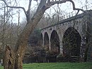
  41. ^ Historic England. "Derwent Viaduct (1417625)". National Heritage List for England. Retrieved 17 January 2019.
  42. ^ a b c d e f Philip's 1997, p. 178.
  43. ^ Historic England. "Belper Bridge (1087394)". National Heritage List for England. Retrieved 17 January 2019.
  44. ^ a b c d Philip's 1997, p. 191.
  45. ^ Historic England. "Milford Bridge (1099189)". National Heritage List for England. Retrieved 17 January 2019.
  46. ^ Historic England. "Duffield Church Bridge (1158235)". National Heritage List for England. Retrieved 17 January 2019.
  47. ^ a b c d Philip's 1997, p. 205.
  48. ^ a b c d e f g h i Philip's 1997, p. 219.
  49. ^ Historic England. "Handyside Bridge (1215438)". National Heritage List for England. Retrieved 17 January 2019.
  50. ^ Historic England. "St Marys Bridge (1215897)". National Heritage List for England. Retrieved 17 January 2019.
  51. ^ "New bridge for Derby". BBC. Retrieved 28 January 2019.
  52. ^ Historic England. "Derwent Bridge (1417807)". National Heritage List for England. Retrieved 17 January 2019.
  53. ^ a b Philip's 1997, p. 220.
  54. ^ "New Raynesway bridge". Cass Hayward. 2009. Retrieved 27 January 2019.
  55. ^ a b c Philip's 1997, p. 234.
  56. ^ a b Philip's 1997, p. 235.

External links[]

Retrieved from ""