List of lighthouses and lightvessels in Belgium
This is a list of lighthouses and lightvessels in Belgium.
Lighthouses[]
| Name | Image | Region | Location Coordinates |
Year built |
Notes |
|---|---|---|---|---|---|

|
Flanders | Blankenberge 51°18′45.3″N 3°06′52.1″E / 51.312583°N 3.114472°E |
1952 | The tower has a U-shaped cross-section. It is attached to a maritime museum.[1] | |

|
Flanders | Heist, Zeebrugge 51°20′15.2″N 3°13′49.3″E / 51.337556°N 3.230361°E |
1907 | This tower used to serve in a range of leading lights until 1983.[1] | |

|
Flanders | Heist, Zeebrugge 51°20′22.2″N 3°13′38.5″E / 51.339500°N 3.227361°E |
1912 | This tower used to serve in a range of leading lights until 1983.[1] | |
| Lange Nelle Lighthouse | 
|
Flanders | Ostend 51°14′10.8″N 2°55′49.7″E / 51.236333°N 2.930472°E |
1949 | In 1994, the tower was painted with two blue waves on white ground. |

|
Flanders | Nieuwpoort 51°09′16.8″N 2°43′47.9″E / 51.154667°N 2.729972°E |
1949 | A lighthouse called Vierboet was established in downtown Nieuwpoort already in 1284. It got a lantern in 1863 and was eventually destroyed in World War I. The current lighthouse is the successor to a tower from 1926.[1] | |
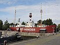
| Offshore | 30 kilometres (19 mi) northwest of Nieuwpoort 51°07′28.6″N 4°17′27.2″E / 51.124611°N 4.290889°E |
1950 | The lightvessel in a series of three used in the West-Hinder shoal off Nieuwpoort. It was decommissioned in 1972 and sold in 1976. While being used as a floating restaurant in Ostend, it sank at its berth in 1978 but could be refloated. In the 1980s, it was sold for scrap but was eventually saved. It was towed to Rupelmonde in 2002 where it can be visited.[1] | ||
|
Offshore | 30 kilometres (19 mi) northwest of Nieuwpoort 51°20′03.9″N 3°12′29.5″E / 51.334417°N 3.208194°E |
1950 | This lightvessel was decommissioned in 1994. It is now berthed on dry land in a theme park at the Zeebrugge water front.[1] | |

|
Offshore | 30 kilometres (19 mi) northwest of Nieuwpoort 51°13′46.5″N 4°24′16.3″E / 51.229583°N 4.404528°E |
1950 | This lightvessel was heavily damaged in 1960 in a collision with the Norwegian tanker Branita. On its way to Ostend for repair, the lightvessel sank, but could be salvaged and resumed duty. It was decommissioned in 1992, and donated to the city of Antwerp in 1995.[1] | |
| Offshore | 30 kilometres (19 mi) northwest of Nieuwpoort 51°23′00″N 2°26′00″E / 51.38333°N 2.43333°E |
1992 (c.) | This fixed installation replaced the Westhinder lightvessels around 1992.[1] | ||

|
Flanders | Zeebrugge 51°20′51.5″N 3°12′10.8″E / 51.347639°N 3.203000°E |
1905 | In World War I, the lighthouse was heavily damaged during the British Zeebrugge Raid in 1918.[1] |

See also[]
- Lists of lighthouses and lightvessels
References[]
External links[]
| Wikimedia Commons has media related to Lighthouses in Belgium. |
| Wikimedia Commons has media related to Lightships of Belgium. |
- Rowlett, Russ. "The Lighthouse Directory". University of North Carolina at Chapel Hill.
Lighthouses and lightvessels in Europe | |
|---|---|
| Sovereign states |
|
Dependencies and other territories |
|
| Types |
|  | ||||
|---|---|---|---|---|---|---|
| Fixtures | ||||||
| Maintenance | ||||||
| Locations |
| |||||
| Categories |
| |||||
| Global organizations | ||||||
| ||||||
Categories:
- Lists of buildings and structures in Belgium
- Transport in Belgium
- Lists of lighthouses
- Belgium transport-related lists
- Lighthouses in Belgium