List of lighthouses in Kiribati
This is a list of lighthouses in Kiribati, an island nation in the central Pacific Ocean.[1][2]
Lighthouses[]
| Name | Image | Year built |
Location & coordinates |
Class of Light[2] | Focal height[2] |
NGA number[2] |
Admiralty number[2] |
Range nml[2] |
|---|---|---|---|---|---|---|---|---|
| Betio Lighthouse | n/a | Betio 1°21′15.3″N 172°55′14.8″E / 1.354250°N 172.920778°E |
Fl W 8s. | 32 metres (105 ft) | 11080 | M8512 | 18 | |
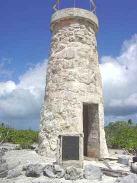
| Enderbury Island Lighthouse |  |
1938 | Enderbury Island 3°08′29.0″S 171°05′28.0″W / 3.141389°S 171.091111°W |
inactive | 9 metres (30 ft) (tower) | n/a | n/a | n/a |
| Canton Island Lighthouse | Image | 1838 | Canton Island 2°48′55.1″S 171°42′44.4″W / 2.815306°S 171.712333°W |
inactive | 8 metres (26 ft) (tower) | n/a | n/a | n/a |
| Tabuaeran Lighthouse |  |
1957 | Tabuaeran 3°51′31.6″N 159°21′43.1″W / 3.858778°N 159.361972°W |
F W | 9 metres (30 ft) | 11108 | M8528 | 12 |
| Tarawa Lighthouse | n/a | Tarawa 1°38′09.3″N 172°57′23.1″E / 1.635917°N 172.956417°E |
L Fl W 20s. | 21 metres (69 ft) | 11076 | M8508 | n/a |

See also[]
- Lists of lighthouses and lightvessels
References[]
- ^ Rowlett, Russ. "Lighthouses of Kiribati". The Lighthouse Directory. University of North Carolina at Chapel Hill. Retrieved 2016-10-19.
- ^ a b c d e f List of Lights, Pub. 111: The West Coasts of North and South America (Excluding Continental U.S.A. and Hawaii), Australia, Tasmania, New Zealand, and the Islands of the North and South Pacific Oceans (PDF). List of Lights. United States National Geospatial-Intelligence Agency. Retrieved 19 October 2016
External links[]
- Rowlett, Russ. "The Lighthouse Directory". University of North Carolina at Chapel Hill.
| Types |
|  | ||||
|---|---|---|---|---|---|---|
| Fixtures | ||||||
| Maintenance | ||||||
| Locations |
| |||||
| Categories |
| |||||
| Global organizations | ||||||
| ||||||
Categories:
- Lists of lighthouses
- Lists of buildings and structures in Kiribati