List of lighthouses in Manitoba
This is a list of lighthouses in the province of Manitoba, Canada.[1][2]
Lighthouses[]
| Name | Image | Year built |
Waterbody | Location & coordinates |
Class of Light | Focal height |
CCG number |
Range nml |
|---|---|---|---|---|---|---|---|---|
| Black Bear Island Light | Image | 1898 | relocated | Selkirk 50°08′48″N 96°51′54″W / 50.146745°N 96.864878°W |
inactive | 8 metres (26 ft) tower height |
ARLHS CAN-736M |
|
| Cox Reef Light | Image | 1905 est. | Lake Winnipeg | Cox Reef 52°19′16″N 97°13′05″W / 52.321002°N 97.217972°W |
Fl W 4s. | 15.2 metres (50 ft) | 1600 | n/a |
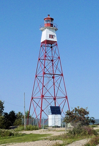
| George Island Light | Image | 1906 | Lake Winnipeg | George Island 52°49′08″N 97°36′58″W / 52.8188832°N 97.6159935°W |
Fl W 5s. | 20.1 metres (66 ft) | 1608 | 9 |
| Gimli Light | Image | 1973 | Lake Winnipeg | Gimli 50°37′45″N 96°58′51″W / 50.629140°N 96.980893°W |
Fl R 4s. | 12.8 metres (42 ft) | 1569 | n/a |
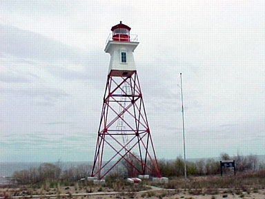
| Gull Harbour Light | Image | 1926 | Lake Winnipeg | Hecla island 51°11′34″N 96°36′16″W / 51.192717°N 96.604454°W |
Fl W 5s. | 27.4 metres (90 ft) | 1583 | 7 |
| Hecla Island Range Rear Light |  |
n/a | Lake Winnipeg | Hecla Island 51°00′34″N 96°45′00″W / 51.009527°N 96.750021°W |
F W | 15.2 metres (50 ft) | 1579 | 14 |
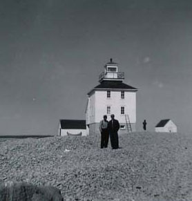
| Red River Range Light | Image | 1914 | relocated | Selkirk 50°08′48″N 96°51′54″W / 50.146740°N 96.864868°W |
inactive | 8 metres (26 ft) tower height |
ARLHS CAN-738M |
|
| Warren Landing Lower Range Front Light | Image | 1908 | Lake Winnipeg | Purvis Island 53°42′01″N 97°51′00″W / 53.700249°N 97.849866°W |
F W | 7.5 metres (25 ft) | 1620 | n/a |
| Warren Landing Lower Range Rear Light | 1908 | Lake Winnipeg | Purvis Island 53°42′23″N 97°50′35″W / 53.706360°N 97.843032°W |
F W | 17 metres (56 ft) | 1621 | n/a | |
| Warren Landing Upper Range Front Light | Image | 1908 | Lake Winnipeg | Division No. 22 53°41′40″N 97°52′14″W / 53.694446°N 97.870521°W |
F W | 9 metres (30 ft) | 1622 | n/a |
| Warren Landing Upper Range Rear Light | Image | 1908 | Lake Winnipeg | Division No. 22 53°41′48″N 97°52′13″W / 53.696746°N 97.870376°W |
F W | 15 metres (49 ft) | 1623 | n/a |
| Winnipeg Beach Breakwater Light | Image | 2001 | Lake Winnipeg | Winnipeg Beach 50°30′21″N 96°57′48″W / 50.505905°N 96.963455°W |
Fl R 4s. | 10.8 metres (35 ft) | 1565 | n/a |

See also[]
References[]
- ^ Rowlett, Russ. "Lighthouses of Canada: Manitoba". The Lighthouse Directory. University of North Carolina at Chapel Hill. Retrieved 2017-02-03.
- ^ Lake Winnipeg Canadian Coast Guard. Retrieved 3 February 2017
- Rowlett, Russ. "Lighthouses of Canada: Manitoba". The Lighthouse Directory. University of North Carolina at Chapel Hill. Retrieved 4 August 2009.
External links[]
| Wikimedia Commons has media related to Lighthouses in Manitoba. |
- List of Lights, Buoys and Fog Signals Canadian Coast Guard. Retrieved 19 March 2017
Categories:
- Lighthouses in Manitoba
- Lists of lighthouses in Canada
- Manitoba-related lists
- Lists of buildings and structures in Manitoba